

Facing west on Highland Park's south border with Detroit at Woodward Avenue.
This article is the sixth in a series exploring the Detroit city limits in detail. The last post in this series, The Annexations of 1916, covers the history of the additions to Detroit which enveloped Highland Park and Hamtramck. Highland Park's border today runs for just over seven miles, sharing the boundary for one quarter of a mile with Hamtramck and the rest with Detroit.

Highland Park's border in relation to Detroit's.
As covered in Part One of this blog's series on Highland Park's early development history, the municipality's borders have changed twice since the village was founded in 1889. Detroit annexed more than half the village in 1891, and two years later the borders were expanded to their current size. Local Act 264 of 1893, amending the original Highland Park incorporation law, was approved by Governor John T. Rich on March 8, 1893. Highland Park's 1968 city charter contains a detailed legal description of the boundaries, which we will follow step-by-step.
The Point of Beginning
As is common with legal property descriptions, Highland Park's border begins by identifying a point of beginning:
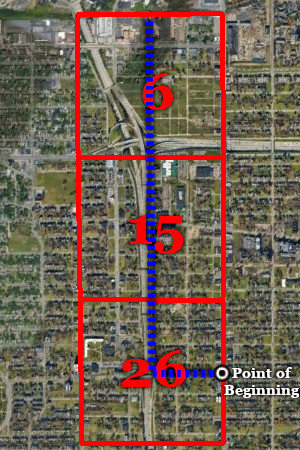
Commencing at a point where the easterly line of quarter section twenty-six (1/4 Sec. 26) of the ten thousand acre tract, so-called, intersects the northerly boundary line of the City of Detroit, said point being the northeasterly corner of the southerly half (S. 1/2) of said quarter section twenty-six (1/4 Sec. 26) [...]
The Ten Thousand Acre Tract was an old government land survey which divided this area into 60 numbered rectangular "quarter sections," each containing about one quarter of a square mile. The point of beginning lies at the center of the east line of quarter section 26:

The east line of quarter section 26 is now the center of Hamilton Avenue. The point of beginning lies where an east-west line dividing this section in half intersects the center of Hamilton Avenue. According to the plat for Wilkins and Willette's Subdivision (surrounding Webb Street east of Hamilton Avenue), this east-west dividing line is located 10 feet behind the rear of the lots on the north side of the street.

The vicinity of Highland Park's point of beginning with part of Wilkins and Willette's Subdivision superimposed.
Starting the South Border

Facing west on Hamilton Ave., north of Webb St.
From this point of beginning, the boundary description continues with the first border segment:
[...] thence running westwardly, along the northerly line of the southerly half of quarter section twenty-six (1/4 Sec. 26), to the westerly line of the easterly half (E. 1/2) of quarter section twenty-six (1/4 Sec. 26) [...]
This line is drawn from our point of beginning to the very center of quarter section 26, which will also be southwest corner of Highland Park. This line is clearly indicated on the plat for Robert Oakman's Hamilton Boulevard Subdivision, which made no attempt to accommodate the municipal border in its layout. The city border runs through several buildings along Webb Street.

Detail from Robert Oakman's Hamilton Boulevard Subdivision (1913).
Today, the southwest corner of Highland Park lies in a patch of grass few feet beyond the chain-link fence along the Webb Street entry ramp onto the northbound John C. Lodge Freeway.


The southwest corner of Highland Park.
The Western Border
From this point, the boundary description takes a turn and begins to trace Highland Park's western border with Detroit, straight up through the centers of quarter sections 26, 15, and 6:
[...] thence northwardly along the westerly line of the easterly half (E. 1/2) of quarter section twenty-six (1/4 Sec. 26), along the westerly line of the easterly half (E. 1/2) of quarter section fifteen (1/4 Sec. 15) and along the westerly line of the easterly half (E. 1/2) of quarter section six (1/4 Sec. 6) to the northerly line of the ten thousand acre tract [...]
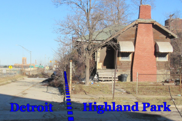
Following the border up from the southwest corner, the line crosses the Lodge Freeway ramp at a steep angle as it enters the Tuxedo Manor Subdivision, located between Tuxedo and Elmhurst streets. Here, the border once cut through the back ends of lots which were condemned for the freeway's construction. The sidewalk along the freeway service drive was originally part of an alley.

Part of the Tuxedo Manor Subdivision.
As the border crosses Elmhurst Street, it becomes far easier to locate visually, as all subdivisions between Elmhurst and Sturtevant streets end exactly at the north-south dividing line running through these quarter sections. For six blocks, the line between the sidewalk and the properties to the east coincides with the city border. The sidewalk and freeway service drive here are entirely located within Detroit.

Facing north at Elmhurst St.
 Facing north from near Highland St.
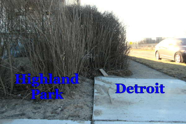
Facing south at Sturtevant St. and John C. Lodge Service Drive.
Nature does not recognize human boundaries.
Facing north at Sturtevant St.
Beyond Sturtevant Street, the border follows the western property line of Bella Vista Glen Senior Apartments, formerly the Highland Park General Hospital.
North of Glendale Avenue, the border continues along Thompson Street up to Labelle Street. However, the line does not run down the center of Thompson Street, but rather follows the western edge of the right-of-way. Thompson Street lies entirely within Highland Park.

What appears to be a home on Thompson St. in Highland Park is actually 1800 Buena Vista St., Detroit, having been cut off from the rest of the city by the freeway.
(Google Street View)
From Labelle Street to Oakman Boulevard, the border cuts through lots within the Metzger Motor Car Subdivision Number 2. Only one building in this area actually straddles the city border, a church at 809 Oakman Boulevard. The west 10.92 feet of this property lies in Detroit, and the remainder in Highland Park.

Facing south at Holy Ghost Temple True Gospel of Christ on the Detroit-Highland Park border.

After crossing Oakman Boulevard, the border skirts the property where the Sanders Confectionary candy factory and bakery was constructed in 1941. Behind the plant, the border cuts through a 66-foot strip of land that was once part of the Detroit Terminal Railroad. Here the line finally meets the north line of quarter section 6, which is also the north line of the Ten Thousand Acre Tract.
This brings us to the final portion of Highland Park's western boundary:
[...] thence northwardly on a line parallel with Hamilton Blvd., (now known as Hamilton Ave.) to the center of Six Mile Road, so-called, (now known as McNichols Road) [...]
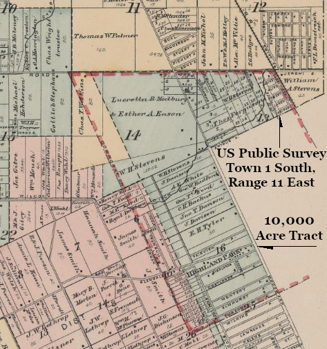
North of the Ten Thousand Acre Tract, land has been surveyed according to the US Public Land Survey System, which has been explored previously in this blog (see Part One and Part Two). The northern part of Highland Park lies within what is known as "Town 1 South, Range 11 East," because it is the first township south of Michigan's baseline (Eight Mile Road), and eleventh east of the meridian. Highland Park includes portions of sections 13, 14, and 15 of this township. After leaving quarter section 6 of the Ten Thousand Acre Tract, Highland Park's western border continues along the same direction through sections 14 and 15 of the US Public Lands Survey area, as illustrated in the map below.
Detail from an 1893 map of Greenfield Township.
(Library of Congress
After entering Section 14, the border crosses another 66-foot railroad right-of-way and then enters the Wetmore Industrial Subdivision. Platted in 1939, this subdivision helpfully accommodates the city border in its design.

A building on the Highland Park side of the Wetmore Industrial Subdivision, owned by Diversitak, Inc., was built right up to the city limits, making the border clearly identifiable. A change of pavement on Midland Street nearby also indicates the border's location.


Facing northwest on Midland Street.
The final three-quarters of a mile of the western border cuts through several subdivisions which were laid out without any regard for how many lots would straddle the city limits.

The border just barely misses 400 Pilgrim St., Highland Park.

"Eason's Subdivision of Lots 15, 16, 17 and West 17.63 Feet Lot 18 of J.H. Eason's Subdivision of S.W. 1/4 Frac. Section 14 T.1.S.R.11.E.," platted in 1912, superimposed over a Google Earth satellite image. Note that Kanada Ave. is now Puritan Ave., and Oxford Ave. now Joslyn St.
It is not clear why subdividers disregarded the city border. One possible explanation is that many assumed Highland Park's annexation to Detroit was inevitable, after which the boundary would disappear anyway. As it stands, however, the situation creates many awkward anomalies. A home on Brighton Street, pictured below, is cut in two by the city limits. The Highland Park portion is owned by an occupant, according to tax records, while the Detroit portion is property of an LLC based in Los Angeles. The vacant lot next door mostly falls within Detroit, and is property of the Detroit Land Bank Authority, while the triangle remnant covering less than 19 square feet lying in Highland Park is owned by the State Land Bank Authority.

The city border bisects lots 360 and 361 of the Hamilton Park Subdivision.
After cutting diagonally through the Palmer Park Estates Apartments, Highland Park's western border terminates in the center of McNichols Road. The plat for the Log Cabin Heights Subdivision, surveyed by civil engineering firm Mason L. Brown and Son, indicates that the northwestern corner of the city lies 143.80 feet west of the northwest corner of section 14 of this township.

The northwest corner of Highland Park, circled, as designated by the plat for the Log Cabin Heights Subdivision.


The northwest corner of Highland Park, in McNichols Rd. east of Log Cabin St.
(Google Street View)
The Northern Border
After the western border terminates in the center of McNichols Road, we turn eastward to draw Highland Park's northern boundary:
[...] thence eastwardly, along the center of the Six Mile Road, so-called, (now known as McNichols Road), to the westerly line of the right of way of the Detroit, Grand Haven & Milwaukee Railway, as it existed March 8, 1893 (now known as Grand Trunk Western Railroad Company); [...]
McNichols Road is actually centered around a "section line" in the US Public Land Survey, which here is the north line of sections 13, 14 and 15 of "Town 1 South, Range 11 East." We can locate this section line by finding "monument boxes" placed in the roadway every half mile.

The northwest corner of Highland Park lies 143.80 feet west of the survey marker protected by this monument box.

The border at McNichols and Cardoni.
The border becomes more difficult to locate east of Oakland Avenue because it does not actually follow the center of the street here. Due to the widening and reconfiguration of McNichols, the road's original center line now runs close to the northern curb.

 Facing east down McNichols Rd. toward Highland Park's northeast corner.
The Eastern Border
After the northern border terminates at the edge of the railroad right-of-way, now owned by Canadian National, the eastern border begins, following the edge of this property all the way down:
[...] thence southwardly, along the westerly line of the right of way of the Detroit, Grand Haven & Milwaukee Railway, as it existed March 8, 1893 (now known as Grand Trunk Western Railroad Company) [...]
Surrounded by industrial land, Highland Park's eastern border is mostly inaccessible. The only public crossings over the Detroit/Highland Park border are at McNichols Road and the Davison Freeway.

The border as seen from the exit ramp from eastbound Davison Freeway to northbound I-75, facing north.
(Google Street View)
The only other place where one may approach Highland Park's eastern border is where it meets the City of Hamtramck, near Connecticut Avenue and Park Court at the southern end of the city.
Since Highland Park's borders were established in 1893, some parts of the the railroad right-of-way has been expanded. However, this did not affect the city border, which still follows the original railroad property line. The border continues its journey southward, along the original railroad right-of-way, down into the Ten Thousand Acre Tract:
[...] to the point where said westerly line of said right of way intersects the northerly line of the southerly half (S. 1/2) of quarter section twenty-three (1/4 Sec. 23); [...]

(Library of Congress)
The southeast corner of Highland Park lies within the expanded railroad right-of-way, now owned by Canadian National.

The southeast corner of Highland Park as indicated on the Walter P. Chrysler Urban Renewal Plat.
Completing the Southern Border
Highland Park's border turns southwest, cutting through the middle of quarter sections 23, 25, 25 and 26 of the Ten Thousand Acre Tract until we return to our point of beginning:
[...] thence westwardly, along the northerly line of the southerly half (S. 1/2) of quarter section twenty-three (1/4 Sec. 23), along the northerly line of the southerly half (S. 1/2) of quarter section twenty-four (1/4 Sec. 24) and along the northerly line of the southerly half (S. 1/2) of quarter section twenty-five (1/4 Sec. 25) to the place of beginning; all of said territory embraced within the foregoing boundaries being within the County of Wayne.

After cutting through the Walter P. Reuther Industrial Renewal Plat, the city border runs down the middle of the alley between Woodland and Tennyson east of Woodward, and between Webb and Tuxedo west of Woodward.

The border at Oakland Blvd., facing west.

Facing north at Brush St.
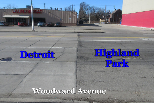
Facing west at Woodward Ave.

Facing west down the Tuxedo/Webb alley from Woodward.
Just within the border at Second Avenue, the street makes a jarring turn. This was the result of the Second Avenue as laid out in Captain Stevens' original Highland Park subdivision not aligning with the Second Avenue in Detroit. Two subdivisions at the southern end of Highland Park did not accommodate for Second Avenue at all. Connecting the avenue between the two municipalities required the condemnation of multiple lots, in whole and in part, as indicated in the illustration below.

Detail from a 1904 real estate atlas with today's Second Avenue highlighted in yellow and the lots to be condemned (in full or in part) highlighted in red.
(Bentley Historical Library)
 Google Earth image of Second Ave. with Tuxedo Park Subdivision superimposed.
 A Highland Park home at Tuxedo and Second, spotted from the border.
Facing north on Second Avenue.
When the border reaches Third Avenue, another jog in the road is seen. Although obviously not as dramatic as the turn at Second Avenue, this street also involved condemning lots in these subdivisions.

Facing north on Third Avenue.
After running for one final block through the alley between Tuxedo and Webb, we at last complete our journey, returning once again to the point of beginning.


Excellent research. Thank you!
ReplyDeleteInteresting!
ReplyDeleteQuestion, did you mean that northern border gets a bit harder to trace on McNichols east of Oakland? Because that appears to be where the street begins to widen.
The eastern border has always been interesting to me, because most modern maps seem to show it either including the CN rail line or going to the centerline, and that appears not to actually be the case. I've found in my own city that even city workers don't actually seem to know where the borders are. lol
The northwest part of the city is interesting, too. The funny thing is that state law allows simply boundary readjustments by mutual agreement for lots cross municipal boundaries thereby placing "factional" parts of lots entirely into one municipality of the other. I found one place in he metro in which a lot is in THREE different municipalities (St. Clair Shores, Harrison Twp & Clinton Twp).
The boundary adjustments would actually make it easier for assessors in these towns. But, again, it's something I imagine a lot of them don't even know about or care to bring to their city councils. Seems like this all could have been avoided by simply putting a requirment into annexation and incorporation laws that said that a boundary had to follow a property line.
Yes, I did mean to say Oakland and not John R--my brain is mush by the time I finish a post, so I appreciate the help! :) Part of what inspires these border posts is the ambiguity on most readily available maps. The western border usually shows up a little weird on maps, which led me to wonder whether HP annexed some Detroit lots after the Lodge was constructed, but that did not turn out to be the case after all. I would not blame any city workers for not locating exact boundaries under these conditions. In fact I am pleasantly surprised when a pavement change or a city limits sign is found in just the right location. It pays to hire good surveyors!
DeleteThe HP detour was fascinating but I'm happy to see this series front and center again.
ReplyDeleteAre comments not turned on?
ReplyDeleteYes, but I have them set up to require moderation before being published. Spam bots had been posting fake comments. :/
DeleteWasn't sure where to ask this, but would you happen to have a blog post on why M-102 turns off of East 8 Mile and continues along Vernier? I suspect its because it's probably where it meets the old ribbon farm layout from the survey layout, but I've never seen detail on which this all happened. And 8 Mile does continue beyond Vernier for a bit before breaking up into disconnected sections.
Delete