

Blue = Farmington Hills; lavender = Farmington.
On July 1, 2023, Farmington Hills celebrates the 50th anniversary of its incorporation as a city. This blog post documents every municipal border change which occured in this area, leading up to the shape the city would take on upon its founding in 1973.
The cities of Farmington and Farmington Hills today occupy a six-mile-by-six-mile area which was once Farmington Township. According to the United States Public Land Surveying System (USPLSS), this particular township is designated Town 1 North, Range 9 East, because it is located within the first row of townships north of the Michigan Baseline, and the ninth column of townships east of the Michigan Meridian. (For past blog posts detailing early USPLSS surveys in Michigan and the Detroit area, see: Part 1 and Part 2).
Farmington Township originally covered much more than just the 36 square miles of Town 1 North Range 9 East. When first established by an act of the Michigan Territorial Legislature on April 12, 1827, its territory included all of what is now Novi, Commerce, Milford and Lyon townships. Before this change, the lower two rows of townships of Oakland County were all considered to be Bloomfield Township, and the upper three tiers made up Oakland Township.

Township borders established April 12, 1827.
The blue dotted lines indicate Town 1 North Range 9 East.
Six years later, another act of the territorial legislature reduced Farmington Township's size so that it consisted solely of Town 1 North Range 9 East, while the four townships detached from it became the original Novi Township. The law, entitled "An Act to organize the townships of Royal Oak and Novi in the county of Oakland," was passed on June 9, 1832, and became effective on March 31, 1833.
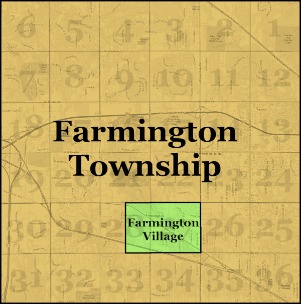
 This template of Town 1 North Range 9 East, superimposed over a modern map, will be used to illustrate each border change within this area up until the establishment of the City of Farmington Hills. The numbers inside each square mile indicate its section number according to the USPLSS.
The first white settlers in Farmington had arrived in 1824, led by Arthur Power of Farmington, New York. Although a town center gradually began to grow around today's Shiawassee Road near Farmington Road, there was apparently little need for any additional level of government for more than thirty years. By the late 1860s, however, "there arose certain conditions regarding the health of the people, the care of the streets, etc., that demanded change," and a village form of government was established. ("Voters read!" The Farmington Enterprise, Sep. 11, 1925.) On March 25, 1867, the Michigan State Legislature passed "An Act to incorporate the village of Farmington," defining its territory as the east half of section 28 and the west half of section 27 of Town 1 North Range 9 East.

The Village of Farmington, incorporated March 25, 1867.
The village borders remained unchanged for another thirty years, until the arrival of electric interurban railway service to the area. Michigan Governor Fred M. Warner, a Farmington resident, explained in a 1906 Detroit Free Press interview how the village had recently come to expand its borders:
"The limits of the village are a mile and a half square. It used to be a mile, but we added another half mile. It came about like this: The railway company, when it got the franchise, promised to build the power house in the village. Instead, the company bought 40 acres outside the town. It was done, of course, to escape village taxes. That made our people mad. They felt that they had been imposed on. Some were for getting out an injunction. Instead, a bill was introduced at Lansing extending the corporate limits of Farmington. It passed, and now the company pays village taxes;—that is, about $500 a year."
("Gov. Warner's summer home at Cass Lake." Detroit Free Press, Aug. 5, 1906.)

Farmington Junction, 31505 Grand River Avenue.
The change was made official on January 30, 1901, when the state legislature passed an act to amend the 1867 Farmington village incorporation law, redefining its territory to include the east half of section 27 of the township.
 The Village of Farmington annexed the east half of section 27 in 1901.
It was during Detroit's phenomenal suburban sprawl of the 1920s when the Village of Farmington incorporated as a city. Under Michigan law, villages remain part of their townships, while cities are independent municipalities. Becoming city allowed Farmington to keep highway taxes collected from its taxpayers to spend on local streets, rather than having those funds spread out on road repairs throughout the township. Becoming a city also allowed Farmington to establish a local court. ("Voters read!" The Farmington Enterprise, Sep. 11, 1925.)
Only 80 citizens voted on the question of incorporation at the election of September 14, 1925, and they overwhelmingly favored the city form of government by 72 to 8. There was better turnout at the election to approve the drafted city charter and select city officers on February 15, 1926, where 166 voted in favor of adopting the charter and 60 voted against. The charter was made official upon adoption by the people that day, and thus the City of Farmington came into being.

The City of Farmington was incorporated February 15, 1926.
The Great Depression and World War II temporarily interrupted Farmington's transformation from a farming community into a residential suburb of greater Detroit. The first annexation to the City of Farmington occurred in 1948, with the addition of the Floral Park subdivision and the west 132 feet of the Tarabusi Grand River Gardens and Regal Orchards subdivisions. City voters approved the annexation by 101 to 30 at the December 9, 1948 election, and the vote inside the annexation area was 105 in favor, 16 against. A newly constructed model home in the Floral Park subdivision—22420 Lilac Street—served as a temporary polling location for the affected township voters. ("Vote today!" Farmington Enterprise, Dec. 9, 1948.) The annexation would bring city services into this largely undeveloped 97-acre area, including city water, sewers, sidewalks and street lighting, which the township government could not provide.

The City of Farmington's first annexation, approved by voters December 9, 1948.
The next annexation did not require a vote of the people because the area, covering just 4.052 acres, was uninhabited. The land part of the Glenview subdivision, owned by William and Molly Ramsey, who instigated the annexation procedure in order to ensure city services for every lot in the development.

The Farmington City Council approved this annexation on September 19, 1955, creating a small bump-out on the city's north side.

Farmington's northernmost annexation was approved September 19, 1955.
The next change in municipal boundaries occurred within the township, northeast of the City of Farmington. On August 7, 1956, electors living in section 12 of Farmington Township voted to incorporate that entire square mile as the Village of Wood Creek Farms, by 72 to 46. This was not a "village" in a traditional sense. There were no industries and few if any commercial properties. Rather, this was a modern residential subdivision with a semi-rural feel, with most lots covering one or two acres. Incorporating as a village facilitated improved city services to residents.
 All of section 12 was incorporated as the Village of Wood Creek Farms in 1956.
The City of Farmington annexed a small parcel of land on its southern border later that year. Because the property was unoccupied and owned by the city itself, the action required only a vote of the city council, which approved the annexation on October 1, 1956. Once used as a city dump, the property now contains sewerage infrastructure.

Needing to increase its tax base, especially with the acquisition of industrial land, the city expanded southward to Eight Mile Road the following year with the annexation of the Farmington Little Farms subdivision as well as tracts of unplatted land. At an election of April 1, 1957, city voters supported the measure by 653 to 234. Only ten votes were cast by residents of the affected area, who approved the annexation by 7 to 3.

1958: The Farmington Interceptor Opens the Township to Development
Farmington Township enjoyed record-breaking numbers of new home construction permits in the years 1955 and 1956. However, by early 1957 it was clear that the boom was definitely over. ("Township reports decline in home building during first period of '57." The Farmington Enterprise, Apr. 11, 1957.) Despite the township's desirable suburban location, the lack of adequate sewer facilities essentially barred further development. Most Farmington Township homes were served by private septic systems, but the bulk of the remaining undeveloped land was unfit for septic systems due to soil percolation.
The local real estate industry was greatly relieved when, in January 1958, the Oakland County Board of Supervisors approved construction of the Farmington Interceptor Sewer, which allowed Farmington Township as well as the City of Keego Harbor and parts of West Bloomfield and Southfield townships to discharge into the City of Detroit's sewer system. Without this $5.7 million public works project and the City of Detroit's infrastructure, Farmington Township would see few if any additional profitable real estate developments, and Farmington Hills would not go on to be the second most populous city in Oakland County today.

The Farmington Interceptor and its major branches.
(Source)
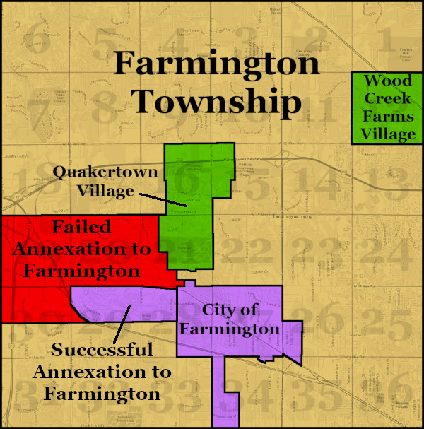
In order to connect new developments to the Farmington Interceptor, many new trunk sewers and lateral arms would have to be constructed, and Farmington Township was poorly equipped to borrow the necessary funds. A significant number of additional subdivisions would ultimately require the incorporation of new villages or cities within the township area in order to take on the debt. The year 1958 saw an unprecedented flurry of attempts at incorporation throughout Farmington Township.

Annexation and incorporation proposals made between March and May of 1958.
By March 1958, rumors were circulating that the City of Farmington was planning a large annexation from the southwest corner of the township. According to Robert J. Mowitz and Deil S. Wright's 1962 book, Profile of a Metropolis: A Case Book, which contains an entire chapter dedicated to Farmington Township's 1958 incorporation proposals:
The word had spread that city had been sending members of the police force to collect signatures for an annexation petition from township residents in a low-income area adjacent to the city. This area was badly in need of water and sewers—two services which, rumor had it, the police were offering as bait in order to obtain signatures. (p. 586)
In order to protect themselves from city annexation, township residents of several higher-income subdivisions north of the city rushed to file a petition to organize their own municipality—the Village of Quakertown—on March 24, 1958. Having beaten the city to the punch, Farmington had to adjust its proposed annexation area to exclude any part of Quakertown, filing its petition two days later.

The March 27, 1958 edition of The Farmington Enterprise.
(Farmington Community Library)
Just two months later, two additional incorporation proposals were filed. On May 13, the state received a petition to incorporate the City of Farmington Woods out of 14.5 square miles of the township. A petition to incorporate the City of Clarenceville was received on May 19. According to Mowitz and Wright, these proposals "were designed to prevent annexation by the city." (p. 589)
The first two proposals—the annexation to Farmington and the incorporation of Quakerville—were decided at the August 5 primary election. Quakerville voters approved incorporation by 107 to 13. However, a faction of residents within the area proposed to be annexed to the City of Farmington made a persuasive but dubious argument that the township government could supply the currently lacking city services without city-level taxation. Although city residents approved the annexation 425 to 206, affected township voters rejected it, with 391 opposed and only 74 in favor.
The remaining incorporation measures were both defeated at the November 5 election, with the Farmington Woods area voting 1,367-1,906, and Clarenceville, 342-1,061. Although these proposals were intended to prevent annexation to the City of Farmington and preserve the area's rural character, arguments against incorporation were chiefly focused on keeping taxes low.
There was one final incorporation attempt in 1958. The entire area which the City of Farmington had just attempted to annex was proposed to incorporate as the Village of Woodcroft, named after a subdivision located just west of the city. The residents behind the movement cited an 1895 state law which was supposed to allow such an incorporation without a public vote. However, the Oakland County Board of Supervisors rejected that petition on December 11, 1958.

1965-1973: The Fight for a Tax Base
In 1965, the City of Farmington attempted a more modest west-side annexation, again including the Woodcroft subdivision. Although city voters favored the annexation by 960 to 185, only 60 township voters in this 457-acre tract approved, while 85 opposed.

The following year, there was a proposal to incorporate all of Farmington Township, including its villages of Wood Creek Farms and Quakertown, as a single city—a precursor to Farmington Hills. The list of names considered for the possible city even included "Farmington Hills." However, this proposal was overwhelmingly rejected by voters on June 6, 1966, with 1,547 votes in favor, and 5,657 against.

The Observer of Farmington, Jan. 5, 1966.
(Farmington Community Library)
Later that year, the City of Farmington proposed two annexations. One was identical to the attempted west-side annexation the previous year, while the second proposal sought to take in 1,828 acres northwest of that. At the November 8, 1966 election, the first proposal passed, both in the city (2,399-495) and in the affected area (77-67). However, the second one was rejected, with 86 township voters rejecting it, and only 18 voting in favor.
Annexation proposals of 1966.
The following year, there was a second attempt to consolidate all of the territory outside the City of Farmington, which failed by 204 votes. With a turnout of just 30%, 2,106 votes were cast in favor and 2,310 against the proposition on October 23, 1967.
What was to be the final annexation to the City of Farmington occurred in December 1968. A tiny triangular portion of the Chatham Hills No. 2 subdivision was found to have been accidentally excluded from the previous year's annexation. Covering just 0.276 acres, this fragment of the back yard of a home on Heatherton Road was attached to the city without any need for a citywide vote.
 Detail from the Chatham Hills No. 2 subdivision plat.
In 1969, there was a movement to fully consolidate all 36 square miles of Town 1 North, Range 9 East as a new, unified city, finally ending the fight between city and township over taxable land. To pass, the approval of all four municipalities was required. The vote in favor of each at the November 4, 1969 election was as follows:
- Farmington Township: 67%
- Quakertown Village: 55%
- Wood Creek Farms Village: 66%
- Farmington City: 44%
Despite Farmington's rejection of consolidation with its neighbors, the city proposed to annex most of the southern half of Farmington Township one year later. Although city voters overwhelmingly approved the measure, by 2,340 to 1,361, it was soundly defeated within the affected area, by 3,369 to 1,281, on November 3, 1970.

The following year, Farmington Township initiated its final and successful attempt at becoming a city. The Village of Quakertown asked the State Boundary Commission to exempt it from the incorporation. The City of Farmington also asked the commission to exempt five parcels, illustrated below, from the incorporation in the hope that the city could annex them. The State Boundary Commission rejected both requests, and the issue was placed before voters.

On May 16, 1972, voters throughout the township, including both villages, chose to incorporate as a city by 7,340 to 6,019. But the process was not over yet. The following year, on May 8, 1973, voters approved the new city charter, set to take effect July 1, by 3,604 to 3,113. Farmington Township was no more, having been reborn as the City of Farmington Hills on July 1, 1973.

The City of Farmington Hills, established July 1, 1973.
The Future of Farmington and Farmington Hills
In 2006, the City of Farmington Hills hired Hooker De Jong Inc., an architecture and planning firm, to conduct a sustainability study. The report concluded, in part: "It is recommended that the City of Farmington and the City of Farmington Hills merge... Analysis reveals that a merger would benefit both cities." Benefits to Farmington Hills include increased value to its tax base, an additional 11,000 residents, and a gaining a downtown. Likewise, the City of Farmington would enjoy a lower tax burden, increased funding for downtown development, and better opportunities for federal and state grants. In fact, the two cities already share the same school district, library district, police and fire backup, the 47th District Court, Chamber of Commerce, recreational programming, senior and youth programming, and Detroit water and sewer services.
 "E pluribus unum."
In light of these facts, Oakland County funded a study by Plante Moran to analyze the benefits of a merger between the two cities in 2008. Their report found that the communities would save $670,000 on public safety, $840,000 on public works, and $1,855,000 on general government expenditures each year. The $3,365,000 annual savings would allow a tax rate reduction of 0.3-0.5 mills for Farmington Hills taxpayers (about $40 per household), and a reduction of 3-4.5 mills in Farmington ($250-$400 per household). Incidentally, if the two cities became one, it would surpass the City of Troy as the most populous municipality in Oakland County.
Consolidation of incorporated cities in Michigan is exceptionally rare. The only examples from the last century are the cities of Dearborn and Fordson in 1929, and the cities of Iron River, Stambaugh and Mineral Hills in 2001. Emotional issues such as community pride and the existential dread of identity loss are the biggest hurdles for consolidation efforts. ("Blurring city lines." Detroit Free Press, Jul. 29, 2007.)
A merger between Farmington and Farmington Hills appears unlikely in the near future. As these suburbs age, however, such a move may one day become an economic necessity. Whether or not the land which was once Farmington Township ever experiences a reunification, we are fortunate that the two cities today remain friendly and cooperative neighbors.
I took this video walking along the border between Farmington (on the left) and Farmington Hills (on the right) at Fink Street, from east to west, in October 2022.
Once again, a fascinating story! I'd always wondered about the annexation down to 8 Mile, and whether it was done for some weird legal strategy. But it appears it was just done because it contained a platted subdivision the city wanted. Not knowing where that subdivision was within the annexed territory, perhaps the unplatted land add to it was just random.
ReplyDeleteAs for consolidation, of all the examples in the area you could imagine, Farmington/Farmington Hills strikes me as among the more likely. Consolidations get derailed, these days, because it's usually proposed between unequals. But these two are very similar in terms of incomes; that knocks down one of the biggest barriers to discussion, right there.
I think that the 8 Mile annexation was at least in part one of the city's attempt to gain more industrial land. Industrial properties usually don't demand the level of city services that residential areas do, and experts at the time were advising the city to acquire areas for this purpose.
DeleteAlthough I'm a newcomer to the Farmington area (having moved here in 2015), in my opinion a merger makes sense, but I realize many lifelong residents don't like the idea. But I think you're right, these two cities would be perfect candidates for consolidation!
Do we have any subdivision map of Farming Little Farms? Honestly, my theory is that the primary purpose was to bring Little Farms into the city. And if that subdivision reaches down to where I think it does, it would seem logical to just annex the rest of the (short) way down to the border.
DeleteBecause, logically, if it was for industrial space, you'd probably try annexing east or were up or down Grand River. And it appears that ultimately how the section along 8 Mile developed, it's really a mix of commercial/retail and light industrial/warehousing. Perhaps there might be some explanation in old newspapers articles or something.
Anyway, great post. I had no idea that the township had two incorporated villages, or that there was quite a lot of movement for consolidation, incorporation and annexations proposed for the township and city in the 60's. Farmington appears to have been rather lucky compared to old Southfield Township and Royal Oak Township, which fractured to varying degrees, the latter much more so than the former.
The Farmington Little Farms subdivision was originally just 12 lots covering between 4-5 acres each. Much of this subdivision has been re-subdivided into smaller residential lots, but also includes some apartments. It is basically the thinner segment of that 1957 annexation. Here is an image of the subdivision lines superimposed over a modern aerial view:
Deletehttps://live.staticflickr.com/65535/53016853004_c3544a5e4b_o.jpg
Mowitz and Wright's "Profile of a Metropolis" says this about the city's annexation movement at the time: "High-density developments on small lots would mean many new school children, and if these were not balanced by new inputs of taxpaying industry, taxes would soar. [...] The city had also sought the advice of outside experts, college professors and consultants, and their advice was that the city should annex additional territory in order to have room to develop a better distribution of residential, commercial, and industrial land uses."
Ahead of the annexation vote, the March 21, 1957 edition of The Farmington Enterprise mentions, "It is proposed that a commercial center to be constructed at the corner of Eight Mile and Farmington Road with residential property north of Eight Mile frontage."
The city did attempt to annex industrial land east and west of its original borders. In fact, the successful 1966 western annexation brought into the city the Star Cutter property, which had been the township's biggest industry and largest taxpayer. (This property is now owned by Hitachi Astemo at 34500 Grand River Ave.)
Thanks for that additional info.
Delete"It is proposed that a commercial center to be constructed at the corner of Eight Mile and Farmington Road with residential property north of Eight Mile frontage."
So, my assumption was mostly right about this particular annexation, and it looks as if it developed as aniticpated, though they actually did get some small-scale light industry along 8 Mile.
BTW, might be an error what you said about the Hitachi Astemo territory. This is outside Farmington's boundaries; in fact, your blog post shows that annexation was unsuccessful.
You're right, I was totally reversing in my mind which side of the border the Hitachi property was on. My mistake!
DeleteI am wondering how the developments of the interstate highway system impacted the various proposals in the 50's. Before my time, but I am pretty sure that is the time when the highways were being proposed, annexations occurred, neighborhoods were split apart, and lots of drama happened to make emotions run high to either encourage or discourage. Also, the stopping of Northwestern Highway (which was done by West Bloomfield) I know was racially motivated - as I have talked to many of the people who were involved in the politics of it, how did that impact development and the various border proposals? Its original plan was to have Northwestern Highway connect up to M-59 if I remember correct. Just curious if you have come across any information that could shed some light on this.
ReplyDeleteIn the 1950s the only real highways in Farmington Township would have been Northwestern and Grand River Ave., which were enough to facilitate vehicle traffic to and from Detroit. I have not yet researched Northwestern very much, but what you're saying about West Bloomfield wanting to block the freeway certainly rings true. If I ever reactivate this blog I do think I should do a series on the history of each local expressway.
DeleteHi Paul, I am sorry to read that you are no longer active publishing on this blog. It was among my favorites :)
Delete