

When Royal Oak Township was established in 1833, it was a rural community spanning 36 square miles. Its borders correspond to today's Eight Mile Road, Dequindre Road, Fourteen Mile Road, and Greenfield Road.

The original borders of Royal Oak Township superimposed over a modern satellite image.
Beginning with the 1891 establishment of the Village of Royal Oak, a series of incorporations and annexations has reduced the township's area to a little more than one-half square mile, centered around Wyoming Avenue north of Eight Mile Road. The suburban cities of Royal Oak, Berkley, Clawson, Huntington Woods, Pleasant Ridge, Madison Heights, Hazel Park, Ferndale, and Oak Park now occupy territory annexed from the township.

The cities which occupy land annexed from Royal Oak Township. The cities of Royal Oak and Clawson have also annexed land to the north, once part of Troy Township.
This article covers the history of the land that would become Royal Oak Township up until its establishment in 1833. Future articles about the geographical changhes that have occurred since then may follow.
Prehistoric Timeline

(Michigan.gov)
- 20,000 years ago: Royal Oak Township lay beneath a sheet of ice one mile thick.
- 14,000 years ago: The melting and receding ice left behind glacial Lake Maumee, covering Royal Oak.
- 13,300 years ago: Royal Oak is exposed to the open air for the first time in millennia.
- 13,000 years ago: The shifting of land and ice cause water levels to rise and fall. Glacial Lake Whittlesey grows until its shores reach Royal Oak's northwestern corner.
- 12,500 years ago: Melting ice opened up an eastern outlet for Lake Whittlesey, shrinking it down to glacial Lake Wayne, the shore of which ran vertically through the center of Royal Oak Township.
- 12,000 years ago: The eastern outlet of Lake Wayne is blocked, giving rise to glacial Lake Warren, which was higher than Wayne but lower than Whittlesey.
- 11,800 years ago: With the final recession of glaciers, Lake Warren began to shrink. At one stage, it becomes Lake Grassmere, which covered southeastern Royal Oak. The waters would recede until they formed today's Lake Erie.
The wind and waves coming off of some of these ancient glacial lakes have built up several beach ridges within Royal Oak Township. Most prominenty, Lake Wayne formed a high, sandy ridge runing vertically through the center of township. The City of Pleasant Ridge is actually named after this land feature, as are Pinecrest Drive and Ridge Road.

Detail from River Rouge Watershed Surface Geology, compiled by Daniel T. Rogers, Clayton Environmental Consultants Inc.
(Original link now dead.)
Native Americans occupied Michigan as early as 13,000 years ago. However, Royal Oak does not appear to have been the site of Native American burials, settlement, or agriculture. Wilbert Hinsdale's 1931 Archaeological Atlas of Michigan does not indicate any archaeological features in Royal Oak Township, with the exception of the Saginaw Trail—an important footpath connecting the straits of Detroit with Saginaw Bay.

Detail from Wilbert B. Hinsdale's Archaeological Atlas of Michigan (1931). Royal Oak Township has been highlighted.
(University of Michigan Library Digital Collections)
Early Colonization
By the time of European colonization, the low-lying areas north of Detroit once covered by ancient glacial lakes contained vast stretches of dense, swampy forest. One traveling up the Saginaw Trail from Detroit 300 years ago would would find that these wet woodlands continued until the trail met the Lake Wayne beach ridge in Royal Oak, with its oak openings and dry meadows. The Saginaw Trail followed the top of this beach ridge for three miles in Royal Oak Township.

The original path of the Saginaw Trail, shown in red, superimposed over the geological features of Royal Oak Township.
Although the French established Fort Pontchartrain on the Detroit River in 1701, there was nothing to attract European settlers to the Royal Oak area. The British, who took over Detroit in 1760, were even less concerned with expansion in the Detroit region. In fact, King George III outlawed any further expansion of English settlements west the of the Appalachian Mountains in 1763.
Everything changed with the arrival of the third colonial power to take over Detroit: the United States of America, which raised its flag over Fort Detroit July 11, 1796. The new policy was to remove Native Americans from the region, survey the land, and then sell or distribute it to white settlers. Michigan Territorial Governor William Hull signed the Treaty of Detroit with representatives of the Ottawa, Chippewa, Wyandot, and Potawatomi nations on November 17, 1807, by which the US purchased most of southeastern Michigan. After many Native American leaders joined the British in the War of 1812, the sale was more or less invalidated. Following negotiations after the war, the Treaty of Springwells was signed September 8, 1815, reinstating all previous treaties. The federal government's ownership of the land was now uncontested.
The US Public Land Survey System
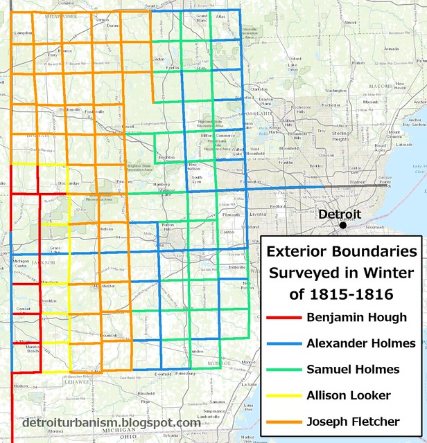
Government surveyors wasted little time, starting their work in late September 1815, just three weeks after the Treaty of Springwells was signed (and before it was even ratified by the US Senate). One of these surveyors was Alexander Holmes of Ohio, who was contracted to establish Michigan's baseline, along which Eight Mile Road now runs. Holmes began to survey the portion of baseline along what would become Royal Oak Township's southern border on November 18, 1815, but he gave up soon after crossing the Saginaw Trail. "We have been wading in ice and water for three days and are completely worn out," Holmes wrote in his survey notes, after setting a survey marker a quarter-mile west of today's Woodward Avenue. He and his team took the trail back to Detroit and, after resting, resumed work elsewhere in the region, leaving the baseline incomplete.
The area surveyed that winter was a block of 96 townships all located west of a line that is now Haggerty Road. This meant that the land which the goverment planned on selling would be no less than a 20 mile journey out of Detroit. The Michigan Territory's governor Lewis Cass asked the federal government to continue with a second round of surveys closer to Detroit, which the General Land Office agreed to in July 1816. Royal Oak would be included in this second round of surveys.

The first two areas in Michigan surveyed according to the US Public Land Survey System. Note that Detroit's "ribbon farms" and the Ten Thousand Acre Tract were excluded from these surveys. (randymajors.org)
As part of this second round of surveys, deputy surveyor Joseph Fletcher was contracted to correct and finish the incomplete baseline. His team reached Royal Oak September 24, 1816 and stopped their work for that day after setting a post at what would become the intersection of Eight Mile Road and Livernois Avenue. Fletcher resumed work on the following morning, completing what would become Royal Oak Township's south border and continuing eastward. He reached Lake Saint Clair three days later, completing the baseline on September 28.
The exterior lines of the future Royal Oak Township were laid down the following year by another surveyor, Joseph Wampler. He began February 6, 1817 at what is now the intersection of Eight Mile Road and Dequindre and worked northward, slogging in and out of wet prairies. Wampler's field notes record the first mile surveyed as "brushy prairie land"—and the second as "very brushy prairie land." Conditions improved north of today's Thirteen Mile Road, where Wampler notes "fine rolling land." After this point, Wampler continued to work on the exterior lines of other future townships in Oakland County.
Wampler returned to complete the exterior boundaries of Royal Oak Township, starting at the southwest corner on March 3, 1817, and working northward. The first two miles of the western border were run over "swampy land" and "level wet land," while the fifth and six miles were described as "rich level land" and "rich land." After reaching what would be the township's northwestern corner, Wampler turned east to mark a temporary line for the north border which would be corrected later, according to the standard practice. He stopped for the day after four miles. On March 4, he continued another two miles, where he found that he missed the northeast corner of the townshp by nearly 14 feet. He used this information to calculate how far to move the posts he had set on his temporary line. This method ensured that each township was as square as possible.
With the township outlined, the final step of the surveying process was to divide it into 36 square-mile sections. Wampler started this work on March 7, 1817 at what is now John R and Eight Mile, and finished March 12 at today's Coolidge and Fourteen Mile. Below is a copy of township plat made from Wampler's field notes. In addition to recording the locations of natural features such as swamps, creeks and prairies, this plat prominently displays the Saginaw Trail, which branches into two sections.

Joseph Wampler, Survey of Town 1 North Range 11 East, Michigan (1817)
Click here for the full-size image of this plat.
(General Land Office Records)

Detail from the preceding image.
Although federal surveyors were dividing the land into six-mile-square "townships," the existence of actual township governments or political boundaries was still several years away. What would later become Royal Oak Township was at this time simply designated Town 1 North, Range 11 East because it is in the first row of townships located north of the Michigan Baseline and in the 11th tier east of the Michigan Meridian.
Surveyors were instructed to document in their field notes certain natural features of the land, including any trees that stood on survey section lines. While running the line which is now Main Street north from Eleven Mile Road on March 8, 1817, Wampler's notes record a black oak 30 inches in diameter, standing 54.32 "chains" (about 3,585 feet) distant from the last section corner.

Joseph Wampler's field notes for the subdivision of Town 1 North Range 11 East record "B. O. 30 in. dr." (a black oak, 30 inches in diameter) standing on the line 54.32 chains north of the corner common to sections 15, 16, 21 and 22.
(Archives of Michigan)
According to Michigan State University, there are ten species of oak trees native to Michigan, which fall into two categories, red and white oaks. The black oak (Quercus velutina) is the second-most common type of red oak in the state.

A mature black oak (Quercus velutina).
Image courtesy Sandra Richard via Flickr.
Using Google Earth to measure 54.32 chains north of the intersection of Main Street and Eleven Mile Road, the black oak in Wampler's field notes appears to have stood just north of the intersection of Crooks Road. Although it's impossible to be sure, this may be the very tree from which Royal Oak would later derive its name.

The Lewis Cass Myth
Who exactly gave the Royal Oak tree its name, and when? The most popular legend credits Lewis Cass. The story goes that Cass and a party of explorers, while venturing into Michigan's interior, stopped to rest on a ridge of high, dry ground, beneath the shade of a great oak tree. The earliest known version of this story comes from Samuel W. Durant's 1877 History of Oakland County, Michigan:
The spot which they had chosen was a smooth, open space under the spreading branches of an oak-tree of larger size than its neighbors, and which the surveyors had made still more noticeable by marking its trunk with a large letter H. The feeling of relaxation was delightful to the amateur explorers after the severe toil of the day's travel, and the conversation which ensued was entertaining and brilliant. It could not be otherwise, for it was led by Lewis Cass. As the governor lay upon the ground and looked up into the matted foliage of the tree-top, he thought of that royal oak in Scotland, among whose sheltering, branches Prince Charles, the Pretender, hid his sacred person from pursuing enemies after the bloody battle of Culloden, and it seemed to him that it must have been just such a tree as this; so they christened it the Royal Oak, and it was from that fanciful thought that the name was given to both tree and township.
(History of Oakland County, Michigan p. 236-237)

Detail from The Naming of Royal Oak (1934) by Andrew Maglia.
(Royal Oak Schools)
In a later telling of the story, Governor Cass falls asleep beneath the tree, and upon awakening the following morning, looks up and remarks, "O what a Royal Oak." ("Millions in buildings will mark Royal Oak centennial." Detroit Free Press, Jan. 15, 1922.) Or, in another version: "This truly is a royal oak." ("Royal Oak's naming." Detroit Free Press, Aug. 24, 1921.) But Durant's 1877 account is the earliest one I could find.
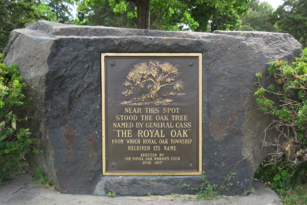
This boulder and tablet are located 164 feet southeast from the calculated location of the oak indicated in Wampler's field notes. The text reads: "Near this spot stood the oak tree named by General Cass 'The Royal Oak' from which Royal Oak Township received its name / Erected by the Royal Oak Woman's Club June 1917."
(Photo by Paul Sewick)
When did this event supposedly take place? Durant places it during "a tour of observation and discovery" of Oakland County, "accompanied by Hon. Austin E. Wing and two or three other friends." This apparently is a reference to a well documented event which occurred in the autumn of 1818. The federal government was set to begin selling land north of the baseline, and west of what is now Hayes Road, on November 2, 1818. Curious about what the interior lands were really like, a group of recent transplants to Detroit banded together to travel up the Saginaw Trail and inspect the lakes area of present-day Oakland County. All five were East Coast men who had moved to the city within the last three years. They were: David C. McKinstry, born in Hillsdale, New York, arrived in Detroit 1815; Austin E. Wing, of Conway, Massachusetts, arrived 1815; Benjamin Stead, of Leeds, England, arrived 1815; John Monteith, of Gettysburg, Pennsylvania, arrived 1816; and Andrew G. Whitney, of North Carolina, arrived 1817.
The McKinstry party embarked on their twelve-day expedition on Monday, October 12, 1818. An account of their travels, entitled A view of some of the lands in the interior of the Territory of Michigan, was published in the November 13, 1818 edition of the Detroit Gazette—a newspaper founded the previous year "with the avowed purpose of extolling the virtues of Michigan and attracting immigrants." (Russell E. Bidlack, Judge Woodward's "Narrative of a Recent Exploring Party in the Territory of Michigan") The report focuses on the quality of the land for farming and the availability of natural resources that would be of interest to homesteaders.
Contrary to Durant's claim, the Detroit Gazette article nowhere states that Lewis Cass was part of the group. The second sentence of the report begins, "We the undersigned, who composed that exploring party..."; but Cass is not among the five names listed at the end.

The beginning and ending of the report published in the Detroit Gazette of November 13, 1818.
(Google News Archive)
Although the 1818 report doesn't say anything about Lewis Cass or the Royal Oak tree, the group did travel through the Royal Oak area and had some observations to make. In the first reference to the Royal Oak area, the report states: "[At] a distance of about twelve miles from this city you come upon while oak ridges affording excellent ground for roads." The second reference describes the party's approach to the Royal Oak area:
We there came into ridges of oak land interspersed with prairies covered thickly with high grass. In these prairies arises a branch of the Red Run. At about 10 miles we crossed a small stream of excellent clear water, which circumstance in this dry season proves it to be a permanent stream. The soil is good and will be excellent wheat land. It is thinly timbered with lofty white Oak. After passing through these lands about 4 miles further we came to another small branch of the Red Run, about which there are some fine bottoms.
The branch of the Red Run with the "fine bottoms" is now Vinsetta Boulevard, and the stream now runs underground. The Saginaw Trail crossed here north of what is now Twelve Mile Road between Woodward and Crooks avenues. At this point in their journey, the group has already passed by the Royal Oak tree without mention. If they did in fact come near or see it, the tree wouldn't have been marked with an "H" yet, as that marking appears to have been part of a territorial road survey that took place the following year. (More on this in a moment.)
Their account of the Royal Oak area, north of the Twelve Mile Road line, continues:
There we came into land considerably undulated, soil pretty good; timber Aspin, Oak, Maple, Sugar, Ash, Elm, Beach, Ironwood, Cherry, chiefly of small size. This was in range 11 E. Township 1, sections 8, 9, 5, 4. In section 6 we encamped & viewed the lands in the neighborhood. Here is another small branch of the red run [sic]. No water at present, but by digging one foot in the channel, we got good water. The banks are elevated, stone sufficiently abundant for ordinary purposes. Some of the land would in the state of Ohio be considered first quality—more of it second. Upon the whole it will admit of excellent farms.
Despite the legends about sleeping beneath the branches of the Royal Oak, this group distinctly reports camping in section 6, more than two miles away. On the following day, they left the Royal Oak area, traveling due west.

"During the early summer of 1818 the first white men to systematically explore this region, camped near this spot on the first night they spent in what is now Oakland County. These men were: D. C. McKinstry, Benjamin Stead, John Monteith, A. G. Whitney, Austin E. Wing. Erected in 1948 by the Royal Oak Historical Society."
(Photo by Paul Sewick)

(Photo by Paul Sewick)
The Royal Oak Historical Society placed the above-pictured plaque in Pioneer Park in 1949. ("Historic spot recognized in Royal Oak." Detroit Free Press, May 8, 1949.) Despite its claim that the McKinstry group were "the first white men to systematically explore this region," that distinction goes to the government surveyors who had been hard at work out in the field beginning in the autumn of 1815. Using the surveyors' meticulously prepared plats as their guide, the "explorers" headed north into what is now West Bloomfield Township, where they
came to a cluster of lakes which are the sources of the Rouge & Huron [Clinton] rivers. As we knew of no names that they had hitherto received, we thought it expedient to give them some, and designated most of those we saw by the names of the explorers. (Emphasis added.)

The 1818 Excursion into Oakland County. This map depicts that part of the explorers' path through what is now West Bloomfield Township, Waterford Township, the City of Pontiac, and Bloomfield Township. (Russell E. Bidlack, Judge Woodward's "Narrative of a Recent Exploring Party in the Territory of Michigan")
The report lists five lakes named for its respective authors—but seven others are named as well. In order of mentioning, they are: Sibley, Canfield, Macomb (after Alexander Macomb), Catherine (after Mrs. Macomb), McDougall, Cass, and Elizabeth (after Mrs. Cass). Naming lakes after Cass and Macomb might be interpreted by some as evidence that these men were present at the expedition. However, it has been documented that Cass left Michigan on August 17, 1818 to attend several treaty signings at Saint Marys, Ohio, and he did not retun until October 13, the day after the explorers departed. Further, the Lewis Cass Papers at the University of Michigan include a letter from Macomb to Cass, dated October 20, 1818, regarding the purchase of an enslaved woman named Sally—written during the October 12-23 expedition. If both men were present at this expedition, it would seem ridiculous for one of them to write the other a letter at this time.
The McKinstry party wasn't the only expedition up the Saginaw Trail that season. According to an 1872 paper by Thomas J. Drake on the history of Oakland County, "In the early part of the fall of 1818, Major Oliver Williams, Calvin Baker, Jacob Eilett, and some others, among whom, it is believed, was Colonel Beaufait, resolved to penetrate into the interior and ascertain whether the country was or was not inhabitable." He mentions "their great gratification" at having "reached the plains beyond Royal Oak," but does not mention this area after that. Drake is also careful to point out, "It is not to be presumed that this party was got up without the knowledge of Governor Cass, but it was entirely without his aid or influence, except to wish the adventurers God speed." (Michigan Historical Collections 3:565-566)
If Cass did have an opportunity to name the Royal Oak tree, the City of Royal Oak's website suggests a more plausible occasion. The version of the story which appears on the page "How Royal Oak Got Its Name" begins:
The year was 1819. Territorial Governor Lewis Cass and his crew left Detroit on horseback to a rendezvous that would result in the Saginaw Treaty. Stopping for lunch, they encountered a remarkable oak tree.
The account continues similarly to Durant's 1877 telling and then concludes:
It is said that Cass delivered his history lesson while lying on the ground, gazing up at the majestic tree that was providing a marvelous ambiance for their luncheon. In awe, he reportedly exclaimed, "This truly is a Royal Oak."
It is actually true that in 1819, "Cass himself, with his staff, secretaries, interpreters and other attendants, came from Detroit on horseback, following the Indian trail by way of Pontiac, Flint, Pe-on-i-go-wink, (Ne-ome's Village, now Taymouth [Township])" in order to negotiate the Saginaw Treaty. (Fred Dustin, The Saginaw Treaty of 1819, p. 9) It has been documented that Cass and his men left Detroit on September 13 and returned on the 28th. But did Cass actually name the Royal Oak on this trip? If so, no historian recorded the story until Durant in 1877, 58 years after the alleged event.

(issuu.com)
If Cass did not name the Royal Oak, then who did? The answer will be revealed in the following section.
The Territorial Road
On November 5, 1818, just three days after the first land sales in present-day Oakland County were opened, a group of local investors formed the Pontiac Company in order to establish a new town in this land. In addition to well-known Detroiters such as William Woodbridge, Stephen Mack, and Solomon Sibley, the company also included four of the five October 1818 expedition members: McKinstry, Wing, Stead, and Whitney. They purchased a site where the Clinton River crosses the Saginaw Trail, 25 miles northwest of Detroit. The future Royal Oak Township would lie directly between those two settlements.
The following month, the territorial government decided to invest in an improved road between Detroit and Pontiac to replace the Saginaw Trail. "An act to establish a certain road," passed December 7, 1818, empowered Governor Cass to establish a public highway by making it a continuation of Woodward Avenue, and to appoint a committee of three to determine the best route beyond that. Cass selected Levi Cook, Ezra Baldwin, and John Hunt for the job. Assisted by the territory's official surveyor, Horatio Ball, they blazed straight lines through the forest, in stark contrast to the winding footpath that had served since time immemorial.
The commissioners delivered their report to Cass one year later, on December 13, 1819. Approving their plan, Cass issued an official proclamation two days later, legally declaring the road as described in the document to be a public highway. However, the line which Ball surveyed does not exactly correspond to today's Woodward Avenue, but deviates about 12 miles from the point of beginning, as described in the legislation:
...thence westwardly to a large Oak Tree, standing on the Right of the Saguinaw [sic] trail so called, and within a short distance of the same, the said Tree being marked with the Letter H. Thence westwardly in a direct Line as surveyed and marked by Horatio Ball to the Main Street in the Village of Pontiac, and thence along said Street to its termination.

The locations of the 1819 territorial road and today's Woodward Avenue superimposed over Wampler's 1817 plat.

The path of the original territorial road over a modern satellite image.
Oakland County pioneer and judge Thomas Drake, in his history of the county delivered to the Wayne County Pioneer Society five years before Durant's history was published, wrote this about Cass's territorial road proclamation:
The origin of the name given to this town may not be known to many, and it will soon pass beyond recollection. On the 15th of December, 1819, Governor Cass, by proclamation, established a road which had been previously run out by commissioners which he had appointed for that purpose, from a point on Woodward avenue, in the city of Detroit, to the end of the road built by the United States troops; thence westerly along a line run by Horatio Ball to the Main street in Pontiac village; thence along that to the end thereof. This was the first road leading into the interior. The tree was near the line run by Ball; and probably was marked H on that occasion. It stood on the plains, on the north and east side of the Indian trail which led from Detroit to Pontiac, by Chase's. The tree was of some magnitude, and, after the issuing of the proclamation, became an object of observation and was called, by way of distinction, the 'Royal Oak,' and soon the name of Royal Oak was applied to that portion of the country, and was given to the town at its organization.
(Michigan Historical Collections 3:568-569)
This passage never says that Cass named the tree, nor does his proclamation contain the phrase "Royal Oak". However I believe that Samuel Durant, in preparing his 1877 history of Oakland County, read Thomas Drake's 1872 paper quoted above, and either by misinterpretation or poetic license wrote the legend that has been passed down to this day.
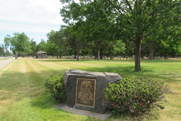
The "Royal Oak Tree" plaque, located by the entrance to Oakview Cemetery.
(Photo by Paul Sewick)
The tree was mentioned in some of the memoirs of the pioneers who immigrated to Michigan in the 1820s, including Harvey C. Parke, who came in March 1821 in order to engage in surveying work. In a paper read before the Oakland County Pioneer Society in 1874 and 1876, Parke recounted his arrival in Detroit and his journey up the new territorial road:
At the angle of the road, twelve miles from Detroit, we passed the Royal Oak tree, which had nothing remarkable in its appearance, but was known as the point from which Horatio Ball had started the line when surveying the road to Pontiac, known as the Ball line road.
(Michigan Historical Collections 3:574)
Arriving five months after Parke was another pioneer, Stephen van Rensselaer Trowbridge, whose journey would also take him up the territorial road. Printed in the May 1, 1858 edition of the Pontiac Gazette under the title, Reminiscences of the Early Settlement of Michigan, Trowbridge recalled, after spending a night at a crude roadside tavern:
Next day started in good spirits on a firm road for a few miles, and came to the Royal Oak tree—a tree named by John J. Hunt, Ezra Baldwin, and David McKinstry, Commissioners to run a road to Pontiac. The tree was named by Judge John J. Hunt. The other gentlemen had stuck the stake near this tree, and Judge Hunt said "we will call this the Royal Oak."
Trowbridge himself was an early pioneer of Troy Township, located just north of Royal Oak, where he lived the rest of his life. Having seen the tree in person and writing down his account nearly 20 years before Durant published his version, this is the most reliable account we have for the naming of the Royal Oak tree.
Like so many prominent Detroiters in this period, John Hunt was a recent newcomer from the eastern states, having arrived in 1818, the same year that Cass appointed him as one of the territorial road commissioners. He practiced law in Stockbridge, Massachusetts before coming to Detroit, where he established a partnership with Charles Larned. In 1820, he was elected to the Detroit board of trustees, which was similar to a city council. Four years later, President James Madison appointed Hunt one of three judges of the Michigan Territory. Following a bitter libel suit against the Detroit Gazette in 1825 and the death of his wife in September 1826, he experienced a severe decline in his mental health, suffering debilitating delusions. While traveling back east, Judge Hunt died in Whitesboro, New York on June 17, 1827.
Early Pioneers
The Royal Oak area was not an ideal location for farming. The best soil reported by government surveyors at this time was in present-day Livingston and Shiawassee counties. Being largely covered with dense, swampy forests and open wetlands, Royal Oak was mainly a place for Michigan's immigrants to pass through rather than settle down. From the opening of land sales in November 1818 through the end of 1822, the US Land Office in Detroit only sold seven parcels of land in "Town 1 North Range 11 East."
The very first sale occurred February 27, 1819, when William Thurber made a deposit on the northeast quarter of section 6. Several months later, on June 4, Thurber did the same for the northwest quarter of that section. The Saginaw Trail passed through both parcels, which are located in the very northwest corner of Royal Oak. Thurber was not merely a speculator, but did in fact build a cabin and live on this land. (Michigan History Magazine 13:496) These first purchases were approximately where the McKinstry party camped on the first night of their excursion.
David McKinstry himself, along with "L. Luther," made the next purchase just over a year later, on June 6, 1820. They claimed the southeast quarter of section 33, at the very southern end of the township, where the Saginw Trail crossed the baseline. This was the only purchase in Royal Oak made that year. A shoemaker named Jabez White leased this land and built a cabin on the Saginaw Trail at the center of this quarter-section, naming his estate "White's Place."

Locations of first private land sales in the area that was to become Royal Oak Township.
Thomas Drake's county history explains how purchasing federal land worked at the time:
At the opening of the land office in Michigan the public lands were offered at auction. Such as were not bid off were subject to sale thereafter at two dollars an acre, one-fourth of which was to be paid at the time of entry, the balance in one, two, and three years, with interest. All the lands which were sold previous to July 3d, 1820, were sold under that rule. On the 23d of April, 1820, Congress passed an act authorizing the sale of all public lands at one dollar and twenty-five cents an acre, full payment at the purchase. This was a great event in the history of Michigan, and indeed of that of the whole western country. It put an end at once to that system of vassalage under which the purchaser of public lands had labored; the purchaser became at once the absolute owner of the soil.... (Michigan Historical Collections 2:419)
Sales in Royal Oak remained slow for a time. Henry Stephens of Monroe County, New York purchased 80 acres on the Saginaw Trail in section 33 on June 13, 1821. Hezekiah Gridley of Oakland County and Alexander Campbell of Detroit made purchases that autumn. Henry Stephens purchased another 80-acre parcel the following year.
Purchases increased in 1823 with 21 sales—three times the total number of parcels sold before that point. Local buyers claimed ten of these sales, but the remaining purchasers all hailed from three contiguous counties in western upstate New York, including Henry Stephens of Monroe County, Jonathan Voorhies of Seneca County, and five men from Ontario County: Justus W. Toms, James G. Johnson, David Williams, John Evans, and Harris Wilson.
 Public land sale entries of 1823 in Town 1 North Range 11 East.
In mapping these first land entries, the underlying geology of Royal Oak reveals itself—particularly the ancient beach ridge formed approximately 12,500 years ago when Detroit was covered by the waters of Lake Wayne. The high, well-drained, sandy soil along this ridge was far more desirable than the swampy and thickly-timbered areas which once lay on either side of it.
The map below superimposes the first 28 land sales in the Royal Oak area over a map of the land's geological features.

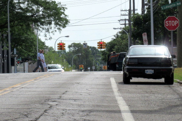
The shape of the underlying beach ridge which runs through the Royal Oak communities shows itself when viewing Lafayette Street from Sixth Street in the City of Royal Oak. The Saginaw Trail once ran along the top of the ridge here, in the southeast quarter of section 21.
(Photo by Paul Sewick)
As the best parcels of land were purchased first, sales within the Royal Oak area began to drop. Following the 21 purchases in 1823, in 1824 there were 12; in 1825, 8; in 1826, 6; in 1827, 3; in 1828, 2; and only one in 1829. Sales would pick back up in the 1830s with the growth of a real-estate bubble that contributed to the Panic of 1837.
Rochester Road
A steady flow of homesteaders into the territory meant an increased demand for passable roads. Although the territory itself lacked the funds to build them at this time, the government allowed private companies to establish toll roads. On August 5, 1824, the territorial government passed An Act to incorporate the Pontiac and Paint Creek Turnpike company. This corporation was permitted to establish a turnpike on the territorial road between Detroit and Pontiac, beginning on Woodward Avenue around where Grand Boulevard is today. This company was also allowed to establish "a branch of the said turnpike, to commence from a point, as near as may be convenient and practicable, to the Royal Oak, so called, about twelve miles from the river Detroit, and extending thence, by the nearest and most practicable route, to a point on Paint Creek...." (Laws of the Territory of Michigan 2:212) The "point on Paint Creek" refers to the village that would become today's City of Rochester, and this route has since become Rochester Road.

Detail from Orange Risdon's Map of the Surveyed Part of the Territory of Michigan, published in New York in 1825 for people interested in buying Michigan land. (University of Michigan - Clark Library)
Henry O. Bronson, a pioneer already living near the Rochester village site, acquired land in Royal Oak near the branch in the turnpike in 1825. Clearly aware of a business opportunity here, Bronson bought the west half of the southwest quarter of section 15 and constructed Royal Oak's first tavern just south the Royal Oak tree. Located 12 miles outside of Detroit, Bronson's tavern was a convenient resting place for land seekers entering the territory.

Detail from Orange Risdon's 1825 Map of the Surveyed Part of the Territory of Michigan, showing Town 1 North Range 11 East. The area was not yet known as Royal Oak; it remained part of Bloomfield Township when this map was published. An original copy of the Risdon map is on public display at Farmington Hills City Hall. (Photo by Paul Sewick)
First Post Offices
By the mid-1820s, there were enough settlers to warrant a post office. James Lockwood, who had purchased two "quarter sections" near the center of the township in 1823, was appointed the first postmaster for the Royal Oak area April 6, 1826. He operated the post office out of the log tavern he constructed on the Saginaw Trail, about where Washington Square Plaza stands today. (Charles Fey, The City of Royal Oak, Michigan, 1817-1954, p. 230) After just five months, he sold the property to Samuel Torbert, who became postmaster September 21 of that year.
Following Torbert was Joseph Chase, who had purchased the west half of the northwest quarter of section 9 in 1824. After Chase was appointed Royal Oak's postmaster on January 21, 1830, he relocated the post office to his property at what is now the intersection of Crooks Road and Thirteen Mile Road. The post office remained at this place, known as "Chase's Corners," until 1841.
Woodward Avenue
It was also around this time that Woodward Avenue began to follow its current path through the Royal Oak area. In 1827, the US Congress passed a law authorizing the President of the United States to appoint three commissioners to survey a road between Detroit and Saginaw. The commissioners—one of whom was David McKinstry—submitted their report June 9, 1827. In December 1828, the House of Representatives asked the Secretary of War to report on the cost of completing the road and his opinion regarding its military importance. The report was made to Congress within a few weeks, supporting the road's construction, and Congress appropriated $10,000 "for completing the road from Detroit to Saganaw [sic]" on March 2, 1829.

Brigadier General Charles Gratiot, Chief Engineer of the US Army, reported in November 1829, "The construction of fifteen miles and a quarter of this road has been contracted for and is in progress." (This point on the road would have been a little north of the Thirteen Mile Road line.) In May of 1830, Congress approved an additional expenditure of $7,000. Gen. Gratiot's report for 1830 noted that "seventeen and a half miles (have) been completed." The first version of Woodward Avenue following the path that we know today had been constructed through and beyond Royal Oak.
The Founding of Royal Oak Township
The following is a time line of changes to county and township borders which have affected the Royal Oak area since the time of US occupation:
- August 15, 1796—Wayne County is established in the Northwestern Territory, including the future site of Royal Oak.
- February-March 1817—Joseph Wampler surveys Town 1 North, Range 11 East.
- January 15, 1818—A vast area north of the baseline is declared to be Macomb County.
- January 12, 1819—Governor Cass announces that Oakland County would be created from a part of Macomb County.
- March 28, 1820—Oakland County is actually created.
- June 28, 1820—The county is divided into two townships, Oakland and Bloomfield, the latter containing the Royal Oak area.
- April 12, 1827—Oakland County is reorganized into five townships: Oakland, Bloomfield, Pontiac, Farmington, and Troy—the last including Royal Oak.

The borders of Oakland County's townships following an act of April 12, 1827. Royal Oak Township was later formed from the southern half of Troy Township at the southeastern corner of the county.
(Archive.org)
The Royal Oak Township finally became an independent entity as a result of a state law which separated Town 1 North Rage 11 East from Troy Township. Acting Territorial Governor Stevens T. Mason signed An Act to organize the townships of Royal Oak and Novi in the county of Oakland on June 9, 1832. As written in the law, Royal Oak would officially become a township on March 31, 1833.
These are the events which led up to Royal Oak Township's establishment in 1833. The next phase of development centered around Sherman Stevens' founding of the Detroit and Pontiac Railroad in 1834. Stevens purchased 120 acres in the middle of the township in 1836, where he constructed a saw mill for the railroad. On this land he platted a village in 1838, the nucleus of what was to become the Village of Royal Oak, legally incorporated in 1891. These events, and later annexations from Royal Oak Township, may be the subject of future articles.

Detail from An Improved Edition of A Map of the Surveyed Part of the Territory of Michigan by John Farmer, published in 1835, with Royal Oak Township highlighted.
(raremaps.com)
Thanks for this. I’m going to enjoy it. I thought that you were working on something good. Blending natural history and settlement and helping to make sense of place. Great contribution.
ReplyDeleteGreat article, Paul! I really appreciate the way you show how geography shaped settlement in an area it's all too easy to think of as flat and featureless. One question - I'm curious what you make of John Farmer's 1826 map of Michigan showing a route parallel to Ball Line Road, apparently on the modern path of Woodward. Do we know of any improvements on that route prior to the 1827 law? The second route is distinctly recorded as a road, rather than a trail like you'd expect if Farmer was indicating the original Saginaw Trail.
ReplyDeleteThat's a good question! The honest answer is, I think I'm missing some information here. I believe there have been efforts to straighten Woodward Avenue beyond the bend at what is now Lafayette Avenue before the military road law was passed. According to a paper read before the Historical Society of Michigan by Charles Trowbridge in May 1864, "As late as 1822 or 1823, large parties of farmers made a bee to construct a causeway across the cranberry marsh [around Eleven Mile Road]. They erected a commodious log shanty there, and spent several weeks in making the marsh passable." (Michigan Historical Collections, vol. 1 p. 381) If any local or territorial laws officially straightened Woodward/Saginaw here, I think I just may not have come across it yet.
DeleteGreat to see another post up! This blog helped inspire my own journey into Detroit area history which continues today!
ReplyDeleteIf you are into the urbanist activist scene. Strong Towns has a Detroit chapter that you may enjoy. I just found it recently myself. strongdetroit.org
Hey, glad to see your back!
ReplyDeleteQuick question, you mention Joseph Fletcher starting the survey of the southern boundary of the township on Sep 24, 1816. Why is Joseph Wampler mentioned in the graphic below that paragraph showing the dates of Sep 24 and Sep 25? What is this showing us? I see some circles in white and others gray. September 25th is not mentioned in the paragraph nor is Joseph Wampler, who doesn't show up to the following year.
The graphic had a typo. I meant to say Fletcher and I typed Wampler instead. Wrong Joseph! I have removed the image. Thank you for pointing this out!
Delete"As part of this second round of surveys, deputy surveyor Joseph Fletcher was contracted to correct and finish the incomplete baseline. His team reached Royal Oak September 24, 1816 and stopped their work for that day after setting a post at what would become the intersection of Eight Mile Road and Livernois Avenue. Fletcher resumed work on the following morning, completing what would become Royal Oak Township's south border and continuing eastward. He reached Lake Saint Clair three days later, completing the baseline on September 28."
ReplyDeleteI'm also not sure what this means. Where did Fletcher start and what was the unfinished part of the survey; the part east of Haggerty? Was he working from Haggerty East? Was Alexander Holmes working east or west in 1815, and from what?
BTW:
https://live.staticflickr.com/65535/54847372919_cf4b435021_o.jpg
I do not know why the shapefile for cities in Michigan still show the "islands" in Oak Park, but those were part of a "425 Agreement" (a time-limited transfer of territory) back in 2003 or 2004, and became part of Oak Park. I figure what happened is that you have to report boundary changes to the Census (and the state) to have correct boundaries show, and they simply never did it. Someone may want to tell them to correct the records. lol
Fletcher was completing the work that Alexander Holmes left incomplete when he gave up in November 1815. Fletcher re-surveyed the baseline starting from Haggerty, working eastward.
DeleteAnd there are still islands of unincorporated Royal Oak Township lying within Oak Park. I don't know the details beyond that, but it would definitely be an interesting future research topic!
Thanks, again.
DeleteOh, I was talking specifically about those parts of the township shown in the northwest part of Oak Park. Yes, there is still a tiny section of the township along Eight Mile. But those sections acround 696 all got brought under Oak Park's jurisdiction by 2006, most of them by 2004.
Do you know where I can find the legal descriptions of the individual parcels that were part of that arrangement?
DeleteA slight correction, two elections happened one in Aug 2003 and one in Nov 2004.
DeleteI can tell you that Rue Versailles and Lincoln Towers Apartments as well as the Crowne Pointe office building were annexed on Aug 5, 2003. Parcels numbers for that one can be found, here, though Parcels 5 & 6 - which I believe are the Lincoln Towers and an adjacent parcel - are only given descriptions:
https://www.legislature.mi.gov/documents/publications/Mpla/2003/09-BoundaryProceed2003.pdf
The 2004 annexation, which annexed the rest are also just descriptions, and kind of confusingly written with exceptions:
https://www.legislature.mi.gov/documents/publications/Mpla/2004/10A-CitiesBou_aryProceed200.pdf
https://www.legislature.mi.gov/documents/publications/Mpla/2005/10A-CitiesBou_dProceed-2005.pdf
I'm also unsure why there is a 2004 and 2005 file for annexations which happened in 2004; it'd may be a correction. But oddly, the 2004 gives an effective date of October, which would have been before the 2004 vote on the remainder of this section of the township, so perhaps its a correction for the description of the 2003 annexation?
It was really quite a mess. The city didn't even want one of the properties (Bridgewater Apartments) off Greenfield north of the freeay, but voters in both voted to annex it anyway.