
Following the great fire of 1805, the US Congress passed "An act to provide for the adjustment of titles of land in the town of Detroit and Territory of Michigan, and for other purposes" on April 21, 1806. This law allowed the territorial government to "lay out a town, including the whole of the old town of Detroit, and ten thousand acres adjacent." Every adult citizen of the town received a lot on the new plan. When this was accomplished, the "land remaining of the said ten thousand acres" was to be sold, and the funds applied "towards building a courthouse and a jail in the town of Detroit." The 10,000 acres were surveyed in two phases. The first phase, consisting of less than 500 acres, included the land north of Adams Avenue and between the Cass and Brush farms. This area would become the Park Lots. The second phase, which will be covered in a future article, became known as the Ten Thousand Acre Tract.

By 1808, the Michigan territorial government was prepared to begin the first phase of land disposal. Naturally, the Woodward Plan should have been continued north of Adams Avenue, and the land should have been sold as individual city lots. However, Judge Woodward was absent from the territory in late 1808 and early 1809, and his enemies were eager to abolish his Utopian street plan. In November 1808, Governor William Hull, Judge James Witherell and Deputy Surveyor James McCloskey conspired to institute a new plan of rectangular blocks, but the proposal failed to garner public support. Undeterred, Hull, Witherell, and McCloskey focused their attack north of Adams Avenue. They decided that this area would not comply with the city plan, but instead be chopped up into small farms ranging in size from five to ten acres. On December 14, 1808, the Michigan territorial government (which consisted of the Governor and Judges of the territory, who also sat as the Detroit Land Board) passed the following resolution:
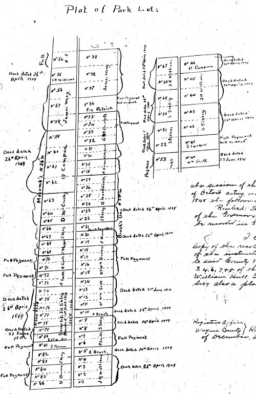
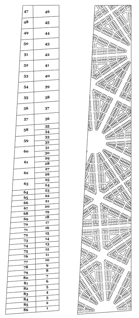
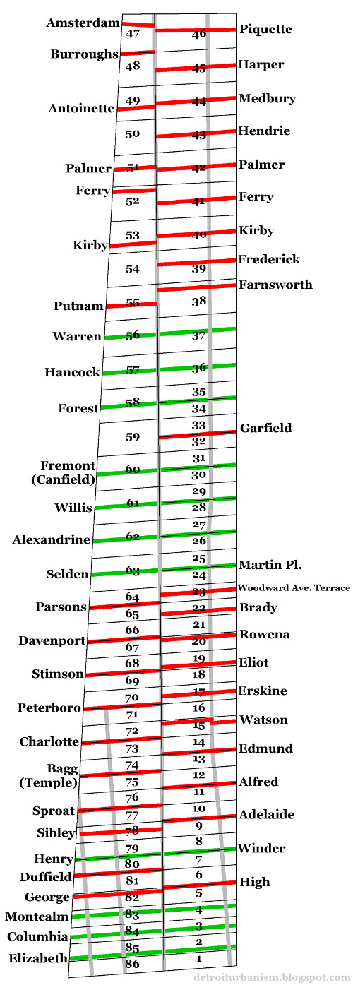
Ordered that Mr. McCroskey [sic] be requested to survey the lands granted by congress to this Territory, for the purpose of building a jail and court-house, and that he commence his survey northwest of the street [Adams Avenue], which runs thro' the Grand Circus, parallel with the main street ; that he shall there begin with lots of five acres, and increase the size of the lots as he proceeds, that he shall observe such directions, as he shall receive from time to time, from the commissioners, or a majority of them, and that he be entitled to the same compensation, as is allowed by congress to the surveyor of the United States for surveying the public lands of the United States, and that he receive his compensation in the proceeds of the ten thousand acres granted by congress aforesaid.The tract to be divided was a tall, irregular shape, and narrower at the north end than at the south end, due to the way the Cass and Brush farms tilted slightly toward one another. The survey resulted in eighty-six lots divided into two tiers. The line dividing the two tiers was parallel with the border of the Brush Farm, and the east-west lines ran parallel to Adams Avenue. Although all of these lots were irregularly shaped, they were generally classed as being either "five acre" or "ten acre" lots. The fifty-eight "five acre" lots measured 211.53 feet wide, and the twenty-eight "ten acre" lots were 423.06 feet wide. The narrower lots were grouped at the southern end of the plat.
It appears that surveyor Aaron Greely either assisted McCloskey in platting the Park Lots, or that Greely even did the work without him. According to territorial records, Greely was paid $72.27½ in May of 1809 for "surveying and bounding on the domain 86 lots." He was also compensated for drawing up a plat of the lots.
The Governor and Judges, acting as the Detroit Land Board, moved quickly to sell the land in Judge Woodward's absence. On February 20, 1809, they issued a resolution, stating:
Ordered, that on the 6th day of March next, the commissioners [i.e., the Land Board] will proceed to the sale of such five-acre lots, etc., of land as have already been laid off beyond the court house circus [Grand Circus]; and the conditions of payment for the same shall be one-fourth part in cash ; the one-fourth part in six months, and the remaining half in twelve months from the day of the sale.The auction occurred as scheduled on March 6, 1809. William McDowell Scott, a lawyer, acted as auctioneer, and forty-one lots were sold that day.
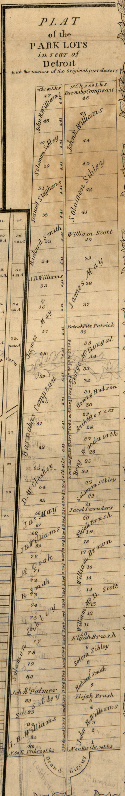
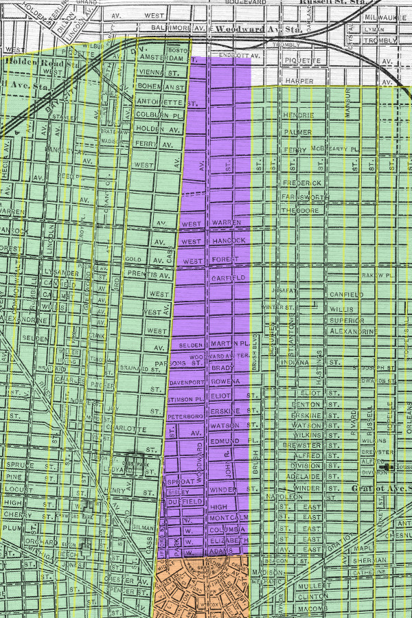
Below is a detail from an 1855 map of Wayne County by surveyor John Farmer, in which the original owners of the lots are indicated.
"Selling the Public Commons"
Judge Woodward returned to Detroit to find his Plan of Detroit disrupted by the Park Lots survey. A road at odds with the plan would inevitably form along the dividing line between the two tiers of Park Lots, but Woodward's legal solution to this problem was to consider that road to be "a lane without a permanent street." He still held out hope that his Plan of Detroit could yet expand into the Park Lots, and he attached the following proviso to the deeds issued for their sale:
That the City of Detroit may extend over [the lot(s)], without [the owner(s)] expecting or claiming any compensation for the avenues, streets, roads, alleys, lanes, squares, circuses and other public spaces and reservations of ground of the said City of Detroit according to the original plan thereof, whenever a majority of the proprietors of any such quantity may desire the same and whenever the same may be required by the competent public authority ; so that no title shall ever be considered as vesting in any individual to such avenues, streets, roads, lanes, alleys, squares, circuses and other public spaces and reservations of ground.Woodward was not alone in opposing the sale of the Park Lots. Citizens of Detroit petitioned the territorial government in 1811, asking that the sales be declared invalid. They argued that, in the 1806 law allowing the Governor and Judges to "lay out a town, including the whole of the old town of Detroit, and ten thousand acres adjacent," the "old town of Detroit" referred to the 1802 incorporation boundaries, which extended two miles inland. Therefore, more than half of the land included in the Park Lots belonged to the Town of Detroit, and could not be disposed of by the territorial government. "Your Honorable Body is still at full liberty to retrace your steps," the petition stated, "and grant to the Inhabitants residing in the Town of Detroit, their Commons, which they have time out of mind enjoyed."
Although the petition failed to restore public ownership of the Park Lots, Woodward did not live to see them subdivided in a way that was at odds with his Plan of Detroit.
Subdivisions
For nearly thirty years following the initial platting of Detroit in 1806, very little land was divided into city lots. The subdivision of the Military Reserve in 1827 was a rare exception. This period of relative quiet came to an end in 1835, when land speculators poured into Michigan and the demand for real estate soared. Multiple tracts of farmland surrounding the city were carved up into town lots that year, including several Park Lots.
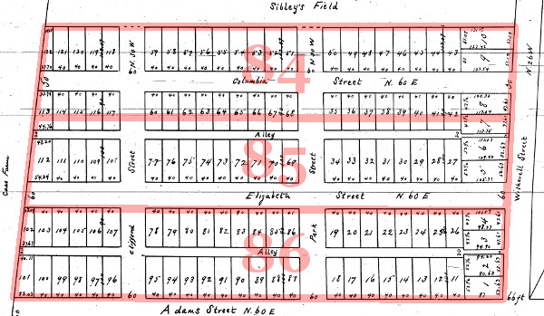
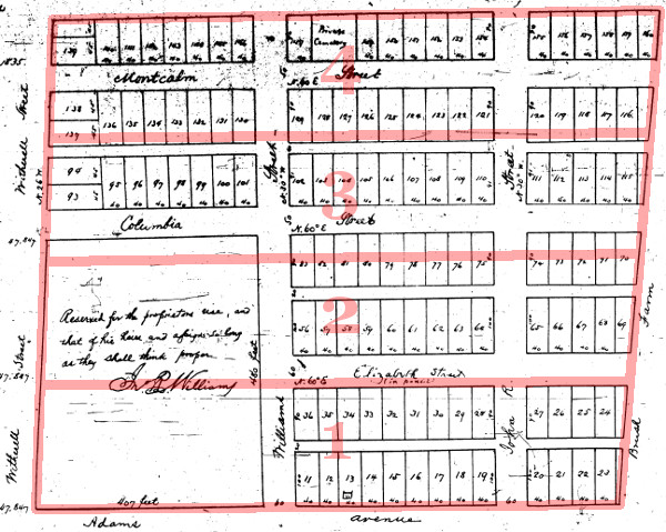
The first Park Lots to be subdivided were numbers 84, 85, and 86, the southernmost parcels on the west half, owned by Dr. William Brown. The plat was prepared by surveyor Anson Earl Hathon and received by the Detroit City Register in May of 1835. Rather than simply dividing each Park Lot into half of a block each, Hathon divided three Park Lots into two and a half blocks. He created two new east-west streets--Elizabeth and Columbia--each of a different width. Lots were not a uniform depth either, measuring either 100 or ninety feet deep depending on whether they were on the north or south side of the street. Lots began at the very south edge of lot 86, narrowing Adams Avenue to sixty feet, half its intended width. The Grand Circus, too, was cut in half, never to be a full circle as originally designed.
Seven months later, Hathon subdivided the southernmost Park Lots on the east side, numbers 1, 2, 3 and 4, submitting the plat to the city on December 12, 1835. Here he continued the same scheme, dividing four lots into approximately three and one third blocks, consisting of blocks of unequal depth and streets of unequal width. The owner of these lots, John R. Williams, withheld an approximately five-acre section from the plat at the northeast corner of Woodward and Adams Avenues. Maps at the time often referred to this parcel as the "John R. Williams Reserve." Hathon's plat contained two new north-south streets named after the proprietor: John R Street, and Williams Street. Only one of those streets still retains its original name.
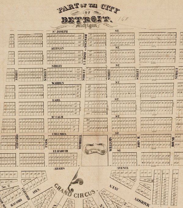
The pattern by which the southern Park Lots were planned to be divided is more clearly displayed on this map published by George Endicott of New York around 1835. But even this plan was abandoned as parcels farther north were broken up into building lots. Note that Woodward Avenue north of the Grand Circus was called Witherell Avenue at the time.
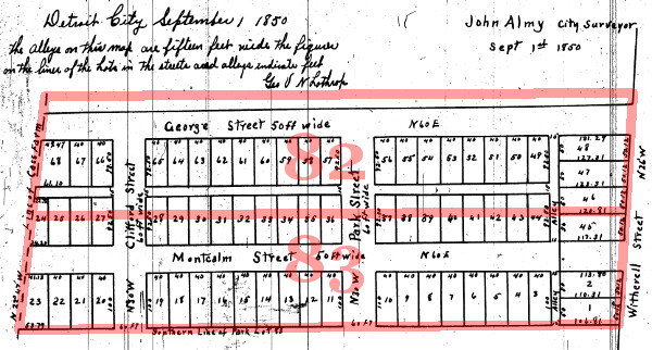
The Panic of 1837 slowed Detroit's growth for some time. It wasn't until 1850 that the next Park Lots, numbers 82 and 83, were divided. The surveyor, John Almy, ignored Hathon's previous plats and created a brand new scheme. (There was no legal requirement to follow any specific plan, and although the local government had to accept a plat for it to be legal, the standards were extremely low.) Almy platted lots 92.5 feet deep and created a new sixty-foot-wide street, George Street. It was named for the lots' owner, George Van Ness Lothrop, as well as the owner of the lots to the north, George Duffield. George Street was renamed High Street in 1874.
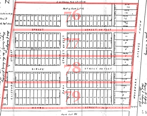
The disparity between Park Lots grew worse with the next group to be subdivided, which were not contiguous with the previous plats. Park Lots 76, 77, 78 and 79--the property of brothers Henry Hastings Sibley and Ebenezer Sproat Sibley--were divided by surveyor John Mullett in September of 1851. The south border of lot 79 became the center line of a new fifty-foot-wide road, Henry Street. But two other new streets, Sibley and Sproat Streets, did not coincide with the borders between the Park Lots. These four lots were divided into two and two-thirds blocks consisting of lots measuring 125.78 feet deep.
The first of the many jogs in the road over Woodward occurred with the subdivision of Park Lot 5, owned by Edmund, Alfred, and Adelaide Brush. City Surveyor Thomas Campau, who drew the plat in April 1852, placed a new, seventy-foot-wide road, High Street, on the north border of the lot. The placement of this street ensured that it would not align with George Street on the other side of Woodward. George Street was renamed High Street in order to unite the two streets despite the awkward jog.
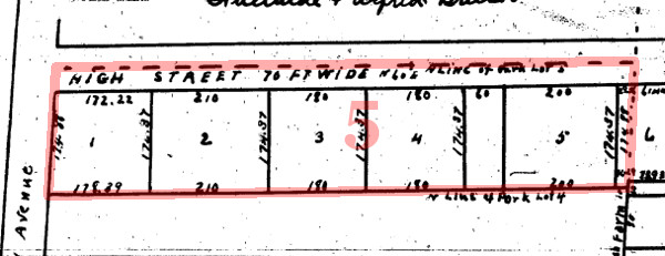
The most straightforward way to subdivide Park Lots would have been to simply lay out streets and alleys over their borders. This wasn't attempted until August of 1852, when Park Lots 6 and 7, owned by John and Martha Winder, were platted by surveyor Anson Hathon in such a way. High Street had already existed on the south line of Park Lot 6, and Hathon drew a new road, Winder Street, on the north line of Lot 7. An alley was drawn directly over the border between the two lots.
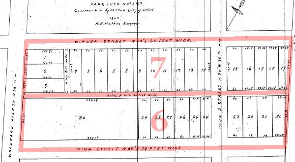
Many more Park Lots were later subdivided using this simple method, but not all. For example, Leander Farnsworth, the owner of Park Lots 38 and 39, drew an alley along the north border of his property, but placed two new cross streets (Frederick and Farnsworth) more or less arbitrarily below it.
Even worse was the Brush family. In 1871, they subdivided Park Lots 17 through 21 so that lots facing Woodward Avenue would measure fifty feet wide by 200 feet deep, and that these lots would be grouped into blocks of five and separated by new sixty-foot-wide streets--an entirely new scheme completely at odds with all adjacent subdivisions.
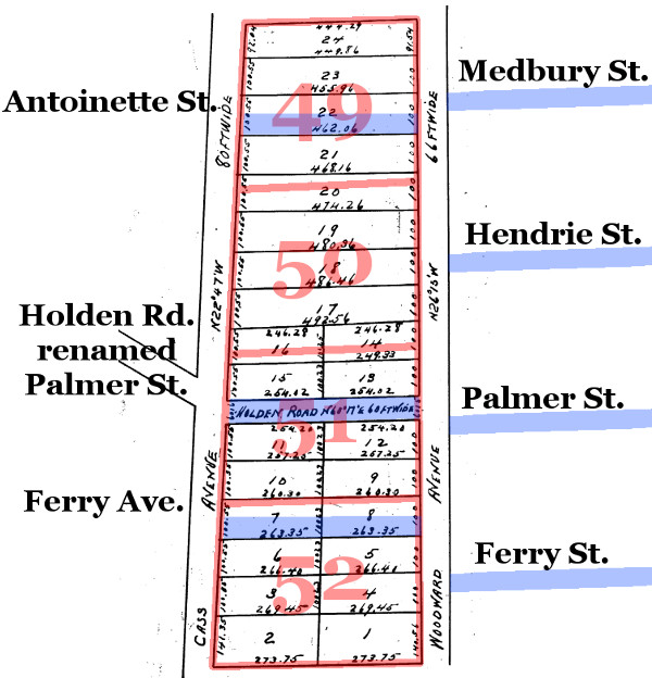
Another problem spot among the Park Lots is the area west of Woodward and north of Warren Avenue. These "ten acre" lots were divided into smaller farm lots in the 1850s and 1860s, and streets later developed along the borders of these smaller parcels. Although the lots across Woodward were more simply divided so that a street ran down the very center of each one, the lack of unity resulted in multiple streets ending at Woodward rather than crossing it. Below is surveyor Eugene Robinson's 1864 subdivision of Park Lots 49 through 52 into twenty-four smaller lots. The locations of present-day streets have been added.
Those who criticize the Woodward Plan as "confusing" have apparently never examined a map of the street system we ended up with instead.
Free-Market Urban Planning
By 1895, the platting of the Park Lots was essentially complete. The folly of abandoning the Plan of Detroit, failing to replace it with something--anything--and leaving the layout of the city up to land speculators--all of these are made manifest in the street grid that resulted. The diagram below shows the streets that had been established by the end of the nineteenth century. Only one-third of the streets that intersect Woodward in the Park Lots cross the avenue seamlessly--these are shown here in green. Streets interrupted by abrupt jogs or that end as T junctions at Woodward are shown in red.
Note that although the streets from Adelaide to Charlotte were simply drawn over the borders between lots, a lack of coordination among subdivisions has resulted in these streets all terminating at Woodward Avenue.
Some alterations were made to these streets in the last century. Martin Place and Woodward Avenue Terrace have been removed, Rowena and Davenport have been widened and joined as Mack Avenue and Martin Luther King Jr. Boulevard, and the disjointed halves of High Street were developed into Vernor Highway. But the cockeyed street grid of the Park Lots remains largely the same today.
Even more disruptions are seen when one follows these streets outside of the Park Lots. Below is a map from 1901 in which the Park Lots have been highlighted in purple, the ribbon farms in green, and the Woodward Plan in orange.
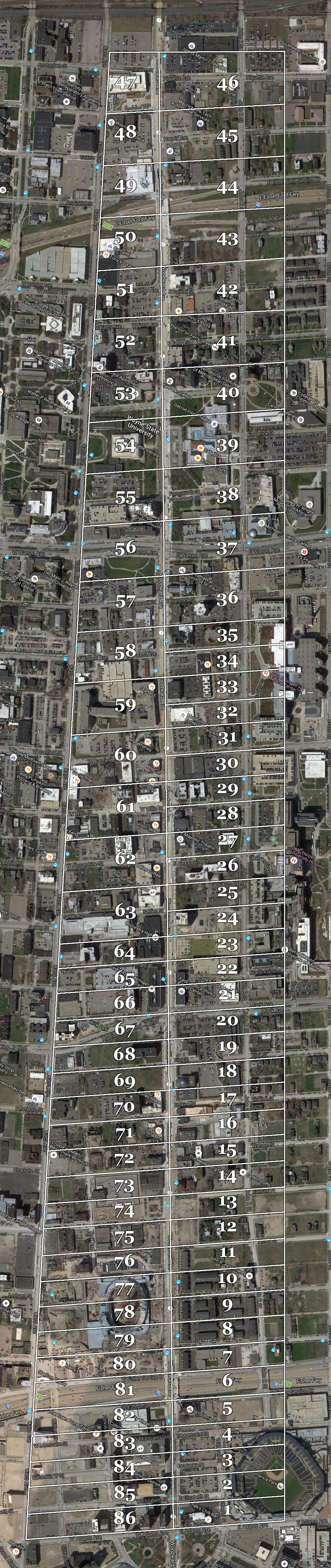
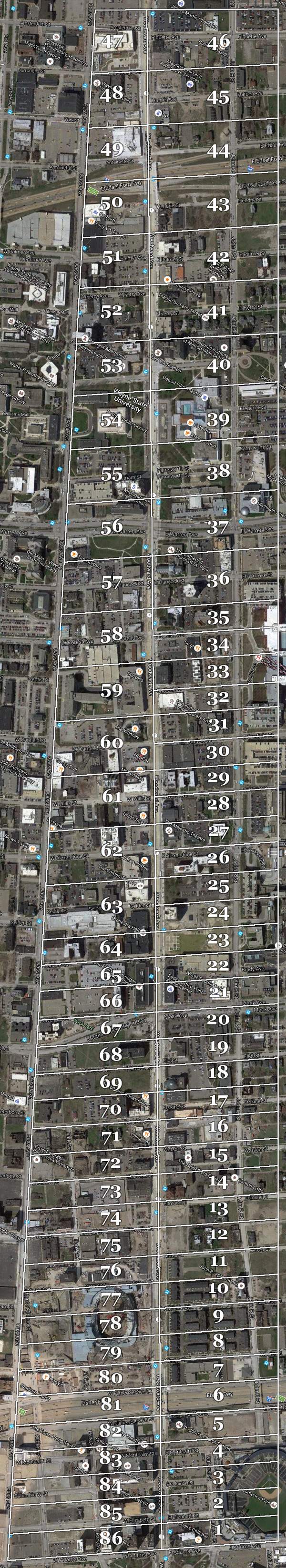
Below is an outline of the Park Lots superimposed over a modern satellite photo. Click here for a larger version of this image.
As we examine the mystery of Detroit's street grid, some pieces of the puzzle fall into place as the origins and the layout of the Park Lots are brought to light. Despite the sometimes chaotic way in which The Park Lots were subdivided, the outlines of many remain preserved to this day by streets and alleys found throughout the Cass Corridor and Midtown. History has proven Augustus Woodward right not only in his prediction that the City of Detroit would grow far beyond Adams Avenue, but also in his warning to the territorial government that the "original ground-plan must remain, and cannot be changed without the height of inconvenience, trouble, and expense." Remember Judge Woodward the next time you're forced to make two awkward turns just to cross the avenue that now bears his name.
This comment has been removed by a blog administrator.
ReplyDeleteSo very interesting! Being in MI for about 15 years and working downtown for the last 7.5, I had always wondered about the disjointed feel off of and to Woodward. Thanks for the depth of research and insight.
ReplyDeleteWonderful research and information which is shared in this great post. The readers would surely like it. Thanks! affordable jfk parking deals
ReplyDeleteSetting out entails that you've got a very good perception within your strategies, topics, thought processes, technique, case, and so on. http://s5nc5povfr.dip.jp http://kul0htng0h.dip.jp https://imgur.com/a/ubzr0Fr https://imgur.com/a/fRaijtj https://imgur.com/a/RX2B87z https://imgur.com/a/l88oVYM https://imgur.com/a/nGN8Lda
ReplyDeleteI'm Абрам Александр a businessman who was able to revive his dying lumbering business through the help of a God sent lender known as Benjamin Lee the Loan Consultant of Le_Meridian Funding Service. Am resident at Yekaterinburg Екатеринбург. Well are you trying to start a business, settle your debt, expand your existing one, need money to purchase supplies. Have you been having problem trying to secure a Good Credit Facility, I want you to know that Le_Meridian Funding Service. Is the right place for you to resolve all your financial problem because am a living testimony and i can't just keep this to myself when others are looking for a way to be financially lifted.. I want you all to contact this God sent lender using the details as stated in other to be a partaker of this great opportunity Email: lfdsloans@lemeridianfds.com OR WhatsApp/Text +1-989-394-3740.
ReplyDeleteMy grandparents lived in the Charles Gauss home that was at 135 High Street, near Cass Tech and torn down by Vernor Highway, as grandma noted. Still looking for any pictures of that area.
ReplyDeleteWas Witherell St moved? I notice it sits to the right (one street parallel) of present day Woodward near Comerica Park, yet in the original plat, it traces the path of Woodward. Did they move it or build a new street and rename it Witherell?
ReplyDeleteThat does appear to be the case. Woodward Ave. north of Adams was once called Witherell, but later the more narrow street east of Woodward was name Witherell instead, that being the street by Comerica Park
Delete