

(This is the second and final installment of an article on the survey of Michigan and Detroit. Click here to read Part One.)
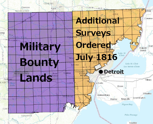
One of Lewis Cass' objectives as governor was to attract enough settlers to Michigan for the territory to achieve some degree of self sufficiency. His plan reached an obstacle when Congress decided that the two million acres surveyed in the winter of 1815-1816 were unworthy to be used as bounties promised to soldiers who would serve in the military for five years. This land was to be put up for sale, but its distance from any existing settlement and the disparaging report of the surveyors meant that it was unlikely to bring in homesteaders.
In a May 1816 letter to Josiah Meigs, Commissioner of the US General Land Office, Cass refuted the surveyors' negative reports:
the quality of the land in this Territory has been grossly misrepresented.... [The surveyors] came to this Country in the wettest season ever known, They run [sic] up the Western Boundary of the Military tract, which passes through the dividing Country between the waters running East and those running West, and they continued in the Country but a short time and saw but a Small part of it.Regardless of the quality of that land, Cass argued that the survey should be extended east toward Lake Saint Clair, Lake Erie, and the Detroit River, as this land was more likely to raise revenue and attract settlers. When deciding whether to follow Cass' recommendation, Meigs sought the opinion of James Abbott, a Michigan native and commissioner at the US Land Office in Detroit who knew the territory. Abbott agreed with Cass--the land closer to Michigan's eastern shores was far more likely to sell than the former military bounty tract. Convinced that the surveys should be extended, Meigs directed Edward Tiffin, Surveyor General of the Northwest Territory, to make the necessary arrangements in July 1816.
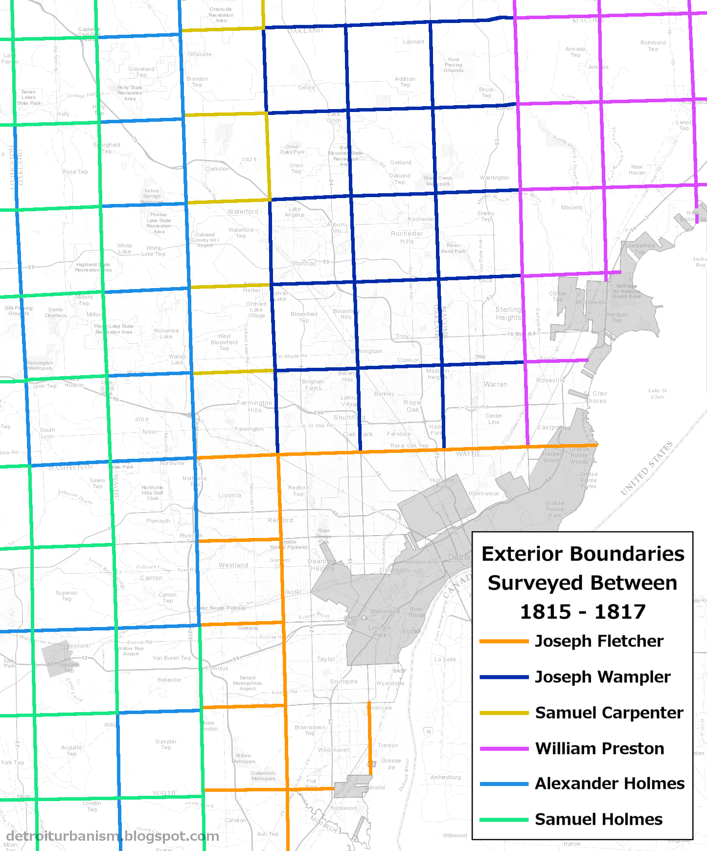
The first two sets of six-mile-by-six-mile townships surveyed in Michigan.
Joseph Fletcher returned to the field in the autumn of 1816 and set out on his first task in the new surveys: completing the east baseline to Lake Saint Clair. He began on September 23, 1816 at the eastern edge of the former military bounty lands, at the southwest corner of present-day Farmington Hills. Fletcher retraced Holmes' incomplete line and continued eastward, reaching the western shore of Lake Saint Clair on September 28.
Michigan's east baseline terminates at the eastern end of what is now a small subdivision on Fairlake Lane in Grosse Pointe Shores.

The baseline meets Lake Saint Clair behind this house at 11 Fairlake Lane.

Fletcher had been instructed to continue the baseline at the same bearing that Holmes had used. This created a problem. Throughout the previous winter, every surveyor set his equipment to a variation from magnetic north calculated back at Fort Defiance. But the farther each team traveled from that point, the less accurate that variation was. This could have been corrected by making periodic astronomical observations, but there was no time to spare and and no way to synchronize the multiple teams working in the field. As a result of maintaining the same magnetic variation over a broad area, Michigan's baseline gradually bent northward instead of following a perfect line of latitude as it was supposed to. By the time the baseline reached Lake Saint Clair, it deviated from its intended direction by two degrees.
Adding to his frustration, Fletcher realized that all survey lines near Detroit would have to be drawn at the same deviation. Otherwise, he reported to Tiffin,
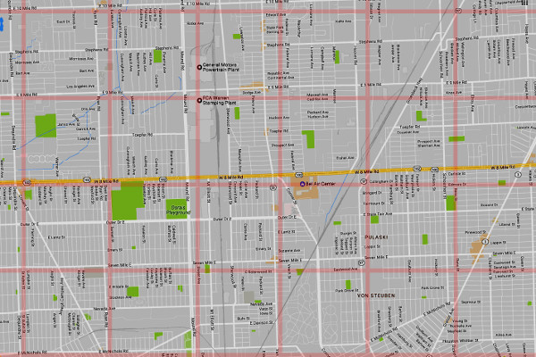
there would be a difference of 2° from the base line which would leave every town & Section at angular points—which would appear disagreeable on a general map—I communicated this subject to govern'r Cass—he agree'd with me in opinion, and earnestly requested me to run the lines agreeable to bearings of the base line.As a result of these compounding problems, the entire street grid in the Metro Detroit area is slightly askew.
An ideal grid vs. the present-day grid in Detroit and Warren.
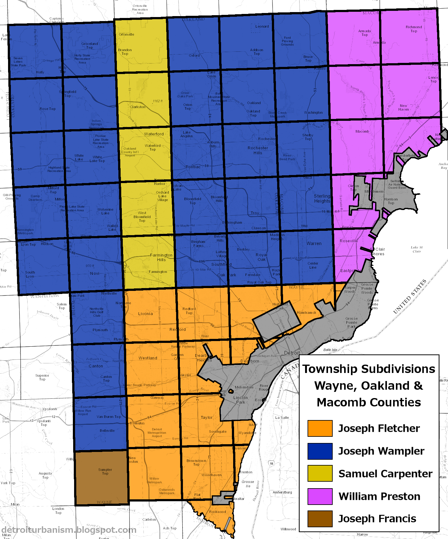
Fletcher worked throughout the remainder of 1816 and into 1817, surveying most of present-day Wayne County. William Preston arrived in late December 1816 to outline and subdivide all of the townships east of present-day Hayes Road and north of the Baseline. Joseph Wampler, who had subdivided townships in the military reserve in 1815, came in February 1817 and worked on the remainder of the new survey area (north of the baseline, west of Hayes Road). A full account of who surveyed the exterior boundaries and interior sections of every township in Wayne, Oakland and Macomb Counties is provided in the images below. Click each image for a larger version.
Other Anomalies
Errors were bound to crop up in an early 19th century survey of heavily timbered land. But even the limitations of the time are not enough to account for some of the aberrations seen in the grid today. Carelessness and defective equipment are the only explanations for some mistakes that permanently mark the landscape.
William Preston established the range line that later became Hayes Road in January 1817, and proceeded to survey the territory east of it. Joseph Wampler arrived the following month and began surveying his assigned area, starting with outlining the township that later became Warren and Center Line. When surveying the north border of this township from west to east, Wampler hit Preston's line 396.6 feet south of the township corner post set by Preston. Wampler did a few calculations and went back along his own line, moving his mile- and half-mile-posts so that they would form a straight line to Preston's corner. This line is now part of 14 Mile Road.
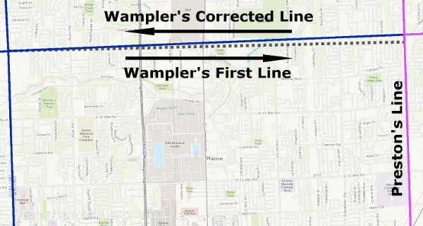
Wampler missed Preston's corner by 396.6 feet & adjusted his line accordingly.
"I then went on to Subdivide this township," Wampler reported, "and found in closing sections that I fell in still farther & farther South of (Preston's) corners." Wampler's lines on the eastern side of the township skew ever farther north in order to tie in to Preston's district.
As a result, the roads that developed along these lines bear witness to the disparities between Wampler's and Preston's surveys.
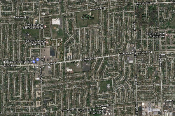
13 Mile Rd. between Schoenherr & Hayes in Warren.
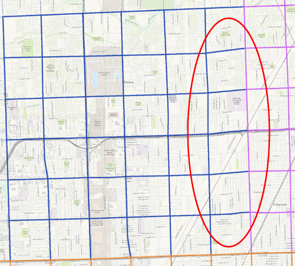
The most likely explanation for Preston's errors is that he was probably using a chain that was too long. "My chain is exactly standard length," Wampler wrote to Tiffin when reporting on this anomaly. Today we can verify that the errors were on Preston's side by examining his district using Google Earth. Measure the distance between any two roads that are supposed to be one mile apart, east of the Hayes Road line, in Macomb or Saint Clair Counties. Rather than being 5,280 feet apart, you will find that these distances run anywhere from 40 to 100 feet in excess than that. More than 500 square miles of southeast Michigan have been mismeasured because a surveyor named William Preston owned a defective surveyor's chain.
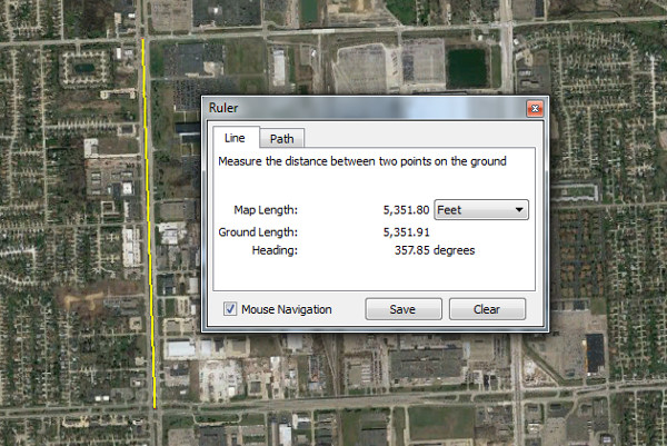
Preston's corners in Mound Road between 16 Mile Rd. &
17 Mile Rd. are 5,351.8 feet apart rather than 5,280.
First Land Sales
By the close of 1817, all of the townships east of the former military reserve were surveyed. On March 31, 1818, President James Monroe issued a proclamation scheduling the first land sales in the Michigan Territory. Parcels of 160 acres (one quarter of a square mile) within the three districts surveyed by Fletcher, Wampler and Preston were to be auctioned off during three separate periods: Fletcher's district (south of the baseline), July 6-19, 1818; Preston's district (north of the baseline, east of present-day Hayes Road), September 7-20; and Wampler's district (north of the baseline, west of Preston's district), November 2-15, 1818.
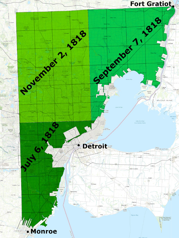
First dates of sales
In preparation for the sales, James McCloskey surveyed the Indian reservations in the three districts to ensure that they would be withheld. The area surrounding Fort Gratiot in present-day Port Huron was also reserved. Per US law, section number sixteen in each township was to be sold separately by the territory in order to fund public schools.
The sales were conducted by the US Land Office that operated out of the old Council House, located on the southwest corner of Jefferson Avenue and Randolph Street. Four days after the close of the first phase of sales, the Detroit Gazette reported,
Scarcely any persons from a distance attended the sales.... [T]he price of land vibrated from two to forty-one dollars [per acre]. The average price of all the land sold we understand was about four dollars. This land was purchased by actual residents of the country; men acquainted with its soil, situation, and prospects; who could not mistake in their estimate of its advantages, and whose opinions are shewn by the prices which they paid.Following the close of the second round of auctions, the Gazette lamented that
8210 acres only were sold, and the average price was a little over two dollars and fifty cents per acre. With some regret we have to state, that of the purchasers who appeared at the auction, the greater part seemed anxious only to select portions of land on which to found cities or villages, rejecting the fertile tracts which would be seized upon with avidity by the practical farmer.... There are yet remaining unsold, between three and four thousand tracts of land, of 160 acres each.Despite these disappointing returns, the government continued to acquire and survey Native American land. The auctions were later done away with, and quarter sections could be freely selected and purchased at a fixed price. Settlers began to pour in from the eastern states upon the completion of the Erie Canal in 1825, and land sales escalated to a fever pitch until the beginning of an economic recession in 1837. Surveys of public land in Michigan continued until the 1850s.
The System Today
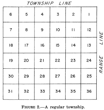
When land is divided according to the US Public Land Survey System, a mechanism is set in place by which every parcel is unambiguously defined, legally delineated, and sold to a private owner efficiently and reliably. This system is still used to define parcels of land to this day. Every township in Michigan is identified by its distance east or west of the meridian and north or south of the baseline. For example, Shelby Township is three townships north of the baseline and twelve townships east of the meridian--therefore, it is designated "Township 3 North, Range 12 East." Furthermore, each township is divided into thirty-six sections and numbered according to the following scheme:
Therefore, the square mile bounded by 22 Mile, 23 Mile, Mound, and Van Dyke Roads in Shelby Township is legally defined as "Township 3 North, Range 12 East, Section 21." You can break this down farther and define parcels as "the northwest quarter" of a particular section, or "the east half of the southwest quarter," or "the north half of the east half of the northwest quarter," etc. These terms are legally binding within the system. The land on which my own house stands is legally defined as: "the south 165 feet of the north 1,320 feet of the west 20 acres of the southwest quarter of Township 1 North, Range 9 East, Section 23."
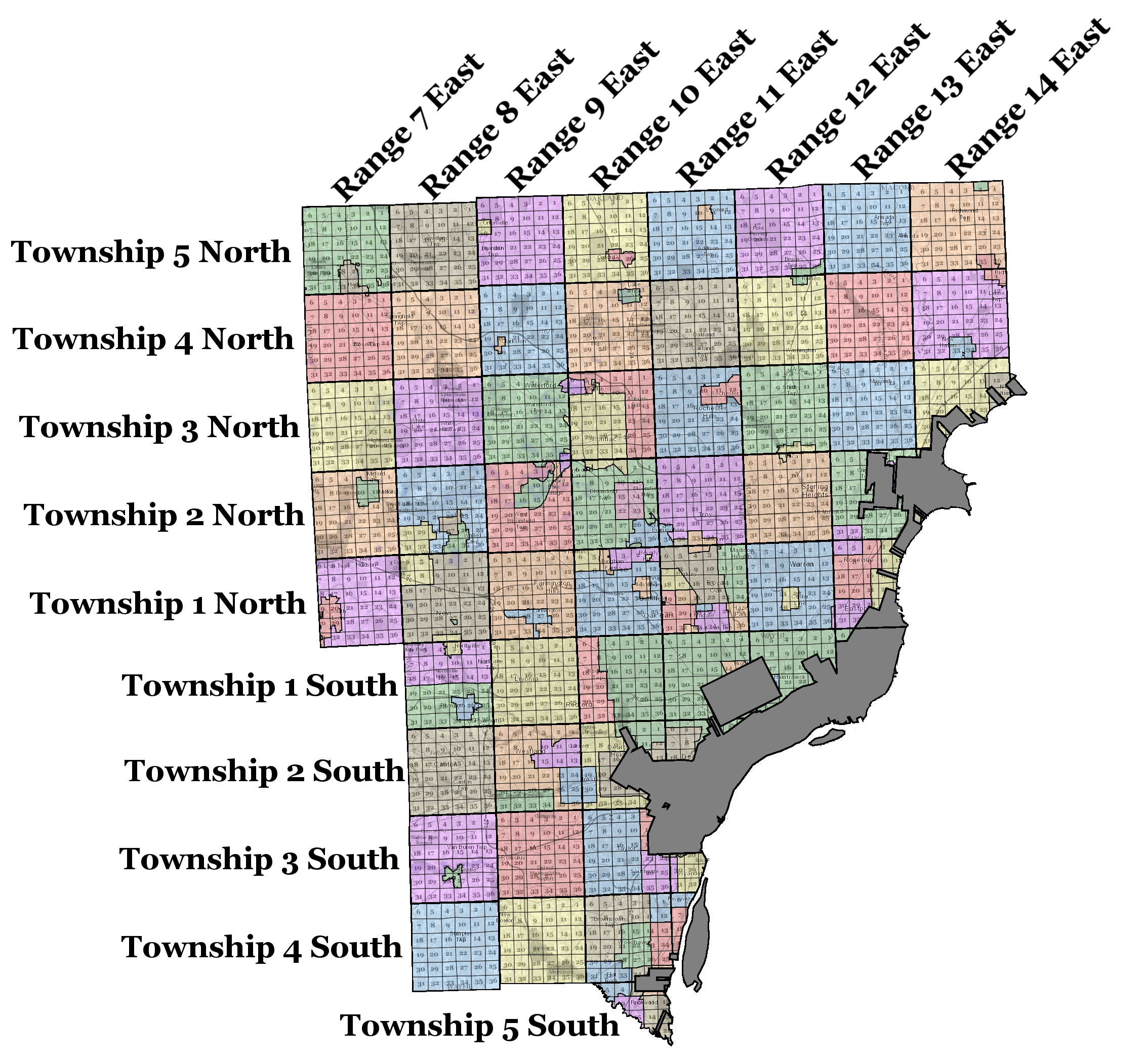
Below is an image showing the township, range and section number of every piece of land in Wayne, Oakland, and Macomb Counties that is subject to the US Public Land Survey System. The grayed-out areas were not federal property at the time of the original surveys. Click on the link below the image for a full-sized version.

Click here for a larger version of this image.
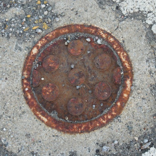
The original surveyors set cedar posts in the ground every half mile in their paths, and each post displayed markings that indicated the bordering township, range, and section numbers. Over the last two centuries, the posts have been replaced by more substantial markers. In Metro Detroit today, these points are marked by steel rebar driven into the earth and topped with brass or aluminum caps. They are accessible to modern surveyors inside of protective cast iron covers called monument boxes. These can be spotted in the intersections of major roads that follow the original survey lines.
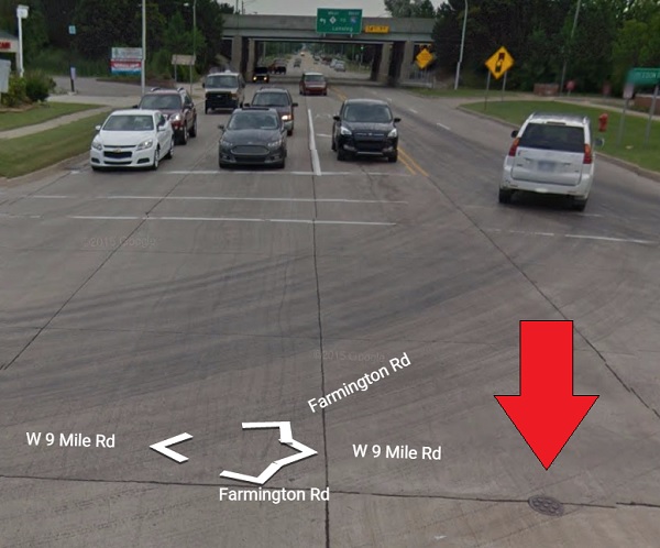
The photo above shows the spot where surveyor Samuel Carpenter set a post on May 11, 1817 to mark the corner where sections 27, 28, 33 and 34 in town 1 north range 9 east meet. Today it is the center of the intersection of Nine Mile and Farmington Roads. The most recent marker to be placed here was a two-foot length of 5/8" rebar topped with a brass cap. It was set in April of 1997 by John N. Redash P.S., replacing an iron bar that had previously served as the section corner.
We pass by these markers every day, unaware that we are traveling along a network established two centuries ago. This system is practically hidden plain sight, yet it defines more than 99% of all private property and municipal boundaries in Michigan. When one's eyes are opened to the system, Michigan's 58,000 square miles of land no longer feel like a bewildering disarray of farms, cities and wilderness--every square mile of this state's interior was delineated and identified according to township, range, and section number long ago. You can no longer be "nowhere."
Portals Through Time
To behold the checkerboard pattern of tens of thousands of square-mile survey sections running in every direction from an airplane or in satellite photos gives one a vague sense of disquieting awe. There is something to admire in the defiance of carving the naked wilderness into an unyielding grid, or the hubris of drawing rectangular townships on a spherical planet. This was the system designed to realize Thomas Jefferson's dream of a nation of yeoman farmers, and it was also the means by which the land of the First Nations was colonized and subjugated.
What we think of as an old-fashioned, idyllic farm scene--the red barns, the crops of wheat, the herds of cows and sheep--is every bit alien to this land as the red Martian weeds choking the English countryside in H. G. Wells' War of the Worlds. And the age of suburban sprawl has rendered the landscape even more unrecognizable still.
Yet there remain windows into the past by which we can explore the country in its pre-colonized state: the surveyors' township plats. Each one is a snapshot in time of the nexus of our collective history--that instant when the land fell under the domination of Anglo-Saxons after millennia of indigenous possession.
(present-day Waterford).
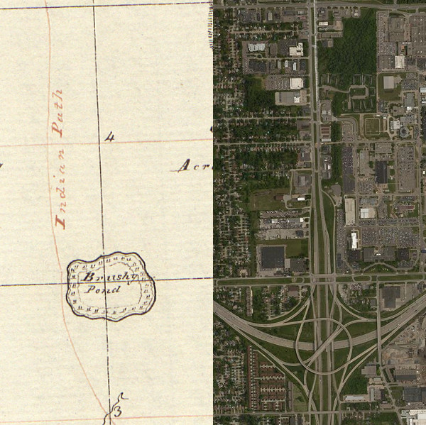
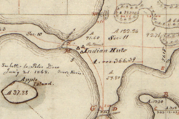
After a particular township was subdivided into its thirty-six sections, the surveyor would use his field notes to prepare a map of the tract, showing the locations of lakes, rivers, creeks, swamps, prairies, and springs. The field notes also contained information on the topography, soil, and vegetation. Some plats also show the locations of dwellings and Indian trails--the fading remnants of the old civilization as it was pushed westward.
near the present-day intersection of Mound Rd. and I-696 in Warren.
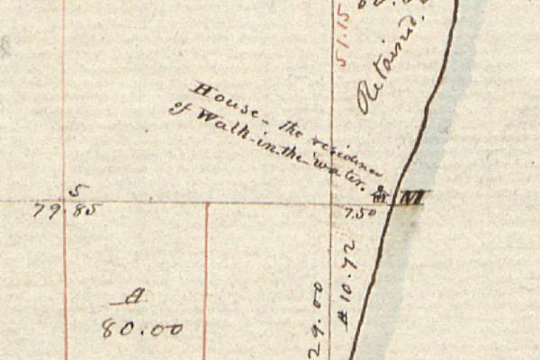
The plat below marks the location of the cabin of the famous Wyandotte chief, Walk-in-the-Water. The section line run by surveyor Joseph Fletcher happened to intersect this home, according to his field notes. This was once part of the Wyandotte village of Maguaga, which at the time of the survey was soon to be relocated to Huron Township. Today, this spot is where Eureka Road meets the Detroit River.
(present-day Wyandotte).
Below is a plat by Samuel Carpenter showing trails and huts near the shore of Orchard Lake in present-day West Bloomfield.
(present-day West Bloomfield).
The surveyors were eyewitnesses to what was soon to be a lost world, and the documents they left behind conjure that forgotten landscape with a level of detail that allows us to pinpoint exactly where natural features previously existed. Where there was once a creek fed by a freshwater spring, for example, there may now be an eleven-lane expressway. Where the surveyor's plat shows a meadow might today be a subdivision of some of those fine homes constructed by PulteGroup Incorporated. And where there used to stand a forest of red oak, beech, and maple may now be a CVS Pharmacy, a Cheesecake Factory, and an International House of Pancakes. What other wondrous transformations might this land see in another 200 years?
Where can one access the original plats to learn about our local areas?
ReplyDeleteIf you know the township and range number, you should be able to produce and download PDFs of the original plats here: https://glorecords.blm.gov/search/default.aspx?searchTabIndex=0&searchByTypeIndex=1
DeleteAlternatively, they can be found on Seeking Michigan: http://seekingmichigan.org/discover/surveyor-plat-maps
DeleteThanks for taking the time to write this recap! As someone who moved to Michigan recently, I appreciate it. I had been wondering how the grid system was set up, why 8 Mile was sometimes called "Baseline" and how the Detroit metro area came to be how it is today. Your account is as clear as it is thorough.
ReplyDeleteThis comment has been removed by the author.
ReplyDeleteI'm Абрам Александр a businessman who was able to revive his dying lumbering business through the help of a God sent lender known as Benjamin Lee the Loan Consultant of Le_Meridian Funding Service. Am resident at Yekaterinburg Екатеринбург. Well are you trying to start a business, settle your debt, expand your existing one, need money to purchase supplies. Have you been having problem trying to secure a Good Credit Facility, I want you to know that Le_Meridian Funding Service. Is the right place for you to resolve all your financial problem because am a living testimony and i can't just keep this to myself when others are looking for a way to be financially lifted.. I want you all to contact this God sent lender using the details as stated in other to be a partaker of this great opportunity Email: lfdsloans@lemeridianfds.com OR WhatsApp/Text +1-989-394-3740.
ReplyDeleteThis comment has been removed by the author.
ReplyDelete