
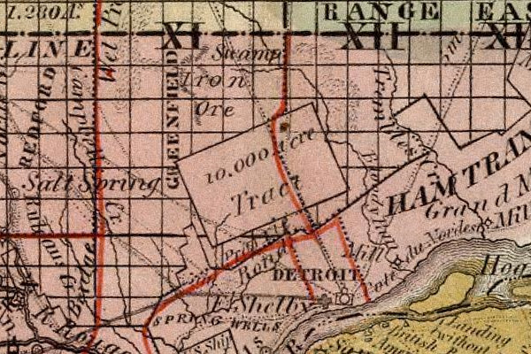
The Ten Thousand Acre Tract is in a way a continuation of the Park Lots. The two combined areas contained the public lands donated to the Michigan Territory by the federal government in order to fund the construction of a courthouse and a jail in Detroit. The title "Ten Thousand Acre Tract" is actually a misnomer, as it was intended to make up the balance of the 10,000 acres after the survey of the Park Lots was completed.
The basic shape and position of the Ten Thousand Acre Tract had been determined at least as early as 1810, when surveyor Aaron Greely completed his Map of Private Claims on Lake St. Clair, the Detroit River and Lake Erie. Greely depicted the full donation tract as one contiguous whole with the Park Lots. It does not appear that the tract was actually surveyed by Greeley, only that he intended to show a suitable location where 10,000 acres could be platted as close as possible to the city without interfering with private property.
Multiple setbacks delayed any parceling out of the tract. Most significantly, the territorial government's land records, including its copy of the Greely map, were confiscated or destroyed when the British occupied Detroit during the War of 1812. Without these documents, the local government was unable to proceed with a survey.
On November 7, 1815, Governor Lewis Cass with Judges Augustus Woodward, John Griffin and James Witherell wrote to Josiah Meigs, Commissioner of the US General Land Office, requesting that a surveyor be sent to Detroit to determine the location of the donation tract. In a letter dated December 26, 1815, Meigs instructed the Surveyor General of the Northwest Territory, Edward Tiffin, to send a deputy surveyor to Detroit for this task. Tiffin wrote to Cass on January 3, 1816 to assure him that help was on its way. His letter included a copy of part of the Greely map, showing the intended boundaries of the donation tract.
The surveyor chosen for the job was Joseph Fletcher, a resident of Gallipolis, Ohio, who also served as a judge there. He arrived in Detroit in February 1816 in order to assist with the survey of other public lands in the Michigan Territory--a duty he attended to before turning to the matter of the donation tract. Fletcher signed a contract with the Commissioners on Land Titles (appointed by the Governor and Judges) on May 1, 1816 to "survey, subdivide, measure, and mark a certain tract of ten thousand acres," for which he was to be paid $2.50 per mile. (A card catalog listing in the Burton Historical Collection claims that this document is located in the John R. Williams papers, but it could not be located while researching this article.)
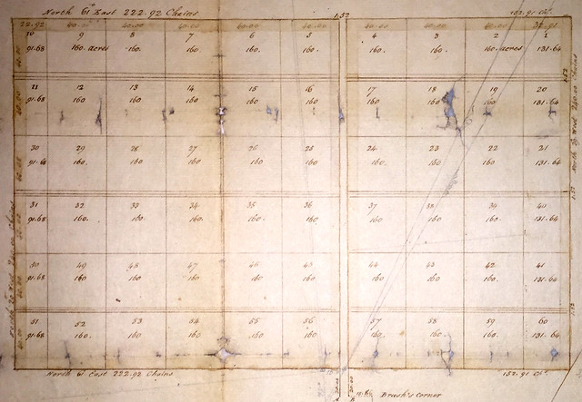
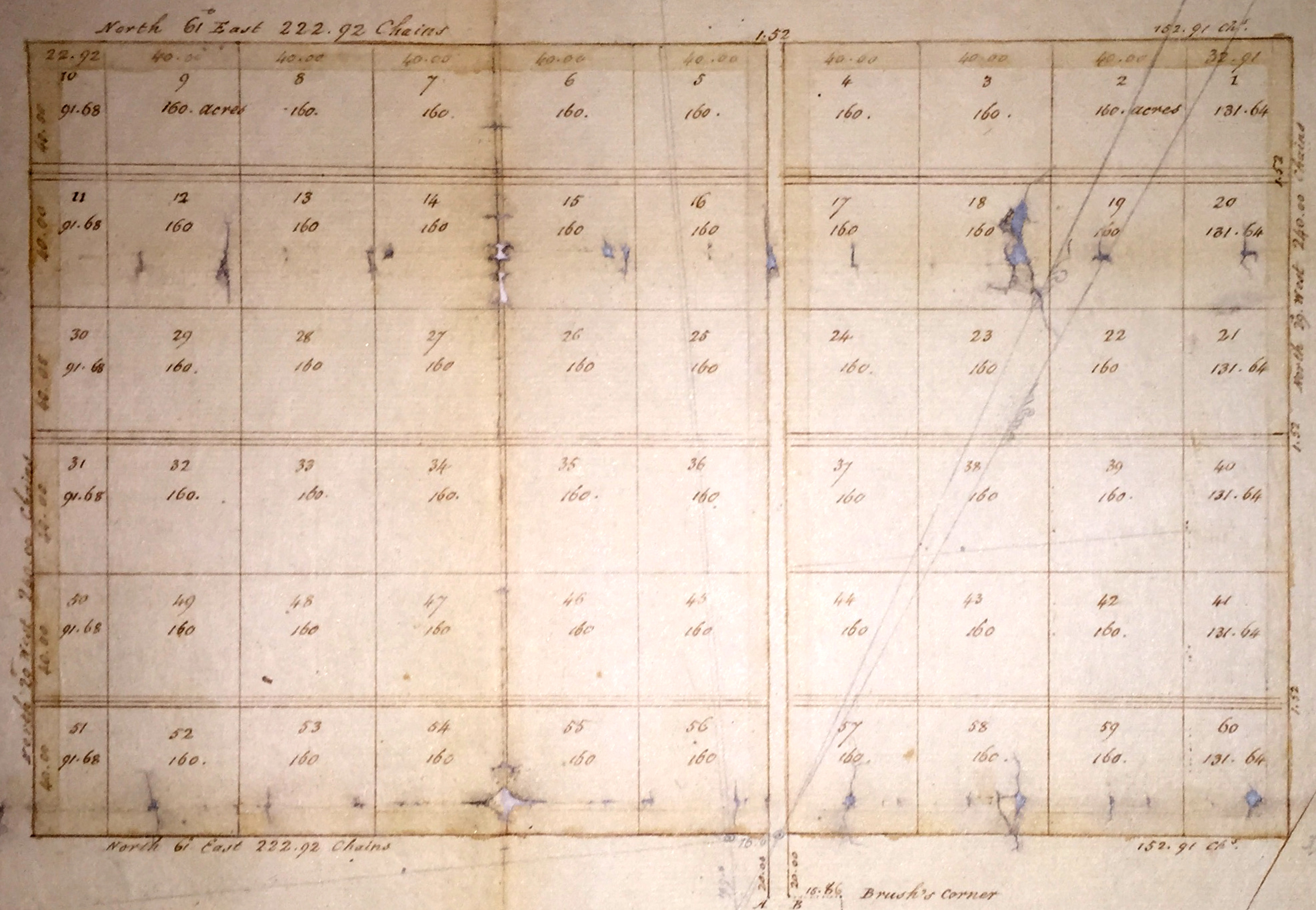
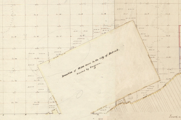
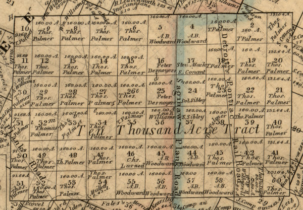
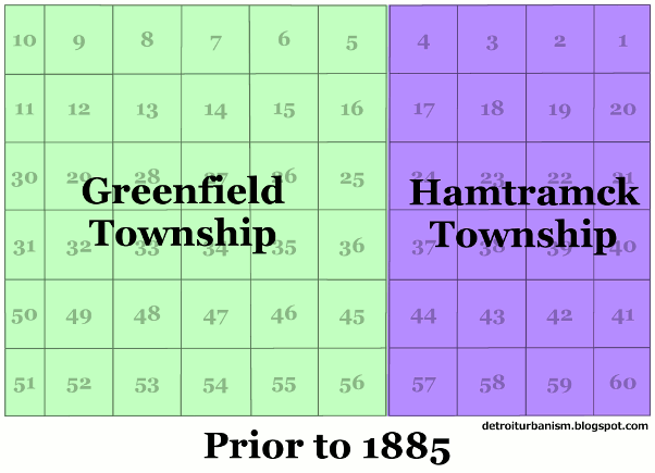
Fletcher did not connect the Ten Thousand Acre Tract to the Park Lots as depicted on Greeley's map, but instead left a quarter-mile gap between the two. His plat bears measurements identical to those indicated by Greeley: 4.72 miles wide by three miles tall, totaling 9,056.4 acres. He divided the tract into sixty so-called "quarter sections." Each contained 160 acres (one quarter of a square mile), except for sections along the western and eastern edges, which contained 91.68 and 131.64 acres each, respectively.
Click here for a larger version of this image.
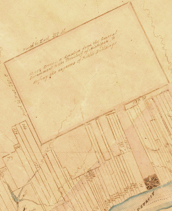
The plat contains the following caption:
Pursuant to an order, and instructions, from His Excellency Lewis Cass Esq. Governor of Michigan Territory, I have surveyed, admeasured [portioned], and laid out the above described tract of Land, containing 9056.40 acres, aback, and adjoining the private claims near Detroit do certify that it hath such marks both natural & artificial as are specified in the field notes returned with this Plat.Fletcher's survey leaves a 100-foot-wide space for the continuation of Woodward Avenue that does not detract from the acreage of any section. The commissioners who oversaw the survey and distribution of the donation tract ruled that the rights-of-way should also be reserved for streets "100 feet wide to run from East to West thro the centre of each tier of Sections," but these rights-of-way were to detract from the parcels through which they ran. The future locations of these roads are also indicated on Fletcher's plat.
Detroit June 2nd 1816.
(signed) Joseph Fletcher, D[eputy] Sur[veyor]
Unexplained Miscalculations
For reasons that are unclear, the measurements and bearings on Fletcher's plat are completely incorrect. The plat is, after all, a little "too" perfect. To survey a rectangle of this size and divide it into sections that conform to the plan down to the last decimal point technically isn't even possible due to the curvature of the Earth!
The actual dimensions of each quarter section are approximately 1% greater than indicated by Fletcher. What could account for this? Surveyors at the time measured land with sixty-six-foot-long Gunter's chains, which were well known to expand due to stretching, temperature alterations, and even wear in the links. But it seems incredible that Fletcher's chain could have expanded a full eight inches. Errors of this magnitude are not seen on Fletcher's other Wayne County surveys performed around the same time. However, it's worth noting that part of Fletcher's work on the Michigan Baseline at a later date was rejected for gross inaccuracies.
The mismeasurement of the Ten Thousand Acre Tract is recalled by Friend Palmer in his book, Early Days in Detroit, published around 1906. "It was found in re-surveying [the tract] into parcels," explained Palmer, that "many of the quarter sections over-ran." He explained,
In some instances there would be quite a strip of land running clear across a quarter section (after the purchasers had got all the land their deeds called for), that no one appeared to own, so they divided it up among themselves. For instance, two parties purchasing a quarter section would have the surveyor divide it equally, eighty acres to each. When the survey was completed it appeared that there was a strip of land from sixteen to twenty feet wide between the two eighties that there was, apparently, no owner or claimant for, so the parties gobbled the sixteen or twenty feet and set their fences accordingly.There is another error in Fletcher's plat. He indicates a bearing of N 29° W for the vertical boundaries, just as in Greely's map. The actual lines, however, were run at N 26° W. This was presumably done to bring the survey into alignment with the Park Lots. This prevented creating a bend in Woodward Avenue between the two areas. It's not understood why Fletcher didn't simply write down the correct angles in his plat. He did, however, indicate the true bearings when surveying the public land immediately surrounding the tract the following year.
Sale & Protest
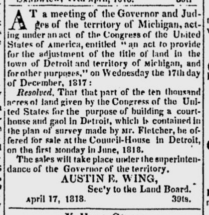
On December 17, 1817, the Governor and Judges of the Michigan Territory voted to sell the Ten Thousand Acre Tract in quarter sections according to Fletcher's survey. They set a minimum price of two dollars per acre, and chose June 1, 1818 as the date of the sale, to be held at the Council House.
Notably absent from that meeting was Judge Woodward, a staunch opponent of the sale who composed a long and detailed argument against it. The meeting where the Governor and Judges voted to sell the land, Woodward pointed out, "was not on the day appointed by law, but on a different day, without adequate or regular notice, and therefore intriguing, violating public laws, iniquitous, and corrupt." Woodward reminded his colleagues that they were bound to obey the Plan of Detroit, which was at odds with the lines and angles of Fletcher's survey. Woodward argued that Detroit was destined "to be a great interior emporium, equal, if not superior, to any other on the surface of the terraqueous globe," and that parceling out farmland in arbitrary rectangles to satisfy a handful of land speculators at the expense of facilitating the growth of a great future metropolis was criminally negligent. Woodward's protest, needless to say, was to no avail.
Despite the controversy, the sale hardly generated any interest. The Land Board was forced to hold a second auction the following week.
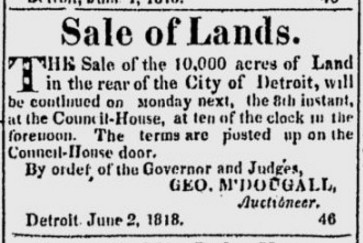
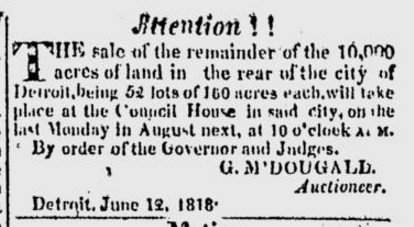
With only eight of the sixty lots sold by the end of the second auction, a third was advertised for August 26, 1818.
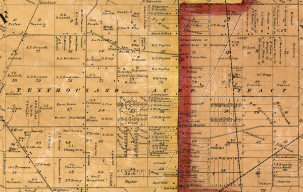
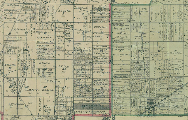
The sales simply failed to attract interest. Ironically, Judge Woodward purchased eight quarter sections, more than any other buyer. But without enough hard currency to build the long-delayed courthouse and jail, the territorial government had to use the remaining land itself as payment. Most of the quarter sections were deeded to Thomas Palmer, one of the contractors. Below is a detail from an 1855 map of Wayne County by John Farmer, indicating the names of the original owners of each quarter section.
The Courthouse & Jail
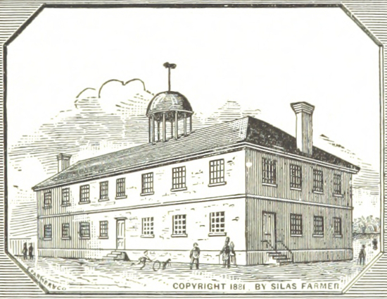
And what became of the buildings whose construction was the entire point of this ordeal? The jail was built by contractors Stephen Mack and Shubael Conant, having been completed in May 1819. It stood in the center of Section 7 on the Woodward Plan, where the Skillman Branch of the Detroit Public Library is today. The jail was torn down in 1848 after a site for a new jail was chosen.
_Detroit,_p267_OLD_JAIL,_ON_THE_SITE_NOW_OCCUPIED_BY_PUBLIC_LIBRARY.jpg)
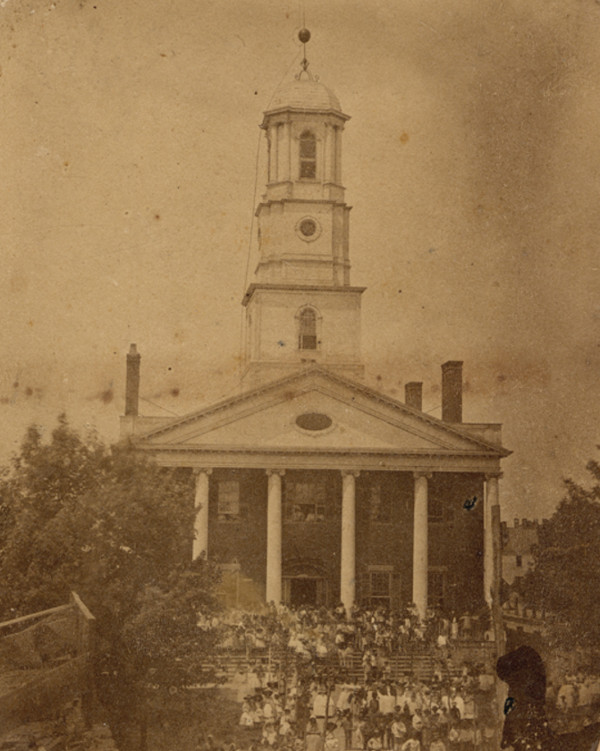
The courthouse, used as the Territorial and later the State Capitol Building, was constructed by Thomas Palmer and David McKinstry between 1823 and 1828 in the center of Section 8 on the Woodward Plan, where Capitol Park is now. The building was repurposed after Lansing became the state capital in 1847. It was eventually used as a high school, and a four-story addition was built in front of the former courthouse in 1875. Both structures burned in 1893.
Woodwardville
Judge Woodward knew that his Plan of Detroit would never expand into the Park Lots and Ten Thousand Acre Tract because of the way these areas were surveyed. But having obtained eight quarter sections of the Ten Thousand Acre Tract, he couldn't resist performing the role of city planner once more.
Six of Woodward's quarter sections--44, 45, 55, 56, 57 and 58, all lying in what is now the New Center area--were divided into thirds. These were presumably farms, despite Woodward's earlier insistence that this land be subdivided into city blocks. The two remaining quarter sections--numbers 4 and 5--contained the most interesting part of Woodward's new plan. The east half of quarter section 5 and the west half of quarter section 4 were platted into a new village: Woodwardville.
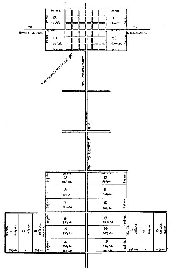
Centered around Woodward Avenue north of what is now the Davison Freeway, the village was laid out in somewhat conventional rectangular blocks. The grand triangles and hexagons of the Plan of Detroit would not work on such a modest scale. The plan did contain some interesting touches, such as a 450-foot-wide central square and blocks with unique alley configurations.
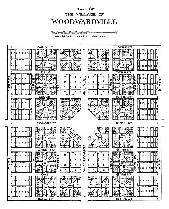
The village never came into being. A traveler who walked the Saginaw Trail from Detroit to the Saginaw River in 1822 noted,
Six miles from Detroit is the site of what is ironically called "Judge Woodward's City." This gentleman has been attempting, the season past to induce emigrants, on certain conditions, to cut the timber from his land with a view to its settlement. We passed one or two miserable cabins, the only edifaces as yet created to show that human industry has done aught towards the accomplishment of the judge's project.Woodward's plat was never recorded as a legal subdivision, and it's not clear if any lots were actually sold. He left the territory in 1825 and died two years later. According to Clarence M. Burton, the executors of Woodward's estate sold the judge's holdings in the Ten Thousand Acre Tract to Thomas E. Davis for $7,455.
From Rural Suburb to the Heart of the City
Some remnants of the Ten Thousand Acre Tract's rural past survive, but they are not easy to find. One example that remains well-hidden among modern brick homes is the James Smith farmhouse, at 2015 Clements Street.
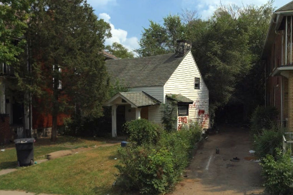
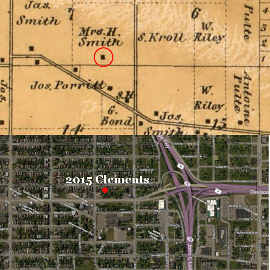
Concealed under a veneer of vinyl siding is a log house, the second-oldest structure in the city. It is believed to have been built between 1820-1850 in its present location in quarter section 7. The surrounding area was platted as Robert Oakman's Twelfth Street Subdivision in 1916, with streets and lot lines running at odds with the orientation of the log house. The house's location is indicated on an 1860 atlas of Wayne County, shown below.
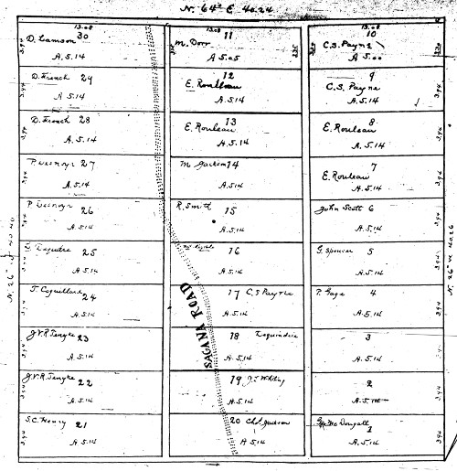
Over the years, the farms of the Ten Thousand Acre Tract were divided into smaller and smaller plots, many as small as five acres. Below is a plat, made in 1822 by surveyor John Mullett, showing the subdivision of quarter section 46 into thirty small farms. This plat is of special interest because the original location of the "Sagana Road" Indian trail is shown. Quarter section 46 today is approximately bounded by Rosa Parks Blvd, the John C. Lodge Expressway, Virginia Park St., and Clairmount St.
The first subdivision of city-sized lots to appear on the Ten Thousand Acre Tract was made on land owned by William and Susan Livingstone, straddling the border between quarter sections 58 and 59. Their plat was recorded in June 1872.
Click here for a larger version.
Beginning in 1885, the tract became the battle ground in the annexation conflicts between Detroit, Highland Park, and Hamtramck, with Detroit being the first to incorporate part of the area. After Highland Park and Hamtramck were established as villages, Detroit managed to consume parts of them in addition to the surrounding townships. Although the Home Rule City Act of 1909 helped prevent the villages from losing additional territory, Detroit did ultimately surround both of them geographically. The smaller municipalities ultimately incorporated as cities. Below is an animated GIF outlining the history of municipal corporations within the Ten Thousand Acre Tract.
Subdivisions within the tract evolved in a much more orderly fashion than those among the ribbon farms and Park Lots. The north-south lines dividing the quarter sections became major streets: Conant, Joseph Campau, Dequindre, Oakland, Hamilton, Twelfth (Rosa Parks Blvd.), Linwood, Dexter, and of course Woodward Avenue. The south border of the tract became Grand Boulevard. Subdivisions tended to be laid out so that east-west division lines tended to fall on alleys.
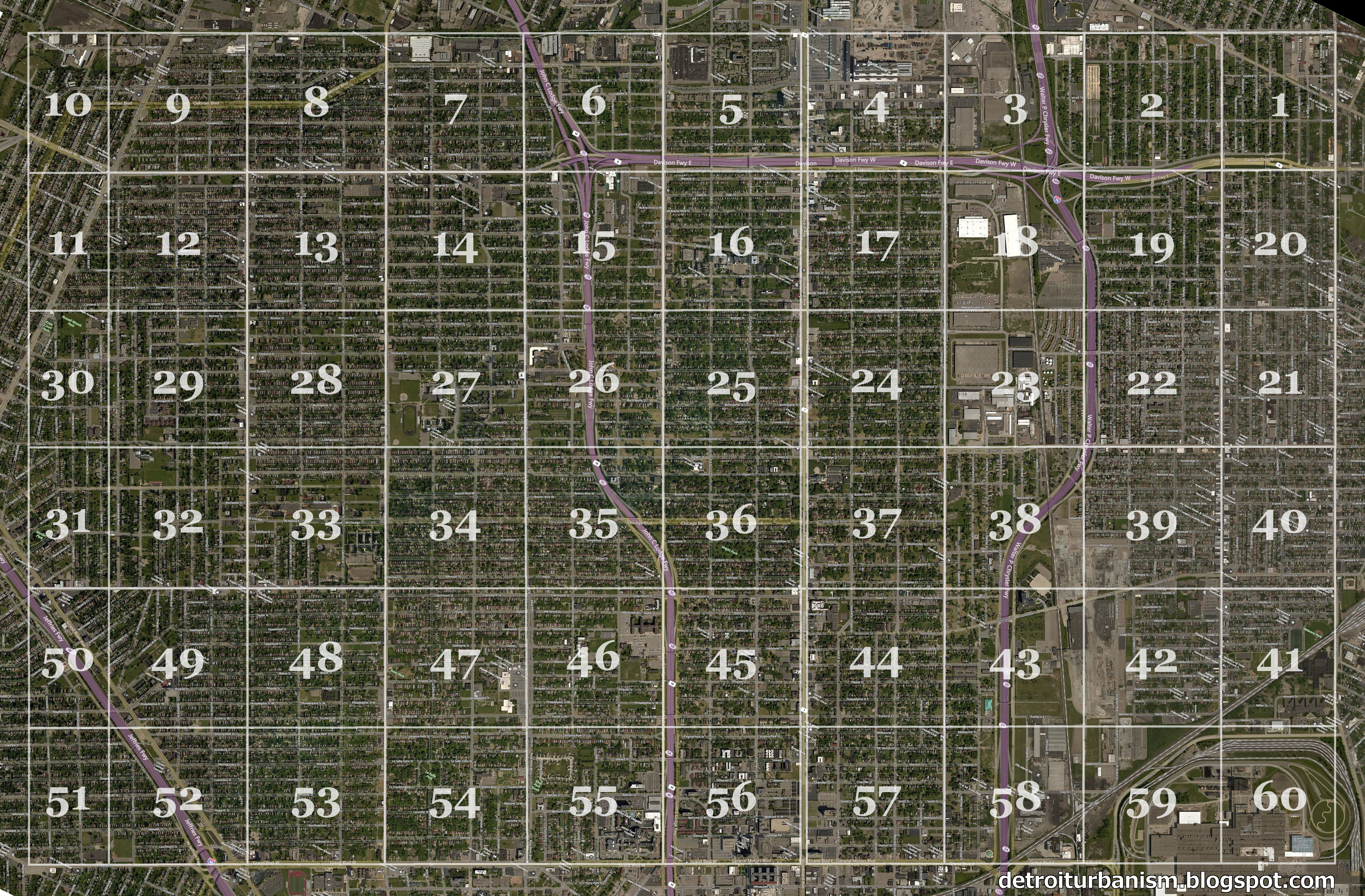
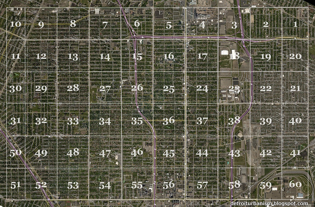
Two centuries ago, a surveyor with a few assistants and a (probably defective) surveyor's chain traced imaginary lines in the meadows, swamps and forests north of Detroit. The stakes driven into the earth over those few days dictated the boundaries of farms and pastures which in turn shaped the physical development of the three cities at the core of the metropolitan region. The effect of the survey is obvious when the lines and quarter section numbers are superimposed over a modern satellite image of the Ten Thousand Acre Tract. Click here for a full-resolution version of this image to see the influence of the original plat in detail.
Click here for a larger version.
This is very interesting to me, especially since I used to live near this area. Your research and writing is excellent. Thanks for writing.
ReplyDeleteTruly great work Paul! A lot of excellent information about a not often discussed, but extremely important, part of our local history. Of course the main, and most obvious, remnant of the the Tract is the angled street pattern that runs through the central part of the city (and HP & Hamtramck) up to just north of Davison. Every time any discussion of Detroit's unusual street pattern comes up I always point people to that first map you posted, which shows the ribbon farms and the Ten-Thousand Acre Tract on the river-based orientation, surrounded by the Northwest Ordinance survey lines oriented on cardinal directions.
ReplyDeleteOne thing that I do find a little confusing though is the location of the stillborn "Woodwardville". You first talk about the subdivision of Woodward's holdings in what's now the New Center area, but then talk about Woodwardville being on Woodward north of Davison. I believe that the first map you posted under the Woodwardville heading may addresses this confusion somewhat. If I read it correctly, Woodward had holdings at the southern end of the Ten-Thousand Acre Tract that he subdivided into farm lots, but also held a smaller section several miles away at the northern end of the Tract, which is where the planned village was supposed to rise.
Sorry for the confusion about Woodwardville, but what you said at the end was exactly right--Woodward's quarter sections lower down in the tract were farm lots in today's New Center area, and the actual village of Woodwardville was up in today's Highland Park.
DeleteThe next major post I'm working on will be about the Northwest Ordinance survey lines, so stay tuned. :)
Excellent and fascinating article, thanks. One curiosity is in the 1876 map's quarter section 40, the line separating lots 30 and 31 is skewed compared to all the other lots in that row. This is still evident today in the slightly diagonal alley that is bounded by Gallagher, Charest, Evaline, and Holbrook in Hamtramck. I started a thread about it on DetroitYes: https://www.detroityes.com/mb/showthread.php?21309-Diagon-alley-in-Hamtramck
ReplyDeleteThanks! I replied on the DetroitYes thread, but the earliest cause I can tell is DeWitt C. Holbrook's 1869 subdivision of quarter section 40 was the first time this line was legally established. Maybe the first time a fence was set up here it was done without a surveyor, but they decided to leave the division line as it was (??). This is that first subdivision: https://c1.staticflickr.com/5/4232/35282796706_613aa60b71_b.jpg
DeleteI'm Абрам Александр a businessman who was able to revive his dying lumbering business through the help of a God sent lender known as Benjamin Lee the Loan Consultant of Le_Meridian Funding Service. Am resident at Yekaterinburg Екатеринбург. Well are you trying to start a business, settle your debt, expand your existing one, need money to purchase supplies. Have you been having problem trying to secure a Good Credit Facility, I want you to know that Le_Meridian Funding Service. Is the right place for you to resolve all your financial problem because am a living testimony and i can't just keep this to myself when others are looking for a way to be financially lifted.. I want you all to contact this God sent lender using the details as stated in other to be a partaker of this great opportunity Email: lfdsloans@lemeridianfds.com OR WhatsApp/Text +1-989-394-3740.
ReplyDeleteAll thanks to Elegant loan firm for helping me secure a loan of $1,000,000.00 USD to establish my Foodstuff supermarket business in different places. I have been looking for financial help for the past four years. But now, I am completely stressed free with all the help of the loan officer Mr Russ Harry. So, I will advise any person who seeks funds to improve his or her business to contact this great firm for help, and it is real and tested. You can reach him through- Email --Elegantloanfirm@Hotmail.com- or Whats-app +393511617486.
ReplyDelete