

We are living in a 200-year-old matrix marked by brass and iron. It is such an integral part of our daily lives that we barely even notice it. This complex system hides in plain sight--in fact, it is visible from outer space.

It's no accident that Metro Detroit--a region historically apathetic to organized urban planning--ended up with a neat grid of roads set one mile apart. But there is a deeper order and complexity to the system beyond a convenient grid. Its origins lie deep in the early history of the United States, and is one of the boldest utopian social engineering experiments ever proposed by its founders.
The US Public Land Survey System
When the United States gained independence in 1783, the new republic was in debt, and the Continental Congress did not have the power to impose taxes. The federal government's only source of capital was the millions of acres of Native American land west of the Appalachian Mountains that Britain no longer protected. The Continental Congress appointed a committee, chaired by Thomas Jefferson, to devise an efficient system for dividing and selling this land, as well as outlining the process by which new states could be carved out of the territory. This committee's recommendations became, after a few alterations, the Land Ordinance of 1785--the foundation of the US Public Land Survey System.
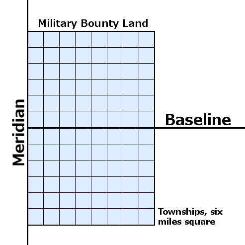
The system would work like this: Once a treaty extinguished Native American ownership of a given area, the land was to be surveyed. A surveyor would begin by establishing a "Point of Beginning" or "Initial Point" in a more or less arbitrary location in a new territory. From there, a Meridian (running north-south) and a Baseline (running east-west) would be drawn, becoming the axes along which square townships were to be established. Jefferson believed that these surveys should follow a new system of measurement using "geographical miles" (one second of one degree of the Earth's circumference, or 6,086.4 feet), and laying out townships measuring ten geographical miles on a side. But the final version of the Land Ordinance codified townships measuring only six miles on a side, and that conventional measurements would be used. Finally, each township was subdivided into thirty-six "sections" measuring one square mile each.
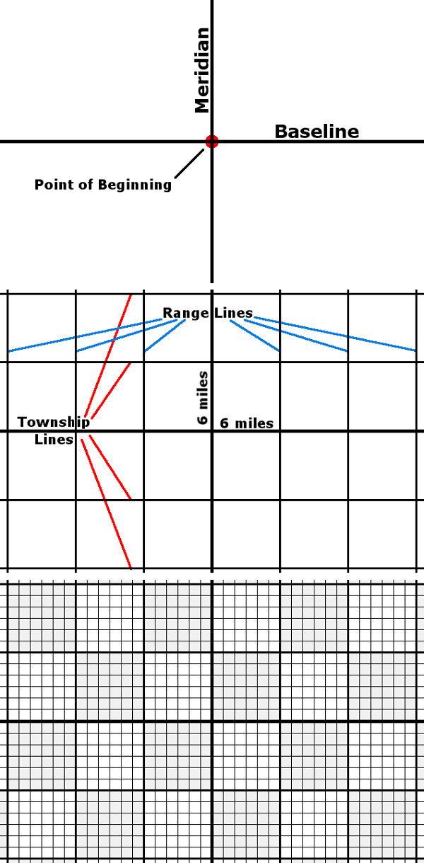
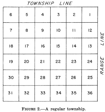
Beginning in 1796, the following scheme was adopted to number each square-mile section within every new township:
These townships covered large swaths of Ohio, Indiana, Illinois, Alabama, Mississippi, and Louisiana according to various baselines and meridians before finally coming to Michigan.
The Treaty of Detroit
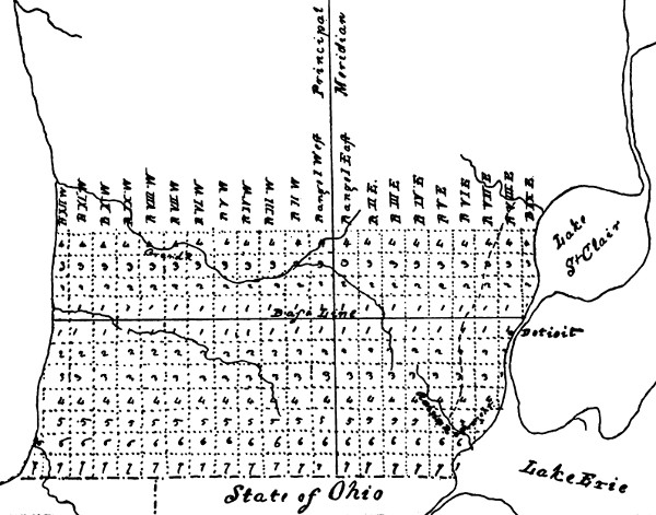
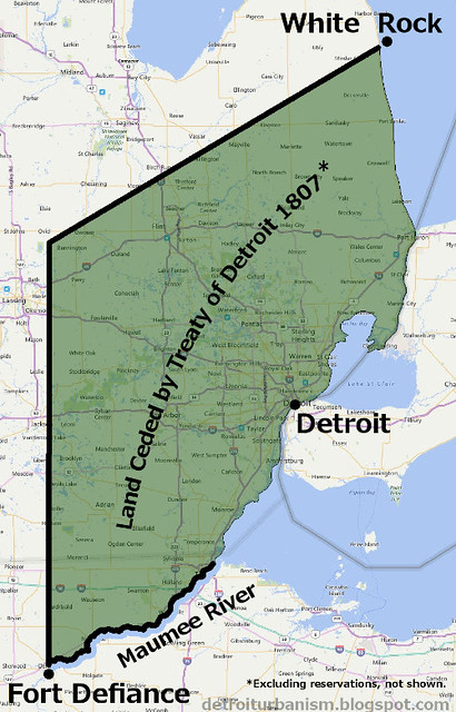
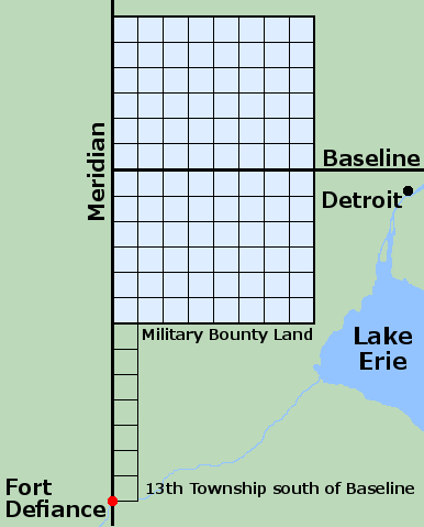
The 1795 Treaty of Greenville excluded all Native American ownership of land within six miles of the Detroit River. Even before the First Nations were pushed farther west, the US government began to contemplate a survey of Michigan, knowing that more treaties were inevitable. Jared Mansfield, Surveyor General of the Northwest Territory from 1803-1812, drew the sketch pictured below, showing how Michigan's baseline and meridian should be situated. It was included with a letter to Albert Gallatin, written in May of 1807, in which he suggested that the territory's baseline be run "a little North of Detroit."
The Treaty of Detroit was signed several months later, ceding most of southeast Michigan to the US government, aside from a few designated Indian reservations. Native Americans were permitted to hunt and trap on this land until it was sold to private owners.
Before this tract could be surveyed, the government first had to settle all claims of private property within it. Most of these private claims were the "ribbon farms," surveyed by Aaron Greeley between 1808-1810. Another postponement of the public land survey resulted from the War of 1812 and its aftermath. Work would not begin on the public survey until eight years after the signing of the Treaty of Detroit.
The Military Bounty Land
In late 1811 and early 1812, Congress passed laws that promised 160 acres of land to soldiers who would serve in the military for five years. On May 6, 1812, an additional law was enacted that required that two million acres of this land be located in Michigan. The surveys were delayed by the War of 1812, which broke out just weeks after the passage of this legislation.
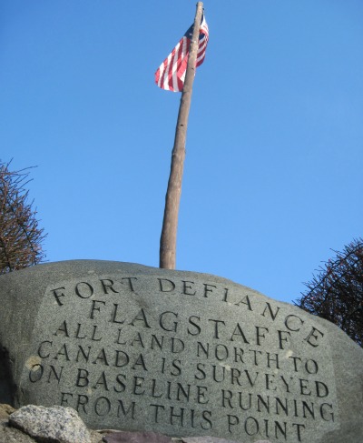
Edward Tiffin, Surveyor General of the Northwest Territory from 1815-1829, entered into a contract with surveyor Alexander Holmes on April 18, 1815, to establish the Michigan Baseline "due West from a point above Detroit." Holmes received permission to split the contract with his brother, Samuel. Tiffin also contracted with surveyor Benjamin Hough on April 28, 1815 to lay out "a true meridian line from Fort Defiance," which was also the beginning point of the Treaty of Detroit land cession. The Michigan Meridian was to coincide with the western boundary of the federally owned land.
Holmes' and Hough's contracts also specified how the military bounty land should be laid out. It would consist of ninety-six townships arranged in a rectangle measuring twelve townships tall by eight townships wide, centered directly over the baseline. Holmes was to outline the east forty-eight townships, and Hough had the west forty-eight. Other surveyors were contracted to subdivide the townships into one-mile sections.
These plans were all well and good, but government officials had apparently forgotten that the US was still at war with the First Nations who fought against it in the War of 1812. Although the US entered a peace agreement with Britain on December 24, 1814, the Native American tribes had never signed any such treaty. Alexander Holmes attempted to establish the Michigan Baseline in May 1815, but his work was cut short when the Native Americans he encountered in the field immediately sent him back to Detroit. The surveyors were forced to suspend all work for several months until peace could be made.
The Survey Begins
A truce with the local tribes finally came on September 8, 1815 with the signing of the Treaty of Springwells. By this agreement, everything more or less went back to the way it was before the War of 1812. Past treaties were recognized, and any chiefs who participated in the war were pardoned.
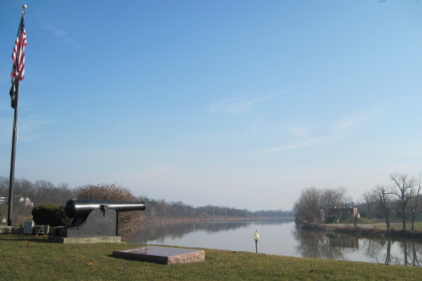
Hough and Holmes, whose contracts required them to finish their work by January 1, 1816, had to move quickly. Rather than survey the baseline and meridian separately as originally planned, they teamed up at Fort Defiance to begin work on the meridian, with the intention of splitting up and focusing on their respective tasks upon reaching Michigan's interior.
The surveyors and their crews arrived at Fort Defiance, Ohio in late September 1815. Their first task was to carefully observe the movement of the North Star in order to calculate the exact deviation between magnetic north and true north, which was found to be 4°39' east. They also had to determine, then and there, how far north the Michigan Baseline should be. In order to ensure that the military bounty land was not interrupted by Lake Erie or the Ohio border, the surveyors calculated that the baseline should run seventy-eight miles north of Fort Defiance. In other words, the spot where they began the survey of the Michigan Meridian at Fort Defiance was the southwest corner of the (theoretical) thirteenth township south of the baseline.
This process, of course, was utterly backwards, working in reverse toward a theoretical Initial Point. Because of this process, one could think of Michigan's true Point of Beginning as lying at the confluence of the Maumee and Auglaize Rivers in Ohio, where Fort Defiance once stood.
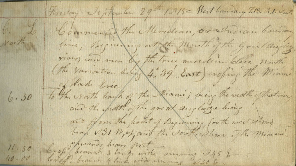
The first page of Hough's field notes, at the genesis of the Survey of Michigan, begins:
Friday September 29th 1815 - West boundary T.13 R.1 South
Commenced the Meridian, or Indian boundary line, Beginning at the Mouth of the Great Auglaize river, and run by the true meridian due North (the Variation being 4°,39' East) crossing the Miami of Lake Erie
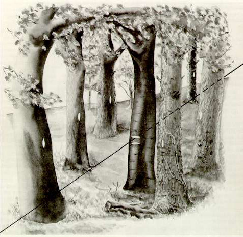
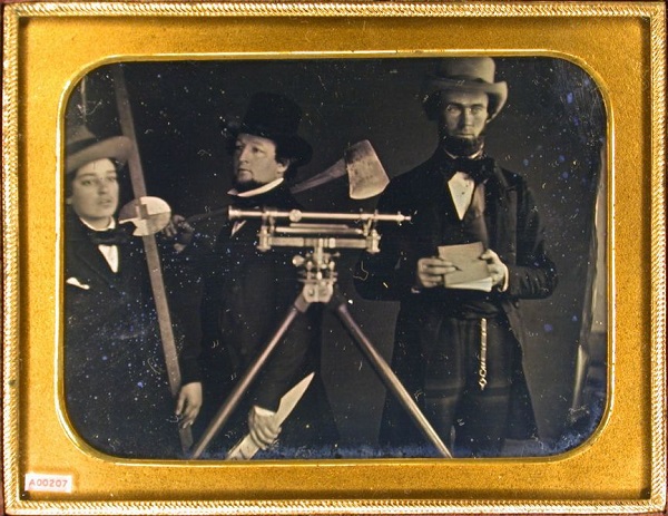
The surveyors worked their way north, using a Gunter's chain, a rod, and a theodolite to establish the meridian. Each surveyor required several assistants, including chainmen, an axman, a rodman, a counter, and a cook. The surveyors marked every half mile with a wooden post set firmly in the ground. Every tree close to the line was marked with a "blaze"--a smoothed area made by chipping away bark. Trees standing directly on the line were marked with deep horizontal hacks. And the entire process was carefully documented in the surveyors' field notes. These notes also included the locations of bodies of water, Indian paths, and other landmarks, as well as descriptions of the soil, topography, and vegetation.
The First Township
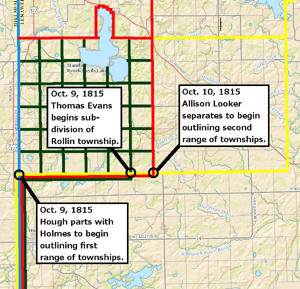
It was on or about October 9, 1815 when the surveyors struck the southwest corner of the military bounty tract. At this point, the various teams began to split up. Holmes continued running the meridian with the intention of reaching the Initial Point, and from there running the baseline toward Detroit. The rest of the group headed east along the southern border of the military land.
After just three miles, they came to Posey Lake. Establishing a theoretical line "through" the lake entailed moving around it along a carefully measured path and running calculations--a time-consuming process known as "meandering." As Hough approached the sixth mile east of the meridian, surveyor Thomas Evans stayed behind to begin subdividing the very first township of this tract, now known as Rollin Township, into one-square-mile sections. Evans later described this township as "very swampy and tedious to survey," and that, if the rest of the land was similar, "I shall not be able to finish it this Season." On the following day, Hough and his assistant, Allison Looker, separated in order to begin surveying the first and second range lines simultaneously.
When Hough began the survey of the north border of Rollin Township, he ran into an even larger body of water, Devil's Lake. In a letter to Tiffin he complained that this second lake
detained me another full day in going around it—This lake is from half a mile to 3/4 of a mile wide, and about 3 or 4 miles long, but the difficulty in meandering round those lakes is beyond any thing you can conceive—From what I have seen this country is in no ways inviting—It is true there is some good spots; but a large proportion is either useless swamps, or poor and barren—From there, the surveyors' experience did not improve. Because they did not realize that 1815 had been a particularly rainy year, they were led to believe that Michigan was mostly covered in swamps.
Starting the Baseline
Holmes continued the meridian north, closing in on the calculated Initial Point. However, his path was cut short just over seven miles from his destination by the Portage River, which was too flooded to cross. Being short on time and supplies, Holmes decided to descend to a point twelve miles south of the Initial Point and run a township line east and parallel to the baseline, rather than meander around the flooded river. He began this line on October 13, 1815, and ran it for forty-two miles in just five days.
On the sixth day, October 18, he continued the line east for only two miles, crossing the Great Sauk Trail less than half a mile before stopping on what is now the border between Canton and Van Buren townships. At this point there is a six-day gap in the field notes. Holmes probably followed the Sauk Trail to Detroit, where he and his men rested and stocked up on supplies, and where his brother, Samuel, was waiting to rendezvous with him.
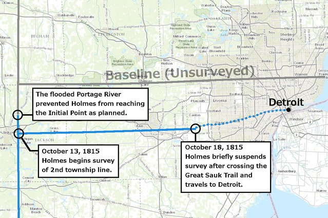
On October 23, Alexander and Samuel Holmes returned to the field to continue the survey. Samuel began at the post set by Alexander at what is now the southwest corner of Canton Township, and began running a range line north. Alexander resumed exactly where he left off, two miles east of Samuel's starting point. He continued to the southeast corner of Canton Township, then turned north, outlining the eastern edge of the military bounty land.
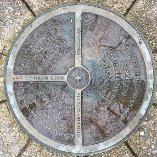
The following day, October 24, witnessed an important event in the urban planning history of Detroit. This was the date when both Samuel and Alexander Holmes, while surveying their respective range lines northward, set the very first monuments on the Michigan Baseline. Alexander met the baseline at the exact corner where Farmington Hills, Livonia, Northville Township and Novi meet. The post set by Samuel now marks the intersection of Napier Road and Eight Mile Road. Eight Mile Road, of course, coincides with the Michigan Baseline, and in many places is called Base Line Road.

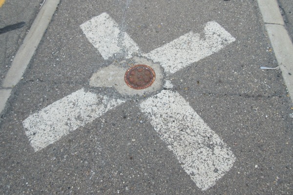
The exact spot where Alexander Holmes set his first post on the baseline is still marked on the median in Eight Mile Road between Haggerty Road and I-275.

The original wooden post is long gone, but this location has been carefully maintained for more than two centuries, having been replaced at times with monuments of other materials. Today it is marked by a length of 5/8"-diameter rebar driven into the earth topped with a brass cap. This marker is protected by a cast iron cover called a monument box. Even if you haven't noticed them before, monument boxes can be found every half mile on paved roads that follow lines of the US Public Land Survey System. They are easiest to find in the middle of the intersection between two of these roads.
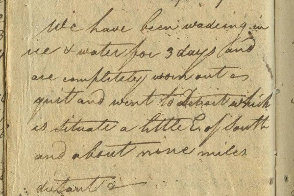
The Holmes brothers spent several weeks outlining townships in the northeast corner of the military bounty reserve. Alexander's group met the baseline again on November 13, at what is now the southwest corner of South Lyon. He finally began his survey of the baseline itself from this spot the following day. The team hacked their way eastward through half-frozen swamps until November 18, at a point a little more than one mile past the Saginaw Trail. Alexander Holmes' field notes indicate that a half-mile post was set at what today would be halfway between Livernois and Woodward avenues, on the border between Detroit and Royal Oak. He writes: "We have been wading in ice & water for three days and are completely worn out -- quit and went to Detroit which is situate [sic] a little E. of South and about nine miles distant."
Alexander Holmes withdrew from the survey and rested in Detroit for a week and a half. "We have suffered almost every hardship, and encountered almost ever[y] difficulty that could be expected of mortals to endure," he wrote to Tiffin while recuperating in Detroit, "but amidst all have been bless'd with good health.—It is my intention not to quit until I finish, which I hope to accomplish before the 20th of next month."
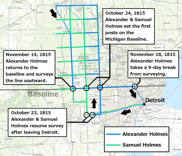
Lines surveyed by the Holmes brothers between Oct. 23-Nov. 18, 1815.
Alexander Holmes did not complete the baseline to Lake St. Clair, but returned to the military bounty tract on November 27. Although the Holmes brothers continued to work through mid-December, Hough departed for his home in Ohio some time prior to November 24. On November 30, Tiffin reported to Josiah Meigs, Commissioner of the US General Land Office, "The surveyors who went to survey the military land in the Michigan Territory have been obliged to suspend their operations until the country shall be sufficiently froze so as to bear man and beast." He noted that the surveyors had
continued at work, suffering incredible hardships, until both men and beasts were literally wore down with extreme sufferings and fatigue. The frost set in early, and the ice covered nearly the whole country, but broke through at every step, and the pack horses could not be got along with them.
Setting the Initial Point(s)
The land was adequately frozen by February 1816 when surveyor Joseph Fletcher arrived at Detroit to lay out the Ten Thousand Acre Tract as well as assist with the public land survey. Fletcher completed Hough's assigned portion of the bounty tract in September 1816, but it is not clear whether Fletcher subcontracted the work from Hough, or if Hough simply quit. (Fletcher would also re-survey the baseline east of what is now Haggerty Road in September 1816.)
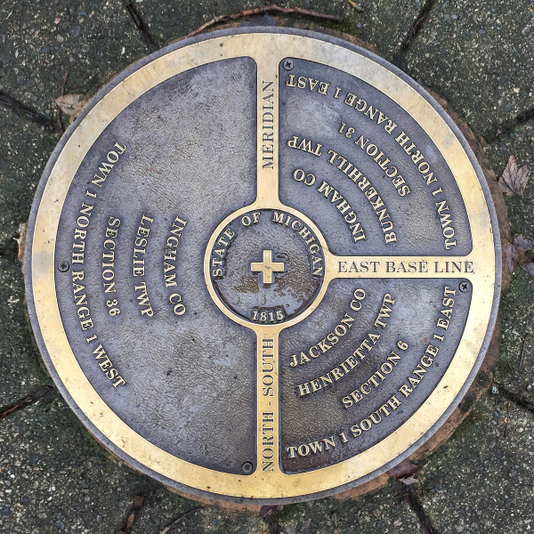
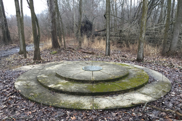
Hough returned briefly in early 1816 to complete the few lines that included Michigan's Initial Point. Because of the flooding of the Portage River, he couldn't directly carry the meridian north to that location, but instead had to backtrack westward along the baseline. The point where Hough set a post in the earth to indicate the center of the survey of Michigan is today marked by a concrete monument and bronze marker.
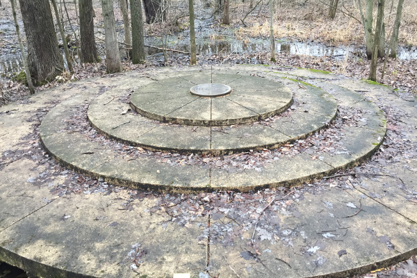
This is the precise spot where the baseline--running from Lake St. Clair and through Eight Mile Road--intersects the meridian, which began at Fort Defiance.
Eight years after Hough established this point, surveyor Joseph Wampler was tasked with beginning a survey west of the meridian, after that land had been obtained from the First Nations. He began on the meridian twelve miles below the Initial Point and headed north. However, unlike his predecessors, he was able to cross the Portage River and continue along the meridian directly. In doing so, he found that Hough had made an error when locating Initial Point. Hough's post was 935.88 feet north of where it should have been. In the map below, notice that the survey lines based on Wampler's work (on the west) and the lines based on the work of Hough and Homes (on the east) tie in to one another south of the Portage River, but not north of it.
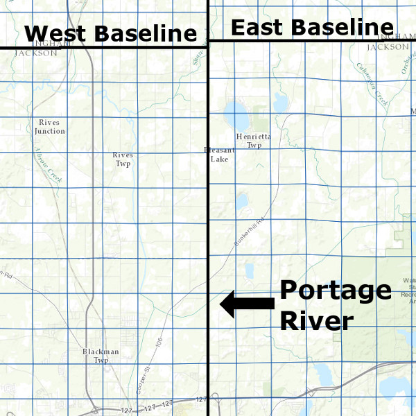
For reasons that will forever remain a mystery, Wampler decided to set a second initial point rather than tie his survey into the true point of beginning set by Hough. Therefore, Michigan has two Initial Points, the only state in the union to hold such an honor. Like the East Baseline, the West Baseline is marked by a monument and bronze disc. These sites are open to the public at Meridian-Baseline State Park.
The West Baseline terminates at Lake Michigan in the City of South Haven.
"Not more than one acre out of a hundred"
By the early spring of 1816, the townships comprising the military bounty lands were outlined and many were subdivided, albeit hastily. Below is a map showing all exterior township boundaries surveyed that season as determined by examining the surveyors' field notes, preserved by the Archives of Michigan and available to view on SeekingMichigan.org.
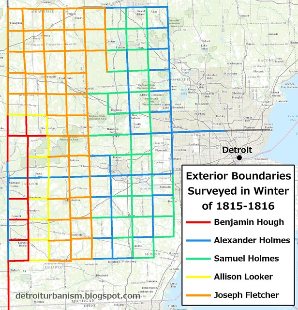
Click here for a larger version.
On November 30, 1815, when this survey was only half finished, Edward Tiffin made a report to Commissioner Meigs on the condition of this land. His summary is based on the incomplete information given to him by the disgruntled Benjamin Hough and Alexander Holmes. Tiffin described the territory as swampy and worthless. "The intermediate space between these swamps and lakes," he wrote, "which is probably near one-half of the country--is, with very few exceptions, a poor, barren, sandy land, on which scarcely any vegetation grows, except very small, scrubby oaks." His report famously concluded: "there would not be more than one acre out of a hundred, if there would be one out of a thousand, that would in any case admit of cultivation."
Tiffin's report led to a law passed by Congress in April 1816 substituting land in Illinois and Missouri to be used for military bounties instead.
This vast surveyed tract was simply to be sold to the public at a later date. But with Tiffin's damning report and the isolation of these two million acres in the middle of the peninsula, it seemed unlikely that the struggling territory could attract the settlers it needed.
To be continued...
Click here to read The Grid Part II: The Survey of Metro Detroit.
Regarding the Military Bounty lands, you stated that it was for service in the Revolutionary War. It was actually for encouragement for enlistments in the War of 1812. The link in your post shows it was part of the plan to increase the military establishment for the war.
ReplyDeleteThis part has always confused me. Some accounts do cite the War of 1812, but the war didn't begin until after that was was passed. I need to re-read the legislation and then correct/clarify the post. Thanks for pointing this out!
DeleteHi Paul,
ReplyDeleteThanks for your utterly fascinating and painstaking research into SE MI survey history. I have a quick question - I was long under the impression that Detroit's Point of Origin was the basis of the Baseline that now is Eight Mile Road at the northern boundary of the city.
If this is not the case, then is it just coincidence that the baseline is exactly eight miles due north of the POI? Or am I mistaken about that also?
Any help you can provide is greatly appreciated, and thanks again for the great research. The Meridian/Baseline marker(s)in mid-Michigan are now on my bucket list.
For a long time I believed that there was a connection between the Campus Martius Point of Origin and the USPLSS grid in Michigan. But it does appear to be only a coincidence that the Point of Origin is only about 200 feet off from where a section division line would run if it was continued into what is now downtown Detroit. There are other coincidences -- one line happened to end right at the riverside cabin of the Wyandotte Chief Walk-in-the-Water, and a township line happened to run straight through Fort Gratiot.
DeleteThe names of the mile roads are still of course numbered after how many miles away they are from downtown Detroit. In seeing them pop up in old news stories and other documents, they seemed to start off informally ("the seven-mile road") and later became formal names ("Seven Mile Road").
Is there any relationship between the Michigan Baseline and the Illinois-Wisconsin border? To me, they always looked aligned, and it was easy to believe that the border was an extension of the Baseline. But after reading this story, it's now clear that they the Illinois-Wisconsin border is a few miles north of the baseline. But still very close... any relationship?
ReplyDeleteAlthough I've heard that there was some connection between the two, I've honestly never taken a deep dive into exactly why the Illinois-Wisconsin border was drawn where it was, other than to ensure Illinois had the highest possible population. I think it's just a coincidence that they're within a few miles of one another.
DeleteThis is truly an amazing post and the research is magnificent. Fellow land surveyors on landsurveyorsunited.com will love having a read of this.....will certainly share.
ReplyDeleteIt seems a good survey and research report. It will be really helpful for readers. Thanks for sharing. long term jfk parking deals
ReplyDeleteNice post....
ReplyDeleteHire the best Land Surveyor in Dallas at CBG Texas LLC. Our Land Surveyors work with you to ensure that all of your surveying needs are taken care of and receive the best quality and service. Land Surveyors near me
I'm Абрам Александр a businessman who was able to revive his dying lumbering business through the help of a God sent lender known as Benjamin Lee the Loan Consultant of Le_Meridian Funding Service. Am resident at Yekaterinburg Екатеринбург. Well are you trying to start a business, settle your debt, expand your existing one, need money to purchase supplies. Have you been having problem trying to secure a Good Credit Facility, I want you to know that Le_Meridian Funding Service. Is the right place for you to resolve all your financial problem because am a living testimony and i can't just keep this to myself when others are looking for a way to be financially lifted.. I want you all to contact this God sent lender using the details as stated in other to be a partaker of this great opportunity Email: lfdsloans@lemeridianfds.com OR WhatsApp/Text +1-989-394-3740.
ReplyDeleteHello everyone, I'm Patricia Sherman in Oklahoma USA right now. I would like to share with you my experience of borrowing USD $185,000.00 to clear my bank draft and start a new business. It all started when I lost my house and I took my stuff because of the bank policy and I met some bills and some personal needs. So I became very desperate and started looking for funds in every way. Fortunately for me, a friend of mine, Linda told me about a credit company firm, I was intrigued by the fraud, but I was intrigued by my situation and had no choice but to get advice from my friend about this company. contacting them really doubted me because of my past experience with online lenders, did you know that little? '' Elegantloanfirm@hotmail.com This company has been very helpful to me and my colleague and today, thanks to this credit company, the proud owner of well-organized work and responsibilities, they smiled back at me. So if you really need to grow or start your own business, or if you really need to borrow money in any financial hardship, we recommend you find a financial development opportunity in your business today. {E-mail:} Elegantloanfirm@hotmail.com ... online for credit not a victim of scam. Thank you.
ReplyDeleteVery good info about Land Surveying. Such a very helpful post for every one. Thanks for sharing.
ReplyDelete