
What is the oldest human-made structure in Detroit? Many people would say it's the Charles Trowbridge Residence, or possibly the James Smith Log House. But couldn't you say it's the burial mound located on the grounds of Detroit's Historic Fort Wayne? Human remains more than one thousand years old were removed from the mound in the 1940s. But this earthwork of sand and topsoil may not fully be what it appears.
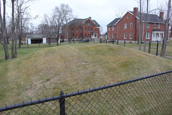
The Fort Wayne Mound.
Photo courtesy Timothy Boscarino, City of Detroit Legislative Policy Division.
The oldest burials at this site date to the Late Woodland Period. It was originally constructed at a time when the Hopewell civilization of the American Midwest was rapidly increasing in size. People were turning away from nomadism and toward a way of living centered around farms and cities. The most prominent urban center of this civilization was the city of Cahokia, located east of what is now St. Louis. In the 13th century, Cahokia reached a population as high as 40,000--larger than the city of London at the time.
The monument at Fort Wayne was not alone. Before the 19th century, it was only one of several burial mounds built on a large sand hill that used to lie just north of the confluence of the Detroit and Rouge Rivers. The hill was about 300 yards wide, nearly three quarters of a mile long, and rose twenty-five feet above the shore. The French called this area "Belle Fontaine" because of the abundant freshwater springs that gushed from the side of the hill. The British called it "Spring Wells". The name was retained by the Americans when the area was incorporated as Springwells Township in 1818.
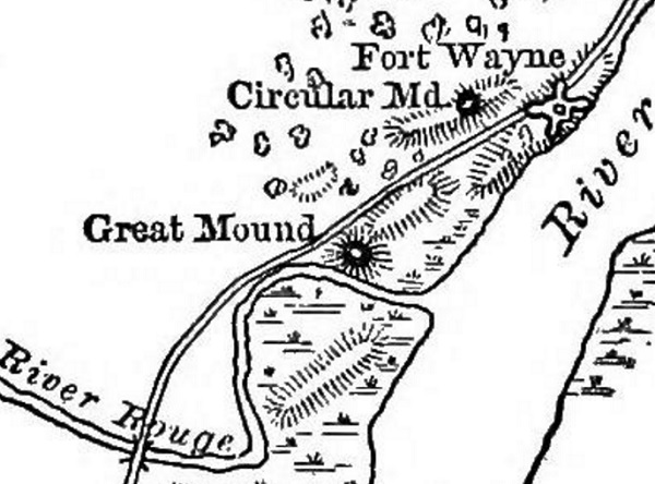
At least three burial mounds were built on the sand hill at Springwells. Farthest to the southwest was the Fort Wayne mound. On the northeast end was the Copper Works Mound, so called because it was adjacent to a copper smelting operation. In between the two was the Central Mound. Northwest of the great sand hill was Carstens' Mound, also called the Circular Mound. Southwest of the sand hill was a mysterious circular enclosure called the Springwells Earthwork. Near the north bank of the Rouge River, about one half mile from the shore of the Detroit River, was the Great Mound of the River Rouge.
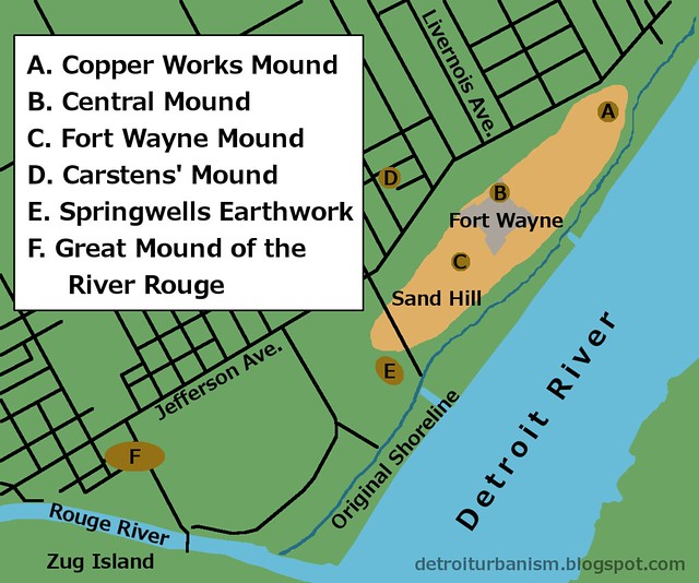
The Springwells Mound Group.
It was well known to the early French settlers that the sand hill at Springwells was a burial ground. Although the mounds were started by a lost civilization distinct from any culture known to early Detroiters, tribal nations in the early nineteenth century adapted the site to their own burial customs. Benjamin Whitherell, who came to Detroit in 1808, recalled:
In my childhood I have seen the children of the wilderness deposit the remains of their departed friends in [the hill's] bosom. They scooped out a shallow grave in the center of the top of the mound, and covered the body with some sand, brought from the neighboring sand-bank....
At different times the Sacs, Sioux, Foxes, Winnebagoes, Menominees, Iowas, Wyandottes, Pottawattomies, Chippewas, Tawas, and other tribes, congregated at this favorite spot, and made the night hideous with discordant yells. Here they held their war and medicine dances, and all sort of wabe-nos. Their music was the monotonous sound of the rude drum, beaten with unvarying stroke, for many hours together, frequently all the night long. It was done to drive the evil spirit off, and sometimes indicated that a warrior was laid in his grave....
The Sand Hill Mounds
Whitherell described the three mounds on the sand hill as being roughly the same size: about ten feet tall and thirty feet in diameter. He estimated the Fort Wayne Mound to be the oldest, as it was covered with large oak trees in his his earliest memories. The Central Mound was covered with smaller oaks. The Copper Works Mound, however "was of a more recent date, and on it was neither tree nor shrub."
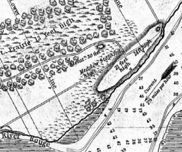
The sand hill at Springwells.
From a map of Springwells Township by J. N. Macomb and W. H. Warner, 1841.
Image courtesy Commonwealth Cultural Resources Group, Inc.
These mounds were being pillaged at least as early as 1817. That year, Samuel Brown published The Western Gazetteer; Or Emigrant's Directory, in which he stated that one of the mounds had been partially excavated, and that "bones, stone-axes, arrow-heads &c. were found in abundance." Thomas McKenney, the U.S. Superintendent of Indian Affairs, came to Detroit and visited the mounds on June 19, 1826. The monuments were rapidly deteriorating even then:
There appears to have been three of them, but only one retains much of its original conical figure, and this, like the other two, is fast finding its level. A principal cause of the mounds wasting away, is, the cattle go upon them to get into the cooler, fresher air, which blows upon them from the river, near the shore of which they are--and to get rid of the flies. The soil being light and sandy, is kept stirred by them, and the rains wash it off. Hence the exposure of human bones from time to time, as the several layers, or strata, are reached; for they appear to have been buried at different depths, and upon one another. I picked up some ribs, a bit of an os frontis, a piece of vertebrae, but all in a state of decay, so much so, that they crumbled at the touch.
John T. Blois, in his Gazetteer of the State of Michigan, documented his excavation of the Central Mound in the spring of 1837. He reported that the mound was eight feet high, and its surface contained fragments of pottery, bone and teeth. Two and a half feet below the surface he found six skeletons buried among arrowheads, stone axes, and other implements. Closer to the base of the mound he unearthed six additional skeletons, all buried in kneeling postures, facing north, and each holding a large clay vessel. Among burials were found tools and jewelry made from stone, quartz, animal bones, and sea shells.

A diorama of a burial mound in Ohio. (Source.)
Naturalist and historian Bela Hubbard, who came to Detroit in 1835 at the age of twenty-one, wrote in Memorials of Half a Century that one of the mounds (probably the Copper Works Mound) had already been ruined by the time he first saw the site. The Central Mound remained ten feet high with a diameter of forty feet, "though injured by pilferers of Indian relics." It was rapidly being leveled by excavations for gravel and clay for the Springwells brick yards. "On and around this spot," he wrote, "for the extent of an acre, were thickly strewn bones and broken pottery, mingled with shell beads, stone knives and arrow-points."
In an odd twist, the need for a new fort at Detroit would doom one of the remaining sand hill mounds but help preserve the other. In 1815, Duncan McArthur, Commander of the Army of the Northwest, wrote to Secretary of War James Monroe: "In my humble opinion, the Fort at Detroit should be destroyed and a strong picketted work erected at Spring Well." The sand hill was an ideal site, being on high ground, at the only bend in the Detroit River, and at the river's narrowest point. Fort Wayne was finally constructed in the 1840s, laying waste to the Central Mound in the process. In 1965, archaeologists excavating the north glacis of the fort discovered some fragments of prehistoric artifacts and human bone, and concluded that material from the ruined mound was used in constructing the embankment.
The Fort Wayne Mound
Hubbard remembered the Fort Wayne Mound in the 1830s was six feet tall and covered with trees. For a time its position on government land kept is safe from both archaeologists and real estate developers. The fort's officers quarters were simply built alongside it.
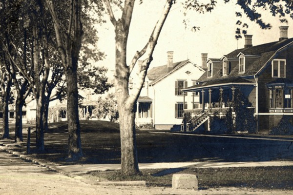
Undated photo of the Fort Wayne Mound in front of Officers' Row.
Image courtesy Burton Historical Collection, Detroit Public Library. (Source.)
The mound would not be safe forever. Ethnologist Henry Gillman received permission from the War Department to open it in late 1875 and began an excavation with the Detroit Scientific Association on May 22, 1876. His report noted that the mound remained about five feet tall, and that it had been sodded six years prior in order to prevent further erosion. Gillman's team cut a seven foot wide trench through the center of the mound running east to west, then ran two additional trenches from the center to the south and north. The excavation yielded the usual items--human bones, pottery, stone and quartz tools, etc. At what was believed to be the center of the mound, Gillman discovered a clay urn that contained cremated human remains, a copper knife, and two seashells. In all he recovered sixteen burials.
The Springwells Mound Group.
From The Mound-Builders and Platycnemism in Michigan, by Henry Gillman
Around 1920, then-quartermaster of Fort Wayne, Franklin Lamb, was curious about the mound and decided to dig into it. This incident was revealed during a 1921 trial when Lamb was accused of arson at the fort. According to a March 19, 1921 story in the Detroit Free Press, Lamb reported his findings of "perfect specimens of Indian pottery, weapons and all sorts of utensils" to the war department, but received an order from the secretary of war to "restore the mound to its original condition," citing "an old treaty between the United States and the Indian tribes formerly located in Michigan" which dictated that "burying places and stores of the native found should not be disturbed." The article did not name the specific treaty referred to, and no other information about this event has been found.
Over the years, Gillman's and Lamb's excavations were forgotten, and all that were remembered were vague rumors of the mound being somehow related to human burials. In 1944, the fort's commandant, Col. Harry Adamson, requested and received permission to determine exactly what the mound was. (By then it was being been used as a children's playground.) The excavation began on July 1, 1944 by the Aboriginal Research Club of Detroit, a group organized in 1935 by artifact collectors, and loosely affiliated with the University of Michigan. Their excavation began at the sidewalk that cuts through the base of the mound on its north side, and they soon discovered fragments of bone, pottery, and stone tools.
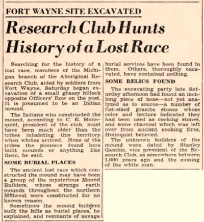
Excerpt from the Detroit Free Press, July 2, 1944.
Not long after their work began, Gillman's report was rediscovered, and the team's approach was altered. They would begin at the west end of the site and work their way east, almost completely excavating the entire mound. They worked through the summer and autumn of 1944, breaking for the winter. Work resumed on May 20, 1945 and again continued through the autumn. Every object and all human remains that were taken from the mound were handed over to the University of Michigan.
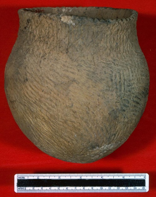
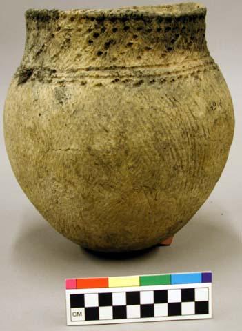
A clay vessel taken from the Fort Wayne Mound by Holmquist's team.
Image courtesy University of Michigan Museum of Anthropological Archaeology.
After the excavation was complete, the mound was "restored" with a bulldozer and steam shovel, and the final shape was touched up with hand tools. This work was completed on November 4, 1945. The sandy mound was later covered with topsoil and seeded to prevent erosion. The report by Carl E. Holmquist, president of the Aboriginal Research Club, notes that the site is "still...a burial mound" because "some human remains" were left beneath the sidewalk that skirts the northern side. Evidently he did not want to disturb the pavement.
If you visit the site today, you will see that a portion of this sidewalk has been removed. However, according to Historic Fort Wayne's manager, James Conway, the remains that were beneath the pavement were left intact.
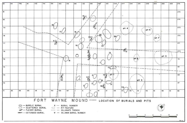
A plan of Holmquist's 1944-45 excavation, also showing Gillman's 1876 trenches.
From The Springwells Mound Group of Wayne County, Michigan, by John R. Halsey,
published in Anthropological Papers No. 32, University of Michigan.
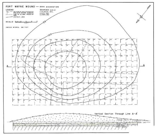
From The Springwells Mound Group of Wayne County, Michigan, by John R. Halsey,
published in Anthropological Papers No. 32, University of Michigan.
Between Gillman and Holmquist, approximately fifty human remains were taken from the Fort Wayne Mound. Some were flesh burials, others were buried as bundles of bones denuded of flesh. Among the skeletons whose sex could be identified, burial goods were only present with women. Women outnumbered men among those who died young, and men outnumbered women among those who died old. Researchers speculate that this is due to a combination of childbirth trauma and a division of labor that unfairly burdened women.
Radiocarbon dating was performed on some of the samples retrieved. Material from a "bundle" burial dated to the year 1159 A.D. A bone sample from an individual burial--a woman who had died at about the age of 18--dated to 750 A.D.
Carstens' Mound
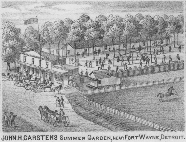
John Henry Carstens was born in the German state of Holstein around 1820 and fled to the United States after the failed 1848 revolutions in Europe. He opened a saloon with outdoor recreation facilities across the road from Fort Wayne at the intersection of Jefferson Avenue and Crawford Street.
(Source.)
In the summer of 1870, workers dug into a sandy knoll on Carstens' property in order to set up a target practice area for the German Sharpshooters Society. In the process human remains and "Indian relics" were unearthed, and it was discovered that this hill was in fact another burial mound. Bela Hubbard and others referred to this site as "Carstens' Mound," but Henry Gillman called it the "Circular Mound."
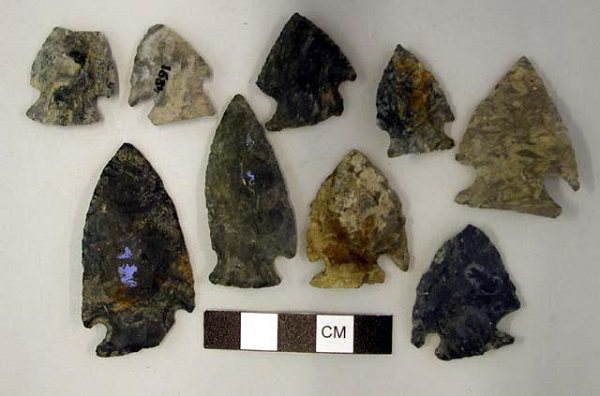
Chipped stone projectile points taken from Carsten's Mound in 1870.
Image courtesy Peabody Museum of Archaeology and Ethnology.
Carstens removed twelve skeletons from the mound in addition to pottery, clay pipes, tools of stone and animal bone, a copper necklace, and a nine inch long copper awl. Mr. Carstens put these items out on display at his beer garden.
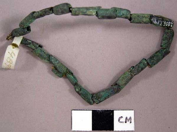
Copper beads taken from Carstens' Mound in 1870.
Image courtesy Peabody Museum of Archaeology and Ethnology.
Around 2008, archaeologists from Commonwealth Cultural Resources Group, Inc. of Jackson, conducting an archaeological impact study for the Detroit Riverfront International Crossing, attempted to find some trace of the mound. They excavated the area where it was believed to have been, but no evidence of prehistoric artifacts was discovered. (Their very interesting reports can be read here: Part 1 | Part 2)
The Springwells Earthwork
Southwest of the great sand hill was an expansive marsh, in the middle of which was several acres of dry land adjacent to the Detroit River. On this land was a circular enclosure standing between three and four feet tall and encompassing about an acre and a half. Brown's 1817 Western Gazetteer describes it as "the remains of an ancient fortification", although it was probably not used for defensive purposes. Blois and Hubbard also described this earthwork, noting that an opening faced the Detroit River, and that two straight parallel embankments a few feet apart had been built over the marsh to connect this land to the sand hill. Hubbard wrote that the earthwork was not haphazardly formed, remarking instead that "the regularity of the work marks it as one of studied design."
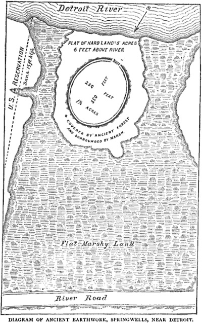
The Springwells Earthwork.
From Memorials of a Half-Century by Bela Hubbard.
In 1889, a writer for the Detroit Free Press noted that the Springwells Earthwork was still in a "tolerably good state of preservation," and might be an interesting attraction for attendees of the nearby Detroit International Exposition (Free Press, 20 Oct 1889). But in 1903, the Detroit Edison Company purchased this land in order to construct a power plant. If any remnant of the earthwork existed at that time, it was certainly wiped out by the excavation for the building's foundation. The photo below shows this site from the southwest looking northeast in 1898. The structure on the river appears to be a boathouse on land owned by George Webber adjacent to the fort. One of the clusters of trees pictured here might mark the location of the earthwork, as Hubbard noted that "ancient oaks and rambling grape-vines (were) its sole occupants" when he first visited it.
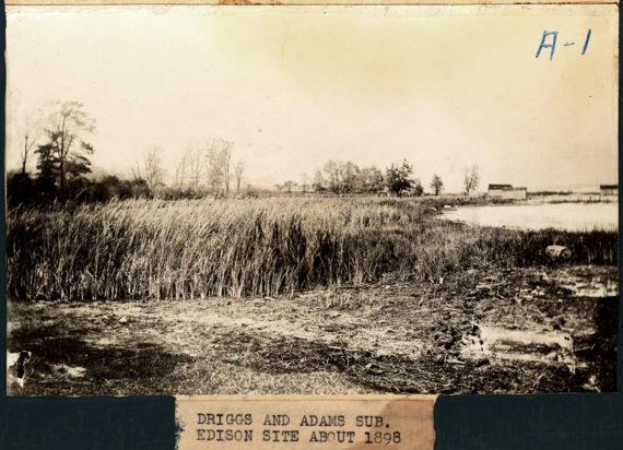
A cluster of trees likely mark the location of the Springwells Earthwork.
Image courtesy Burton Historical Collection, Detroit Public Library (Source.)
Click here for a different photo of the same location.
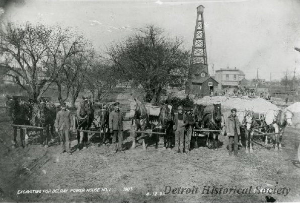
Teams preparing to excavate for the foundation of a power house for Detroit Edison in 1903. The ancient Springwells Earthwork was probably razed at this time.
Image courtesy Detroit Historical Society. (Source.)
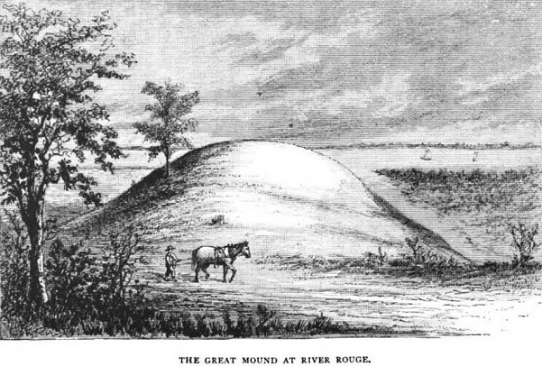
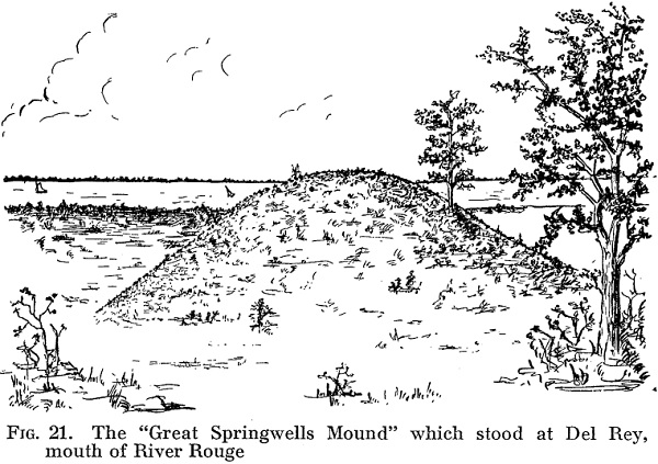
The Great Mound of the River Rouge
Dwarfing all other burial mounds in the vicinity was the massive Great Mound of the River Rouge, located in what is now Detroit's Delray neighborhood. Gillman estimated that it originally measured 200 feet wide by 300 feet long--covering more than an acre--and standing forty feet tall. But it may have been even larger. In researching this mound, Hubbard consulted longtime Delray resident Augustus D. Bordeno around 1885, and more than thirty years later archaeologist Harry L. Spooner interviewed Bordeno's son Louis. (Spooner's research appeared in a September 28, 1919 piece in the Detroit Free Press as well as an article in the Summer 1931 issue of Michigan History Magazine.) According to the Bordenos, the mound was a massive 400 feet wide and 800 feet long.
From Memorials of a Half-Century by Bela Hubbard.
Most of the mound sat on a ribbon farm designated Private Claim 718 after the United States took command of Detroit. The U.S. land patent was issued to John Askin, who died in 1815. Two years later his widow, Archange Askin, sold the farm to Cornelius Leonard Lenox, an African American former slave who came from Newton, Massachusetts with Michigan's first governor, William Hull. Lenox died in 1853, and his widow, Candis Lenox, sold the portion of the farm south Jefferson Avenue to James W. Sutton in 1860. The south two-thirds of this land was then sold to Henry Barns in 1864. Barns briefly operated the Detroit Improved Brick Company here before selling the property to the Detroit City Glass Works in 1868. The following year, the Detroit Free Press noted: "Flint arrow heads--Indian relics--are frequently found on the large sand mound at the River Rouge, near the glass works." (17 Oct 1869)
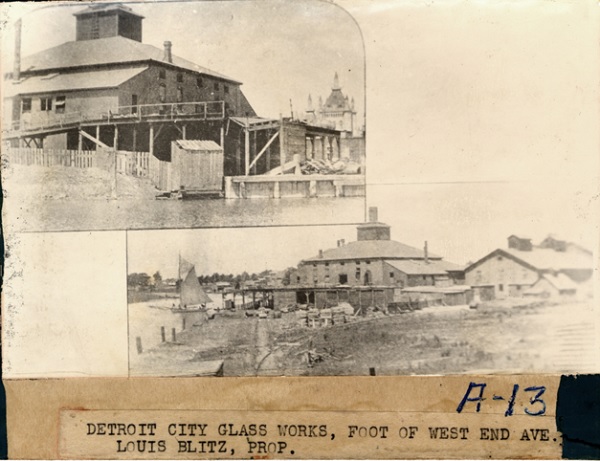
Image courtesy Burton Historical Collection, Detroit Public Library. (Source)
According to Louis Bordeno, the parcel containing the mound came into the possession of "the Chase estate"--probably Elisha and Caroline Chase. Because the sand could be used to make mortar and served other building purposes, the Chases hired Augustus Bordeno and his son to dig down the mound, boat the sand up to the docks at Detroit, and sell it for 2½ cents per barrel. Louis Burdeno estimated conservatively that he and his father removed 1,300 skeletons from the burial mound. "When the diggers came to a skeleton," Spooner wrote, "they put it on a wheelbarrow, wheeled it to the [Rouge] river, and dumped it in." Perhaps some of these survived further decay, and now lie beneath several feet of river sediment. If the Bordenos' estimate of the mounds' size is correct, then it must have contained something like six million cubic feet of sand. Its desecration had to have taken place over many years by dozens of individuals. By the time Gillman and Hubbard wrote of the mound in the 1870s and 1880s, its height had been reduced to 20 feet. "For nearly half a century," Hubbard lamented, "portion after portion has been dug away and removed, by wagon load and boat load, and little notice taken of its contents, until now it is but a miniature of its former self.... [T]housands of fragments of human bones still lie bleaching on the sand."
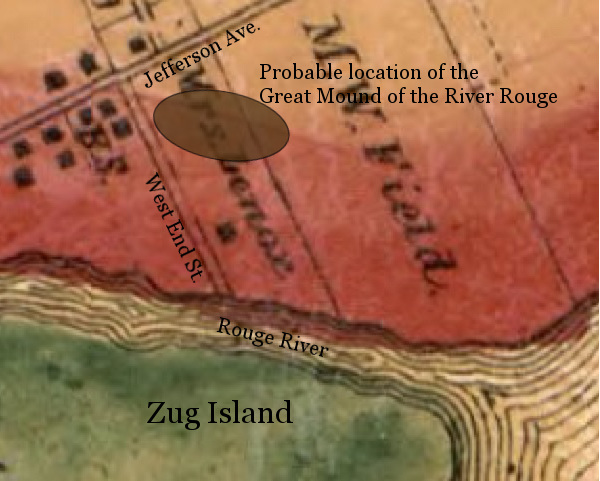
The likely position and location of the Great Mound, shown here at 400 by 800 feet,
superimposed over an 1860 plat map of Wayne County.
The vast number of skeletons found within this mound is consistent with the practice of the Huron Feast of the Dead. The Huron / Wyandot people would gather every ten to fifteen years, disinterring relatives who had died since the last festival and bringing their bones, bundled in beaver furs, to a sacred communal burial site.
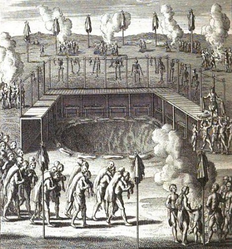
A 1724 depiction of a Huron Feast of the Dead.
From Moeurs des Sauvages Amériquains, by Joseph-François Lafitau.
Gillman made at least two excavations into the Great Mound, in 1869 and 1874. Hubbard was present during the one in 1874. These diggings showed that the mound began as a natural hill of gravel and sand perhaps ten feet high. The upper thirty feet were built up by human hands over the course of centuries. As each burial took place, more sand was brought from the banks of the river to pile it even higher. To imagine the dimensions described by the Bordenos, picture an area the size of the two segments of Grand Circus Park combined, covered by forty feet of sand, bearing in mind that the upper three-quarters of this volume was placed there by human hands.
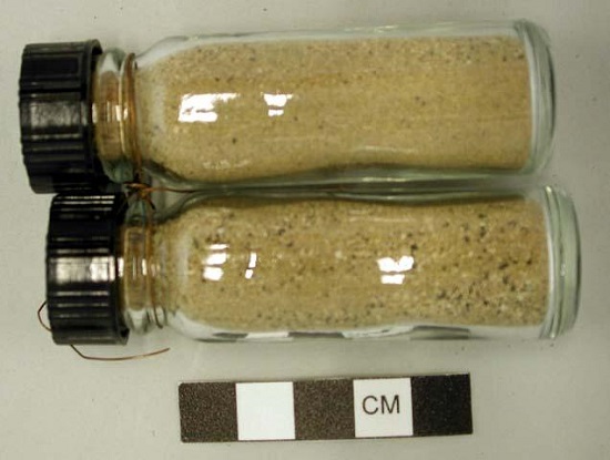
Sand from the Great Mound, donated to Harvard University by Gillman in 1869.
Image courtesy Peabody Museum of Archaeology and Ethnology.
Clay vessel donated to Harvard University by Gillman in 1872,
from either the Great Mound of the River Rouge or Carsten's Mound.
Image courtesy Peabody Museum of Archaeology and Ethnology.
"Since the burrowings of the scientists," complained the Free Press, "the sand of which the mound is composed has been taken up by the wind and carried about. ... The drifting sand became a nuisance to the people in the vicinity, and the owner the other day gave two lots for the hauling off and leveling of the land." (28 Jul 1878) Even still, a fragment of the Great Mound persisted for another decade, just to the east of Private Claim 718. The final blow was yet to come.
The Great Exposition
In 1889, a group of prominent Detroiters gathered to plan an immense agricultural and industrial fair that they would call the Detroit International Exposition. At a meeting on March 18, 1889, the stockholders selected a portion of the former Moses W. Field farm--which contained a remnant of the Great Mound--to purchase for the event. The investors bought the 69.96 acres from James McMillan for $140,000, and hired the architecture firm of Scott, Kamper and Scott to design the grand exhibition hall, claimed to be the largest ever constructed for an international fair. It would open on September 17, 1889 and last ten days.
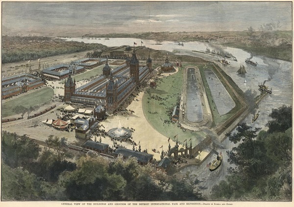
Illustration of the Detroit International Exposition grounds, exaggerated in size.
From Harper's Weekly magazine, August 17, 1889.
On May 9, 1889, the Free Press reported:
The excavators at work on the front end of the Field farm, the site of the exposition, yesterday unearthed the skeletons of a score of Indian braves, buried there in the days of Pontiac. An old knife and several strings of beads were among the find."The property was open to the general public in the summer months before the official opening of the exposition. Visitors were openly encouraged to pillage what was left of the mound:
Many curiosity seekers searched the grounds for relics, of which there are continual finds since the recent opening by one of the excavators of a well-filled Indian burial mound, and it is reported that several of the seekers were rewarded by discoveries of more or less value. As the work of ditching and grading proceeds fresh relics are liable to be exhumed every day." (Free Press, 2 Jul 1889)Also that year, four skeletons--two adults, one child, and one infant--unearthed from the site were given to an unnamed "local politician," who eventually donated them to the University of Michigan Museum of Anthropological Archaeology.
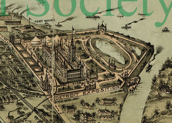
Another view of the Detroit International Exposition property, also exaggerated.
Image courtesy Detroit Historical Society. (Source.)
Casual weekend desecration of sacred burial sites was nothing new in Detroit. The sand hill at Springwells was a popular picnicking spot in the early 1800s, and the burial mounds were frequently hacked into by amateur treasure hunters. Thomas Palmer, writing of his childhood in Detroit in the 1830s, recalled:
"The banks [of the Detroit River] were covered with many Indian mounds, and my teachers used to take me down Saturdays often times to see them dig for Indian skeletons and the curios which had been buried with them. In my playhouse I had quite a collection of Indian heads which time had prepared for the museum or for jack-o'-lanterns."Of course, one did not need to visit the Springwells Mounds to disrupt a burial ground in Detroit's early days. In the 1830s, according to Hubbard,
"It was hardly possible to dig a cellar or level a hillock without throwing out some memorial of the red races... To unearth a human skeleton was a common occurrence. They were thrown out by spade and plough, and sometimes were seen protruding from the soil where the action of the waves had broken into the land."
From Archaeological Atlas of Michigan, by Wilbert B. Hinsdale.
The Detroit International Exposition remained an annual event for several years. Before opening in 1890, it was reported that the walkways throughout the grounds would be less dusty than before because they were to be covered with the great quantity of fine gravel "found under the center of one axis of where formerly stood the great prehistoric Indian mound." (Free Press, 29 Jun 1890) The destruction of the Great Mound of the River Rouge was complete.
The exposition company's stockholders sold the land to the Solvay Process Company, a soda ash manufacturer, in 1895. In the decades that followed, the surrounding property became industrialized beyond the imagination of anyone who ever saw the Great Mound with their own eyes. Delray residents suffer from some of the worst air pollution in the state. Local commercial activities include coke storage, rock salt mining, steel production, oil refining, yard waste composting, and sewerage treatment.
Two years before the Detroit International Exposition, Hubbard described the Great Mound as a "most picturesque" resting place, surrounded by meadows and a commanding view of what then remained mostly countryside:
"Still, as of old, the warm sunshine rests upon this spot; the sparkling waters lave its base; the winds blow over it from the not distant lake, scattering the dust that once animated human forms. But the beings these cheered in the olden time have all perished from the land; their history is but a fading dream, and the proud pile which they created to immortalize their memory has nearly disappeared, and will soon have vanished altogether, in the progress of an unheeding and remorseless civilization."
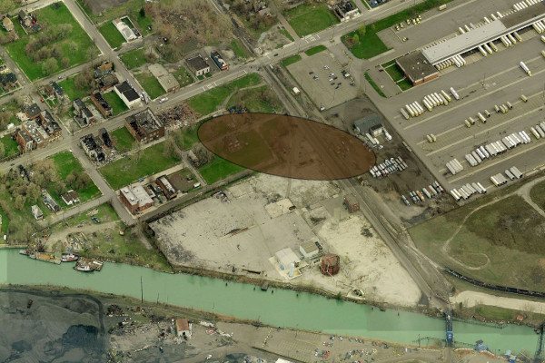
The approximate location of the Great Mound of the River Rouge today.
Image courtesy Bing Maps.
Desecration and Repatriation
It's an ugly fact of human history that when one group conquers another, the defeated nation is looted. Whether motivated by profit or by science, a colonialist mindset tends to rationalize the destruction of ancient burial grounds. Henry Gillman studied the early inhabitants of Detroit not as human beings equal to himself, but as an inferior "other"--a "lower" race. He noted a perforation in the skeletons' humeri, which in his words, "is most frequently met with in the negro race, has also been observed in the Indian, and, though not always present, is quite general in the apes, while it is seldom seen in the white races." In another paper he reiterates that this "Simian" or apelike characteristic, as he put it, "pertain in the largest degree to the lower races of man, while it is very rare or almost absent in the Caucasian." Regarding arm-to-leg ratios, Gillman claimed that a skeleton from the Fort Wayne Mound "approaches the simian proportions," citing "the greater length of the arm in the modern Indian and especially in the negro, as compared with the Whites." The sizes and shapes of the craniums were carefully recorded--the less they resembled the "dolichocephalic" shape of the Caucasian skulls, the more inferior they were deemed to be. Since Gillman, these remains have continued to be handled and stored in a dehumanizing manner.
In 1968, the University of Michigan loaned one of the skeletons taken from the Fort Wayne Mound to the museum that had since opened on the property. Native American activists asked that these human remains--tastelessly displayed in a glass case--be removed from public view. The museum eventually agreed to remove the exhibit, but shipped the bones back to the university rather than retun them to representatives of the Native American community. According to Survival and Regeneration: Detroit's American Indian Community by Edmund Jefferson Danziger, Jr., the University of Michigan ultimately relented, handing over two containers of human remains to Dean George of the North American Indian Association of Detroit in March of 1973. They were subsequently reinterred somewhere in Michigan.
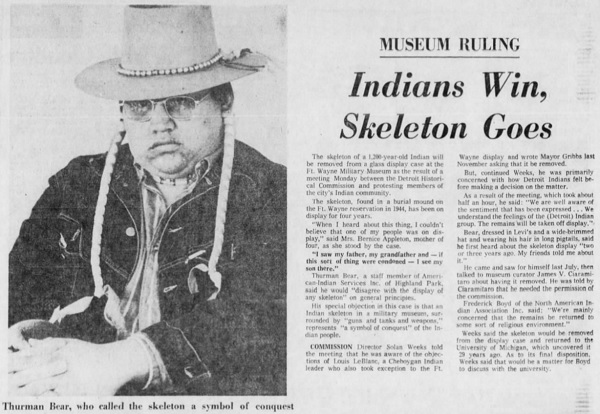
From the Detroit Free Press, February 6, 1973.
Countless incidents like this led to the Native American Graves Protection and Repatriation Act (NAGPRA) of 1990. NAGPRA requires institutions that receive federal funds to inventory the Native American human remains and associated funerary objects in their possession, and to return them to descendants or associated tribes. Because institutions clung to their holdings when a definitive tribal affiliation could not be determined, the law was strengthened in 2010. NAGPRA now allows a tribal nation to claim culturally unidentified human remains if they were removed from an area historically occupied by the tribe. In 1995, the Saginaw Chippewa Indian Tribe established the Nibokaan Ancestral Cemetery on their reservation by Mt. Pleasant specifically for human remains repatriated to them. The cemetery has since received and reburied hundreds of remains that had been unearthed from locations all over Michigan.
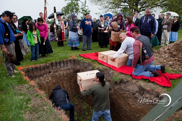
A repatriation ceremony at the Nibokaan Ancestral Cemetery, May 17, 2013.
Photo courtesy Marcella Hadden, Niibing Giizis Photography.
Some or all human remains taken from the Great Mound of the River Rouge and the Fort Wayne Mound by Gillman were donated to the Peabody Museum of Archaeology and Ethnology at Harvard University. Gillman also purchased the items taken from Carstens' Mound and donated most or all of them to the same institution. The four skeletons given to the unnamed "local politician" taken from the Detroit International Exposition site ultimately ended up in the University of Michigan Museum of Anthropological Archaeology, as did the approximately twenty-four distinct burials and remains from eight burial pits from the Fort Wayne Mound retrieved by Holmquist. The whereabouts of all other human remains taken from the Springwells Mound Group--aside from the thousands thrown into Rouge River--may never be known.
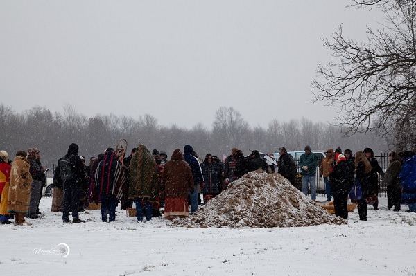
A repatriation ceremony at the Nibokaan Ancestral Cemetery, November 18, 2014.
Photo courtesy Marcella Hadden, Niibing Giizis Photography.
Below are data obtained from the National Park Service's NAGPRA database of culturally unidentifiable Native American artifacts. The remains of some individuals are unaccounted for, as the minimum number of individuals (MNI) of the Peabody artifacts add up to only 27, even though more than that had been obtained by Gillman. The numbers of associated funerary objects (AFO) are also indicated.
| Institution | Site | Accession # | Year Acquired | MNI | AFO |
|---|---|---|---|---|---|
| Peabody Museum | Rouge Mound Group | 69-31-10/22209.1 | 1869 | 6 | 42 |
| Peabody Museum | Rouge Mound Group | 69-31-10/2217 | 1869 | 1 | 0 |
| Peabody Museum | Rouge Mound Group | 72-7-10 | 1872 | 10 | 0 |
| Peabody Museum | Rouge Mound Group | 72-7-10/4908 | 1872 | 1 | 0 |
| Peabody Museum | Rouge Mound Group | 7-3-10/7120 | 1873 | 8 | 0 |
| Peabody Museum | Rouge Mound Group | 85-28-10/38225 | 1885 | 1 | 0 |
| Univ. of Michigan | Exposition Grounds | 99 | (unknown) | 4 | 0 |
| Univ. of Michigan | Fort Wayne Mound | 1629 | 1945 | 29 | 124 |
According to the University of Michigan's NAGPRA Project Director, Dr. Ben Secunda, physical possession of the four sets of human remains from the Exposition Grounds site was transferred to thirteen tribes collectively on May 16, 2014. The tribes authorized members of the Nottawaseppi Huron Band of Potawatomi Indians to accept the remains on behalf of the group. Dr. Secunda told me via email that the remains taken from the Fort Wayne Mound "are under the legal control of the U.S. Army and the University is assisting them in completing some of their work required under the NAGPRA law and regulations." Consultations with local tribes regarding these and other remains are ongoing, and there is not yet a set date for their transfer.
The ancient earthworks that stood on the shores of the Detroit River for more than a millennium were needlessly destroyed by a society that did not think they were worth caring about. The one survivor among them was essentially fully excavated and simply piled up again, making it debatable whether it truly is the oldest human-made structure in Detroit. The remains of thousands of human beings were thrown into the river or kept as souvenirs. The handful that remain are currently kept by institutions that have already repatriated many ancestry remains. Some day soon, the last of the bones taken so unceremoniously from the mounds at Springwells will be returned to the earth from which they came.
I haven’t heard of this before and it's sad to think of how human remains have been disrespected.The information you shared is interesting and I appreciate the education!
ReplyDeleteGreat job Paul! Well researched and thorough! I've been working on a long term Detroit mound project for years - have all the books / articles you've cited and more - would love to have a mound meeting sometime - cheers, Scott
ReplyDeletehttp://scotthocking.com/mound.html
Thank you, Scott! I did come across your site when researching this subject, and I am jealous of the images of the Hubbard and Gillman maps that you got by actually having the books! We should definitely keep in touch.
DeleteHi you two, encouragement to both of you to reach out to the tribes, who have much to say and may even add to your studies. I appreciate the caring tone a lot. I'm a NAGPRA rep for my tribe, and was involved in the return of these ancestors.
Deletewhy do you beary people
DeleteWonderfully done! Thank you
ReplyDeletevery comprehensive and well done, thank you. I will look for more from your site.
ReplyDeleteFantastic!
ReplyDeleteDo you announce new blog posts on Twitter? It's often how I surface news these days.
Thank you! I never did sign up for Twitter, but maybe it's time. For my last blog, I know some people just added it to their RSS readers. I probably won't update super often, but checking once a month should do it.
DeleteI recommend signing up for Twitter, then linking your blog to it so that whenever a new entry goes up, it automatically x-posts. Best of both worlds.
DeleteMore importantly, that was well-written, well-researched, fascinating, basically all-new to me, and I look forward to your next entry!
As the author of Zug Island, I find this post fascinating and validating.
ReplyDeleteFascinating read, thanks!
ReplyDeletein re: the Fort Wayne mound... the sidewalks mentioned were put down by the Army in the 1920's and they cover a cast iron gas main that was trenched out before the sidewalk was laid. Any remains Gilchrist left behind were no doubt lost during the trenching operation. In 1974 MICHCON gas retired the cast iron main inherited from the Army and used directional boring to install plastic mains on the river side of the sidewalk.
ReplyDeleteThat is interesting. I'm not sure to what extent Holmquist saw the remains that he said were beneath the sidewalk. But he reported that they were left there in 1945, so hopefully they are still intact. No doubt the 1920s operation probably did involve disinterring other skeletons.
DeleteHolmquist also reported the loss of about 20 feet of the mound itself to the sidewalk...when he hypothesized about the remains still being there he had no idea of the trenching operation, which surviving Army engineering records indicate as being 'extensive.' The rebuilding of the mound by bulldozer after Holmquist is also detailed in the records.
ReplyDeleteHolmquist also reported the loss of about 20 feet of the mound itself to the sidewalk...when he hypothesized about the remains still being there he had no idea of the trenching operation, which surviving Army engineering records indicate as being 'extensive.' The rebuilding of the mound by bulldozer after Holmquist is also detailed in the records.
ReplyDeleteI don't think Holmquist was merely speculating. His report says "the sidewalk...still covers some human remains which were located, but not removed."
DeleteVery interesting! Need to go take a closer look in person. Thanks for helping us connect to our rich past.
ReplyDeleteThanks so much for sharing this information about our area:)
ReplyDeleteThe link will take you to more information about the Tutelo in this particular area of whom the mounds belong. https://books.google.com/books?id=gBniAAAAMAAJ&pg=PA41&dq=Tutelo+Indians+originated+in+the+Detroit+area+of+michigan&hl=en&sa=X&ved=0ahUKEwiklrTErvPJAhVJ-2MKHX8fAZcQ6AEIJjAA#v=onepage&q=Tutelo%20Indians%20originated%20in%20the%20Detroit%20area%20of%20michigan&f=false
ReplyDeleteThank you Paul and Scott for your posts and links. This info helped me solve a riddle regarding a road in the area we live (Belleville). Tuttle Hill Road is a twisting (ie non European settler) path that stretches from the Huron River just south of Ypsilanti to almost the Raisin River just east of Dundee. Not coincidentally, there is a marker on the north side of the Raisin River commemorating what is said to be a Potawatomi burial ground. After reviewing your posts, I rather suspect it likely predated even the Potawatomi's arrival.
DeleteThis is awesome keep up the great work!
ReplyDeleteI so love reading about the history of Detroit and the Spring Wells area in the 18th and 19th century. My Martin family bought land about 1848 in Springwells Twp along Michigan Avenue. Appreciate all your hard work and research. Look forward to more articles by you. Than you so so much.
ReplyDeleteGreat stuff -- just a correction, Hubbard was 21 when he came to Detroit and took up residence on the old Knaggs Farms, PC 78, not 11 yo as stated above. He was born in 1814.
ReplyDeleteThanks for the correction! I've updated the post. :)
DeleteSo fascinating! Just to think how Detroit was before it was settled by Europeans jsut a mere few hundred years ago is mind blowing. Thank you very much for the historical information.
ReplyDeleteThank you for writing such an informative and thoughtful article! I have been to Fort Wayne and visited the mound but I never knew the whole story! I learned so much the place I call home (SW Detroit) - most of which my teachers never taught me! (Imagine that!) I was struck by the work of Henry Gillman (a respected and successful man of the time) and how clearly racism has deep roots in Detroit's history. I will be sure to share your work with my students!
ReplyDeleteThe Great Mound of the Rouge is misplaced on the map. That channel that created Zug Island was cut by Henry Ford to allow ships to deliver coal, etc. to the Ford plant on Zug Island Rouge Plant. The Great Mound was along the main channel of the Rouge River on the western side of what is now Zug Island. I have heard that when 40 foot high 300 foot long mound was eliminated, many of the artifacts went to the Museum of Natural History at U of M. Mound expert of the time, Dr. Wilbur B. Hinsdale, was the first director of the museum and author of the Archaeological Atlas of Michigan (1931) and Primitive Man in Michigan (1925). I teach Urban Economics at WSU, so I tend to come across a lot of material on this subject. I am happy to share with you. John Sase, Ph.D., aa8821@wayne.edu.
ReplyDeleteAlthough I do want to be open to corrections and criticism, I have to insist that I got the location right--on the east bank of the original channel. This aligns with original descriptions of its location in relation to other landmarks, and this is where Henry Gillman placed it on his map: https://archive.org/stream/cu31924089417889#page/n6/mode/1up
DeleteYou are correct. This is common misconception. Henry Ford cut the channel to the west, that is the straight in portion, to allow large ships to access the Rouge plant. The old course of the River, the one you note, had a bend in it that prevented easy navigation.
DeleteGreat work! Not being familiar with Detroit, it's hard for me to get a sense of how these all fit together. Is there a map that shows all the known mounds of the Detroit area?
ReplyDeleteMaybe you can help me on something. On old maps of Taylor Township in Wayne County one can see that Telegraph Road bends around a feature between Ecorse Road and Wick Road. On the 1876 Map the feature is drawn as a circle and labeled "Indian Hill." I have seen it labeled as Indian Mound on another map. That bend in the road remains on the 1915 map and on the 1936 map but there is no label or markings anymore.
ReplyDeleteWas this an Indian mound in Taylor? It had to be something of importance to be noted on the maps and for Telegraph Road which is very straight to bend around it? I would love to know and I have never been able to get an answer.
Thanks
Sorry it took me to long to reply. I had never noticed that, but I saw this jog on the maps you mentioned. I found nothing on the original government survey or in the field notes, or anything in the original subdivision plats. But I *did* find a reference to it in the recollections of an early pioneer in Wayne County. Thank you for pointing this out to me! Here is the pioneer recollection: https://books.google.com/books?id=eYk-AAAAYAAJ&pg=PA502&dq=%22the+old+telegraph+road+runs+right+round+under+the+brow+of+this+hill%22&hl=en&sa=X&ved=0ahUKEwjDw_fSm9fXAhWF64MKHUcIDwQQ6AEILjAB#v=onepage&q=%22the%20old%20telegraph%20road%20runs%20right%20round%20under%20the%20brow%20of%20this%20hill%22&f=false
DeleteMy husband pastored a church at the corner of Telegraph and Pennsylvania on the south end of Taylor. Just south of Pennsylvania and east of Telegraph, a railroad passes through the area. We were told by very elderly church members that when that railroad track was being excavated, that an Indian burial ground was found there. Does anyone know anything about this?
DeleteAs a child, I grew up in the MtElliott/Domine Street area, Est side Detroit, at Baraga Park on MtElliott....there was a "mound" that we used to sled down....could this be an Indian mound? Would you happen to know?
ReplyDelete...looking at Sac tribe language...'sacca' is truth in Pali language of Gautama Buddha. Gautama's tribal name was Sakya. I worked at Fort Wayne years ago and always wondered if that hill I saw was a Native American burial mound. Now I know. Thanks.
ReplyDeleteTrue Finder is a business place by which you can Search Web Applications. User Can Search every service here. If you need any service then you can find most appropriate services here. You can also list your business on google through it. You can find Most affordable services Like Carpet Cleaning, Upholstery Cleaning, Real Estate Agents Adelaide, Mattress Cleaning, Tile and Grout Cleaning, Electrician Services, Kitchen Services, Underpinning, Painters, Blinds and Curtain and many more here.
ReplyDeleteEuro Paving ensures the use of Unilock - as our leading supplier, and life time guarantee on all materials! paving sidewalk Hinsdale
ReplyDeleteFascinating article. Thanks.
ReplyDeleteThis article was both fascinating and sickening. Literally brought me to tears a couple times. Sadness, anger and frustration. I will visiting many ancient earthworks this summer. I was hoping to add these to my list but unfortunately I can't. May those ancient people rest in peace again.
ReplyDeleteAfter reading of the ongoing desecration of these burial mounds... I wonder what generations from the distant future will make of our burial rituals, bodies encased in metal/wood, sealed in concrete vaults and buried in the ground or placed on racks in mausoleums.
ReplyDeleteWill they desecrate our burial grounds as well..?
Does anyone happen to know how/why Alter Road doesn't follow Detroit's grid? It jogs back and forth and why the original boundary between Grosse Pointe Park and Detroit didn't follow the alley between Alter and Wayburn but jogged down the back yards of the properties along the west side of Wayburn between Mack and Kercheval?
ReplyDeleteI have a picture of Fort Wayne Michigan from December 7th 1918 with a ghost in it and its Indian an Indian I want to know more
ReplyDeleteGreat information as always Paul. This helps me a lot.
ReplyDeleteWhat you're doing here is fantastic. Thank you for DOING, it's not too late to capture these remnants. It's hard not to be dismayed by the lack of care and respect seemingly most of those who encountered these sacred grounds. It's a little easier to stomach, considering as a reference, in 1880 most public schools only went to the 8th grade, and just a decade or so prior to that only 6 of 10 kids went to school. Knowing too that parents were even less educated, think about the level of cultural awareness present. Thanks again Paul et al.
ReplyDelete