
 The border between Detroit & Harper Woods on Kelly Rd. south of Washtenaw St., May 23, 1958.
(Walter Reuther Library, Wayne State University)
The final segment of the eastern border of the City of Detroit is the three-mile-long boundary with the City of Harper Woods. It begins where we left off at the end of the last post, at the intersection of Kingsville and Linville streets. From there, the border line runs northwest to the center of Kelly Road, then northeast up Kelly to the center of Eight Mile Road. This border was mostly shaped by an annexation from Gratiot Township in 1924, and then slightly readjusted many years later, when the last annexation to Detroit was made.

The 1924 annexation which mostly shaped this border was actually the second such attempt that year. The first, unsuccessful proposal had a different layout than the version that ultimately passed. According to a news report at the time, the plan called for annexing all of the township except "a small section of territory devoted to truck farming." ("Hamtramck is storm center in election." Detroit Free Press, Apr. 7, 1924.)

Another factor that likely shaped this first proposal was the original path of Seven Mile Road, which once followed parts of today's Morang and Harper avenues. Below is a detail from a circa-1915 real estate atlas showing the original location of Seven Mile Road, highlighted in yellow, with the proposed annexation area shaded in orange.
 (University of Michigan)
The prominent real estate firm Wormer & Moore, which had already marketed several developments in the Grosse Pointe communities by the mid-1920s, would also develop multiple subdivisions within this annexation area. "Morang's Three-Mile Drive Annex"—Wormer & Moore's 50-acre development southwest of Harper and Whittier—opened in December 1923. Their "Green Oaks" subdivision—bound by Chester, Canyon, and Harper—would be open for sale soon after annexation. Between 1925 and 1926, the firm would market an additional 12 subdivisions on either side of Morang Avenue within the annexation area.
William L. Helmer, Wormer & Moore's subdivision sales manager, told the Detroit Free Press in February 1924 that "early spring will see the beginning of one of the largest home building campaigns in [the east side] that the city has ever known," due to the enormous improvement projects Detroit was undertaking, including the paving of Harper Avenue, extension of street cars on Warren Avenue, and expansions of the city's water and sewer service. According to Helmer, these projects "prompted residents of Gratiot township, just outside the city limits, to prepare a petition for annexation to the city which will be voted upon at the spring election." ("East Warren realty active." Detroit Free Press, Feb. 10, 1924.)
Hamtramck, Too
Gratiot was not the only rural township facing annexation that year. Petitions had also been circulated for the annexation of all that remained of Hamtramck Township, shown below in blue.
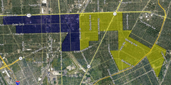 Proposed annexations from Hamtramck and Gratiot townships, April 1924.
The petitions were delivered to the Wayne County Board of Supervisors by early February 1924, and the board discussed the proposals at their February 25 meeting, according to Detroit Free Press real estate editor Logan H. Sea. In a column printed several days after the meeting, Sea reported:
Detroit's northern boundary is to be squared up to the Eight-Mile road by annexation of a district east of Dequindre street and north of the Seven-Mile road east if the voters approve this plan. At a meeting of the Wayne county board of supervisors, Monday, a petition was presented for the annexation to Detroit, of all that remains of the township of Hamtramck and also for an adjoining portion of Gratiot township, making the Eight-Mile road the northern boundary for some distance east of Gratiot avenue. The supervisors ordered these two annexation proposals submitted to a vote of the people at the presidential primary election, April 7. This does not ecect [sic] the city of Hamtramck. The proponents of these annexation proposals point out that the annexation of this district involves little additional outlay for city improvements as the existing sewer system was designed to care for most of the territory involved. The Seven-Mile road and Six-Mile road trunk sewers provide facilities for about seventy-five per cent of the township of Hamtramck and the remainder can be cared for through arms from these existing sewers. Most of the district is already provided with car serice with the Harper line on Van Dyke avenue and the D. U. R. on Gratiot avenue. There is already a considerable and rapidly growing population in the territory. This proposed annexation would bring within the city of Detroit practically the entire route of the Outer drive from Woodward avenue eastward.
("Real estate and building." Detroit Free Press, Feb. 28, 1924)
Help Wanted
 Detroit Free Press, January 17, 1924. (freep.newspapers.com)
In early 1924, notices began appearing within the Detroit Free Press want ads for canvassers to circulate annexation petitions. It is not always clear who placed the ads, such as the ones which inform applicants to see "Mr. Edwards" at the second floor of 431 Howard Street, a nine-story office building that housed multiple publishing firms. At least one ad, however, summons prospective canvassers to the Penobscot Building, suite 1102, which happened to be part of the offices of the Paterson Brothers realty firm.
 Detroit Free Press, January 19, 1924 (freep.newspapers.com)
The Paterson Brothers had recently placed on the market a 75-acre subdivision, "Outer Drive-Van Dyke," which happened to be in Hamtramck Township. In late 1923, the company's vice-president, Leonard P. Reaume, told the Detroit Free Press that so many German-born citizens were building homes in the subdivision that he expected it to become an authentic German immigrant community. ("Van Dyke will be new center." Oct. 21, 1923.) In anticipation of annexation, in June 1924 Paterson Brothers sold 24 lots from this subdivision to the Hamtramck Township School District No. 6 in order to construct a modern school building. Any debt associated with building the school would then be taken on by Detroit following annexation. ("School site is purchased." Detroit Free Press, Jun. 22, 1924.)
 Detroit Free Press, May 11, 1924. (freep.newspapers.com)
The local real estate industry, as usual, fully supported the annexations. One month before the vote, Edward A. Loveley, vice-president of the Stormfeltz-Loveley Company, told his company's force of 200 salesmen and managers, "We should take the bull by the horns at once and act on annexations." He claimed that more houses were under construction just outside the city limits than within, and that these homes ought to come into the city proper since they would benefit from city services anyway. ("Annexation is Loveley plea." Detroit Free Press, Mar. 9, 1924.) George W. Drennan, president of the real estate firm Drennan & Seldon, stressed "the importance...of making these annexation at the earliest possible moment." Drennan warned voters of "shanty towns" growing up outside the city, which would be controlled once brought into Detroit. ("Hamtramck, Gratiot annexation is urged." Detroit Free Press, Apr. 6, 1924.) Drennan's company was months away from opening "David Trombley's Harper Avenue" subdivision, a 40-acre development within the Gratiot Township annexation area.
First Attempt Fails
Although Detroit voters overwhelmingly approved the annexations on April 7, 1924, township voters rejected both. Exact numbers from the rural districts are not available, but Hamtramck Township reportedly rejected the proposal by just 15 votes. ("School site is purchased." Detroit Free Press, Jun. 22, 1924.) The real estate men got back to work, starting the petitioning process over. In the month following the election, at least three additional want ads calling for petition canvassers to apply at 431 Howard Street appeared in May 1924 editions of the Free Press, although these do not specifically mention annexation. Evidently, "Mr. Edwards" was off the job, as applicants were now instructed to see Mr. Schultz.
 Detroit Free Press, May 27, 1924. (freep.newspapers.com)
By August, the county board of supervisors had received the new petitions and approved the proposals for the September 9, 1924 election. The Hamtramck Township petition was the same, but the new Gratiot Township plan both covered more territory and was divided into three separate proposals. According to the Grosse Pointe Civic News, "the outer part of Gratiot Township was the determining factor" in the earlier rejection of the ballot measure. "The proposition this fall will be so worded that the contiguous portion of Gratiot petitioning for annexation will be admitted to the city if the voting in that section favors annexation regardless of the disposition of the rest of the township." ("Annexations again." Grosse Pointe Civic News, Aug. 1924.)

One likely reason for the increase in land to be taken from Gratiot Township was the announcement in March 1924 by the city's Rapid Transit Commission, together with the road commissions for Wayne, Oakland, and Macomb counties, of a preliminary superhighway plan for the tri-county area. Initial plans called for expanding Kelly Road (then also known as Pumpkinhook Road) as part of the system, as well as building Seven Mile Road as a superhighway, bypassing the old Morang Avenue route. With few good roads available in the area, the addition of improved highways boosted land values even when they were just lines drawn on paper.
 The bold lines on this map from the Rapid Transit Commission's final report represent roads to be made 204-foot-wide superhighways. Shaded in orange is the first, failed annexation attempt from April 1924. The additional areas included in the second proposal are in yellow.
(Hathi Trust)
As with the Cornerstone Annexation, part of the border line here follows the division between the two old French "ribbon farms" which the US government later designated as Private Claim 617 and Private Claim 123. The center line of Kelly Road follows the back borders of several old farms.

The Vote of September 9, 1924
Ahead of the election, officials from Wormer & Moore again promoted the annexation proposals. Citing company officials, one Free Press article declared that annexation would "open up a huge home building program" as well as "greatly enhance acreage values in the townships outside the annexation limits," if voters approved the measures. ("Annexation seen as aid to building." Aug. 3, 1924.) A subsequent story quoted Wormer & Moore's subdivision sales manager, William Helmer, who said, "(S)hould the city limits be extended...there is but little doubt that this district will be the center of the city's next big real estate development.... (A)ll that is needed to make (the area just outside the city) build up solidly is adequate street car or bus transportation facilities." ("Predicts growth in E. Warren area." Detroit Free Press, Aug. 24, 1924.)
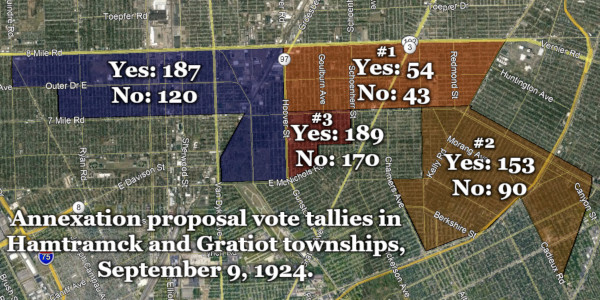
Every annexation proposal passed at the fall primary election of 1924. Hamtramck Township voted 187 to 120 in favor of joining Detroit, and city voters approved of the measure by 137,572 to 46,827. This election marked the first time that Detroit absorbed the last remnant of one of its surrounding townships. One newspaper writer described the northern strip of Hamtramck as being "too small to be divided any farther, so Detroit now has swallowed the remaining township with one gulp." ("First township annexed by city." Detroit Free Press, Sep. 13, 1924.)
The vote in Gratiot was handled differently, since only a portion of the township was being taken. Previously, when a city annexed only a portion of a township, it was necessary to separately tabulate votes from three areas: the city taking on land, the annexation area, and the unannexed portion of the township. This changed, however, when the Michigan legislature adopted Public Act 225 of 1917, enacted May 10, 1917, amending several sections of the Home Rule Cities Act. An amendment to Section 11 of the law now required that votes from the city taking on land be combined with votes from the unannexed portion of the township. The reported election totals are given below. All three proposals passed, with the narrowest margin of victory seen in the third annexation area, which won by 19 votes out of a total of 359 cast.

Encouraged by the outcome of the election, William Helmer of Wormer & Moore told the Detroit Free Press, "The assurance of city facilities in these annexed territories unquestionably will release a large volume of subdivision work and building operations.... The development will follow the course of the four main highways out of the city," referring to Gratiot, Harper, Warren, and Mack avenues. ("Annexation booms realty subdivision." Sep. 14, 1924.)
Realtors active in the newly annexed territory formed the Northeastern Development Association in November 1924, with the aim of bringing city bus service to the district, petitioning for water mains and sewers where they were not already installed, and to "obtain legislation looking toward the eventual annexation of the district beyond the Eight-mile road, in Macomb county." ("Northeast boosters seek D.S.R. bus line." Detroit Free Press, Nov. 16, 1924.) Although the idea of Detroit expanding north of Eight Mile Road was discussed in the local media during the annexation craze of the 1920s, it does not appear that any such propositions ever came to a vote.
As per the procedure at the time, the Wayne County Board of Supervisors filed a record of their annexation proceedings for both Gratiot and Hamtramck townships with the Secretary of State on December 31, 1924, making the additions to the city official on that day. The famous annexation map in the Manual of Wayne County contains a slight typo in the area representing these annexations, which mistakenly gives 1925 as the year of annexation.
 (Archive.org)
What ever happened to Gratiot Township?
 World War II memorial plaque in front of Harper Woods City Hall.
Several months following the annexation, the Houseman-Spitzley Corporation announced the opening of "East Park Manor," a subdivision straddling the Detroit-Gratiot border north of Seven Mile Road. A May 1925 advertisement breathlessly proclaims the amazing advantages of owning property near the intersection of Harper Avenue ("This artery is causing sensational value increases!") and Seven Mile Road ("Destined to be one of the greatest thoroughfares in the world!"). In July and August, the company followed up with "East Park Manor No. 1" and "East Park Manor No. 2," also split by the Detroit-Gratiot border, but up at Kelly Road.
 Detroit Free Press, May 1, 1925. (freep.newspapers.com)
These subdivisions were followed by East Park Manor numbers 3, 4 and 5 in 1926, but none of these projects saw much if any actual building activity before the October 1929 market crash. The little township—covering just 2.6 square miles of its original 18.6—would remain a quiet place for some time. The 1930 census reported a total population of just 73 people, most of whom were farmers living along Kelly Road. The "East Park Manor" subdivisions existed as merely as few unpaved roads through the fields and woods north of Seven Mile Road. Houses were built along the north side of Eastwood Avenue in the mid-1930s, but their reliance on well water and septic systems limited this type of rural development.
 Gratiot Township in 1936. ("St. Clair Shores Village Bdy" is a typo.)
(USGS Historical Topographical Map Explorer)
A second building boom finally came to the east side at the end of the 1930s, thanks to the federal government. The Housing Act of 1937 increased the ability of the Federal Housing Administration (FHA) to fund the construction of and secure mortgages on new homes built to certain quality standards. Another boost to the local housing market came when President Franklin D. Roosevelt asked congress for billions in defense spending in 1940, which stimulated manufacturing in industrial cities and increased demand for new houses for "defense workers." The East Park Manor subdivisions were perfectly situated to take advantage of both opportunities.

The Houseman-Spitzley Corporation teamed up with homebuilders General Houses Incorporated to begin filling East Park Manor with modest but well-constructed houses according to FHA guidelines. Perhaps inspired by the General Houses' success in constructing FHA homes on Detroit's far west side on Chatham Street, East Park Manor was rebranded as "Chatham Village."

This "Chatham Village" ad depicts 19171 Kingsville, on the Detroit-Gratiot border.
Detroit Free Press, Oct. 6, 1940. (freep.newspapers.com)
 Detroit Free Press, Oct. 6, 1940. (freep.newspapers.com)
By late October 1939, Houseman-Spitzley had sold 25 economically-designed houses in Chatham Village. When East Park Manor was laid out, it was taken for granted that construction would be restricted to brick—a material that was now too costly for FHA defense worker houses. Aluminum and asbestos siding were typical. Aiding the development was Gratiot Township's agreement with Detroit in January 1940 to finally receive city water service. The US Census that year shows that the township's population had increased nearly twelvefold in ten years, to 858 residents. Another 5,000 would arrive over the next four years.
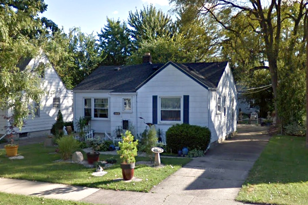 20632 Elkhart, constructed in 1941 in what was then Gratiot Township.
Possibly designed by Theodore M. Barthel, architectural supervisor for General Houses Inc.
This is one of four houses I consider to be a "childhood home" of mine.
 This 1949 aerial photo shows how quickly East Park Manor developed compared to the rest of the township north of it.
( Wayne State University)
In January 1950, the Board of Wayne County Supervisors received petitions bearing the names of more than 120 township residents asking to incorporate as the City of Harper Woods. The township's population had reached 9,148 by that year, and city-level taxing and borrowing were needed in order to improve roads and construct storm sewers. The proposal failed by a ratio of more than two-to-one, on April 17, 1950, with 1,628 voting against incorporation, and 728 voting for it. Low township taxes with city services is always a good deal when you can find it.
The following month, The J. L. Hudson Company announced plans to construct a $20,000,000 shopping center on a 102-acre tract in the northwest corner of Gratiot Township. Shopping malls were a brand new concept at the time, and this project—Eastland Center—was the first announced in Michigan, although Northland Center in Southfield was the first to be built. Gratiot Township officials approved Hudson's requested zoning change for the parcel after a public hearing in July.
 An early proposed sketch of Hudson's anchor store at Eastland Center.
Detroit Free Press, Jun 4, 1950. (freep.newspapers.com)
A second petition calling for incorporation was submitted to the county supervisors, which they approved November 27, 1950 and chose the election of February 19, 1951 to submit the question to township voters. By a margin of just 28 votes—1,104 to 1,076—the electors of Gratiot Township chose to incorporate as the City of Harper Woods. A nine-member charter commission was selected at the same election. Voters approved the new charter on October 24, 1951 by a vote of 1,482 to 981, and the first city officials were sworn in five days later.

The Final Annexation
When the East Park Manor subdivisions were laid out on top the border between Detroit and Gratiot Township, Kingsville Street was not drawn to coincide with this line, as it was in the subdivisions east of Harper Avenue. Instead, the border ran through the front lawns of every home on the south side of the street. The street was not exactly parallel to the border either. Down by Harper Avenue, the border was three feet in from the sidewalk, and up by Kelly the border is more than nine feet in. Because it was taken for granted that Detroit would continue to grow through annexation, this odd placement might have been shrugged off as a temporary inconvenience when the plat was drawn in 1925.
 Detail from plat of "East Park Manor" subdivision, by surveyors Mason L. Brown & Son, 1925.
An even more awkward situation existed at Kingsville and Kelly. The 1924 annexation proposals described the border as running down the center of Kelly from Eight Mile until reaching a point 200 feet north of and parallel to an extension of the center line of Seven Mile Road; then running east to a point 200 feet east of and parallel to the center line of Kelly; and then running south to the border between Private Claims 617 and 123.

Although odd border placements like this are not unusual, it was causing problems on Kingsville, which remained a dirt road into the late 1950s. Normally, when a street like this is paved, property owners are assessed for part of the cost. But on the south side of Kingsville, homeowners were paying tax bills ranging from $0.60 to $1.05 per year for their few feet of grass in Harper Woods—not nearly enough to justify a paving assessment. ("Harper Woods sights answer to problem." Detroit Free Press, Jan. 20, 1958.) Making matters worse, Detroit could not install fire hydrants on Kingsville because both sides of the street lay within Harper Woods.
The solution was obvious: Detroit had to annex the front lawns of its citizens along Kingsville. The action wouldn't even require a special election. Section 9 of the Home Rule Cities Act provides that:
In any case where the territory proposed to be annexed is adjacent to the city and ... consists of fractional parts of platted subdivision lots, located in an adjoining city ... the annexation may also be accomplished by the majority vote of the legislative body of the city and the approval of the legislative body of the adjoining city.... (MCL 117.9)
The city councils of Harper Woods and Detroit executed the appropriate resolutions, which were filed with the Secretary of State on March 17, 1958. To my knowledge, that was the last annexation made to Detroit, and the only one in which the city government played an active role.
The odd jog in the city border near Kelly Road was also straightened out. According to the annexation proceedings, the portions of lots 673 and 674 of "East Park Manor No. 1" on Kelly Road lying within Harper Woods were annexed to Detroit, and the portions of lots 675 and 676 lying within Detroit were annexed to Harper Woods.
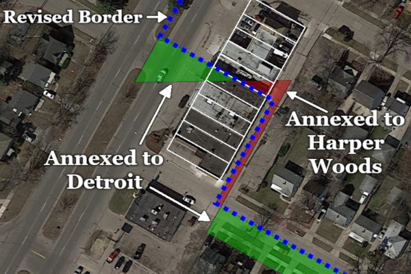

Fire hydrants were added to Kingsville following the annexation, and the street was paved. The two cities cooperated in order to better serve their citizens without resorting to contentious lawsuits. If only all border disputes could be resolved so smoothly!
Scenes Along the Border
Above is looking north/west up Kingsville Street from the intersection of Linville Street, at the southernmost tip of Harper Woods. Detroit is on the left, and Harper Woods is on the right. The surrounding subdivisions were platted so that the center of Kingsville coincides with the division line between Private Claims 617 and 123, which is the border of the city here.

Below is looking up Kingsville toward I-94. It's easy to see from this perspective how the city border used to run straight from the middle of the street here through the front lawns of the houses on the other side of the freeway, where the East Park Manor subdivisions begin.

 The border used to lie here before 1958.
 Kingsville Street, Harper Woods.
 A creatively modified home on Kingsville Street, Detroit.
 Kingsville Street, Detroit.
 Kingsville Street, Harper Woods.
 Sweetheart Bakery, Kingsville St. and Kelly Rd., Detroit.
 The border runs between Lots 674 and 675 of "East Park Manor Subdivision No. 1."
Harper Woods is on the left, Detroit is on the right.

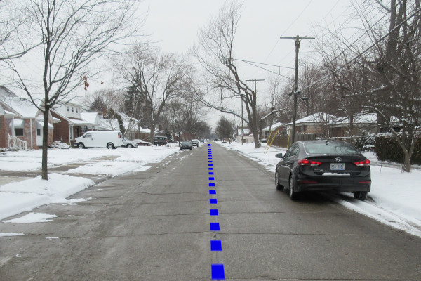
 On Kelly Road.
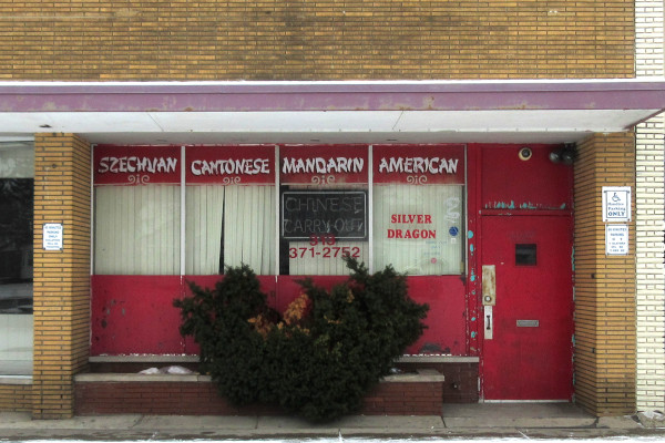 Kelly Road, Harper Woods.
 Kelly Road, Harper Woods.
 Kelly Road, Harper Woods.
 Kelly Road, Detroit.
 Chandler Park Academy High School, Harper Woods.
(Formerly known as Notre Dame High School)
(Also known as "The High School that Dave Coulier Graduated From.")
* * * * *
Click here to download the corresponding Google Earth file for this post, Borders4.KMZ.
Again, fascinating. I'd always wondered why the far south end of Harper Woods looked no different than the Detroit side of the road and was so much denser, and it's because the neighborhood was straddling the border. I assume the developers thought Detroit would eventually annex the rest of the neighborhood at the very least. I'd always heard that Harper Woods incorporated to 'protect' the tax revenue from Eastland to help fund the services of the township/aspiring city.
ReplyDeleteI'd really love to here the story about why they decided on that little notch at Kingsville and Kelly, though I guess the only people who'd know that took it to the grave. I wonder if there was something built there prior to Detroit's annexation?
Finally, at the very southeastern corner of Harper Woods at Kingsville and Linville, it appears the border travels immediately north cutting all kinds of lots before it turns into an actual street a block north at Bournemouth. Is this a mistake on online maps, or is this another example of pieces of a lot in two different cities?